Fine Art Print > Arts > Modern art pieces > Textures and patterns in modern > Modern paintings
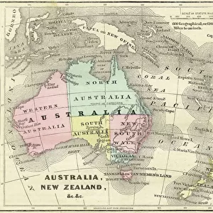
Fine Art Print : South America Physical map 1897


![]()
Fine Art Prints from Fine Art Storehouse
South America Physical map 1897
The World-Wide Atlas of Modern Geography, Political and Physical W. & A.K. Johnston - London 1897
Unleash your creativity and transform your space into a visual masterpiece!
THEPALMER
Media ID 14757130
© Roberto A Sanchez
Argentina Atlantic Ocean Atlas Backgrounds Brazil Colombia Country Geographic Area Direction Earth Latin America Pacific Ocean Paper Patina Sepia Toned South America Textured Effect Uruguay Venezuela World Map Retro Styled
A2 (42x59cm) Fine Art Print
Step back in time with our exquisite Fine Art Print of the South America Physical Map from ThePalmer, published in 1897. Part of The World-Wide Atlas of Modern Geography, Political and Physical by W. & A.K. Johnston, London, this captivating print showcases the physical features of South America as they were perceived over a century ago. Add an air of historical charm to your home or office with this intricately detailed and beautifully preserved piece of cartographical history. Each print is carefully produced using high-quality materials, ensuring a stunning and long-lasting addition to your collection.
Our Fine Art Prints are printed on 100% acid free, PH neutral paper with archival properties. This printing method is used by museums and art collections to exhibit photographs and art reproductions. Hahnemühle certified studio for digital fine art printing. Printed on 308gsm Photo Rag Paper.
Our fine art prints are high-quality prints made using a paper called Photo Rag. This 100% cotton rag fibre paper is known for its exceptional image sharpness, rich colors, and high level of detail, making it a popular choice for professional photographers and artists. Photo rag paper is our clear recommendation for a fine art paper print. If you can afford to spend more on a higher quality paper, then Photo Rag is our clear recommendation for a fine art paper print.
Estimated Image Size (if not cropped) is 42cm x 54.7cm (16.5" x 21.5")
Estimated Product Size is 42cm x 59.4cm (16.5" x 23.4")
These are individually made so all sizes are approximate
Artwork printed orientated as per the preview above, with portrait (vertical) orientation to match the source image.
FEATURES IN THESE COLLECTIONS
> Arts
> Artists
> O
> Oceanic Oceanic
> Arts
> Modern art pieces
> Textures and patterns in modern
> Modern paintings
> Arts
> Modern art pieces
> Textures and patterns in modern
> Europe
> United Kingdom
> England
> London
> Politics
> Related Images
> Europe
> United Kingdom
> England
> London
> Related Images
> Maps and Charts
> Related Images
> Maps and Charts
> World
> Fine Art Storehouse
> Map
> Historical Maps
EDITORS COMMENTS
This print takes us back in time to the year 1897, when cartography was a meticulous art form. The South America Physical map featured in this image is part of "The World-Wide Atlas of Modern Geography, Political and Physical" by W. & A. K. Johnston - London 1897. With its retro-styled appearance and antique charm, this engraved image showcases the intricate details of South America's physical geography. From Venezuela to Uruguay, Colombia to Brazil, Argentina to every country within the region, each geographic area is meticulously depicted with precision and accuracy. The sepia-toned textured effect adds an extra layer of nostalgia, as if we are peering into a treasured relic from another era. As we gaze upon this piece, we can almost feel the texture of the paper and imagine how it would have been held in hands long ago. The vastness of South America unfolds before our eyes as we observe its borders stretching across both the Pacific Ocean and Atlantic Ocean. The sea surrounding these landmasses serves as a reminder of their connection to the rest of our planet Earth. Every line etched onto this map carries with it a sense of history—a patina that speaks volumes about exploration and discovery during that time period. This print by THEPALMER transports us back in time while simultaneously reminding us of the enduring beauty found within old maps like these.
MADE IN THE UK
Safe Shipping with 30 Day Money Back Guarantee
FREE PERSONALISATION*
We are proud to offer a range of customisation features including Personalised Captions, Color Filters and Picture Zoom Tools
SECURE PAYMENTS
We happily accept a wide range of payment options so you can pay for the things you need in the way that is most convenient for you
* Options may vary by product and licensing agreement. Zoomed Pictures can be adjusted in the Basket.