Premium Framed Print > Arts > Street art graffiti > Digital art > Digital paintings
Premium Framed Print : Island of Principe Historical Map by Van Noort, Circa 1598


![]()
Framed Photos from Fine Art Storehouse
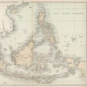
Island of Principe Historical Map by Van Noort, Circa 1598
Very Rare, Beautifully Illustrated Antique Engraved Victorian Illustration of Historical Map of Van Noort at the Island of Principe, 1598. Copyright has expired on this artwork. Digitally restored
Unleash your creativity and transform your space into a visual masterpiece!
bauhaus1000
Media ID 13667201
© bauhaus1000
103626 16th Century 16th Century Style 268399 78273 Atlantic Islands Bay Of Water Business Finance And Industry Chart Commercial Dock Design Element Diagram Direction Discovery Dutch Culture European Culture Exploration Explorer Fishing Fishing Industry Freight Transportation Image Created 16th Century Indigenous Culture Industry Island Journey Navigational Equipment Papua New Guinea People Traveling Plan Research Retail Occupation Sailing Ship Sea Passage Ship Shipping South Pacific Ocean Village Sao Tome And Principe
17"x15" (43x38cm) Premium Frame
FSC real wood frame with double mounted 10x8 print. Double mounted with white conservation mountboard. Frame moulding comprises stained composite natural wood veneers (Finger Jointed Pine) 39mm wide by 21mm thick. Archival quality Fujifilm CA photo paper mounted onto 1mm card. Overall outside dimensions are 17x15 inches (431x381mm). Rear features Framing tape to cover staples, 50mm Hanger plate, cork bumpers. Glazed with durable thick 2mm Acrylic to provide a virtually unbreakable glass-like finish. Acrylic Glass is far safer, more flexible and much lighter than typical mineral glass. Moreover, its higher translucency makes it a perfect carrier for photo prints. Acrylic allows a little more light to penetrate the surface than conventional glass and absorbs UV rays so that the image and the picture quality doesn't suffer under direct sunlight even after many years. Easily cleaned with a damp cloth. Please note that, to prevent the paper falling through the mount window and to prevent cropping of the original artwork, the visible print may be slightly smaller to allow the paper to be securely attached to the mount without any white edging showing and to match the aspect ratio of the original artwork.
FSC Real Wood Frame and Double Mounted with White Conservation Mountboard - Professionally Made and Ready to Hang
Estimated Image Size (if not cropped) is 24.4cm x 17cm (9.6" x 6.7")
Estimated Product Size is 43.1cm x 38.1cm (17" x 15")
These are individually made so all sizes are approximate
Artwork printed orientated as per the preview above, with landscape (horizontal) orientation to match the source image.
FEATURES IN THESE COLLECTIONS
> Fine Art Storehouse
> Map
> Historical Maps
> Africa
> Sao Tome and Principe
> Sao Tome
> Animals
> Mammals
> Muridae
> Water Mouse
> Arts
> Artists
> O
> Oceanic Oceanic
> Arts
> Street art graffiti
> Digital art
> Digital paintings
> Europe
> Related Images
> Maps and Charts
> Early Maps
> Maps and Charts
> Related Images
> Oceania
> Papua New Guinea
> Maps
> Oceania
> Papua New Guinea
> Related Images
EDITORS COMMENTS
This beautifully illustrated antique engraving takes us back to the 16th century, showcasing a rare historical map of the Island of Principe by Van Noort. The intricate details and craftsmanship of this print transport us to a time when cartography was both an art form and a means for exploration. The image depicts a sailing ship navigating through the vast South Pacific Ocean, symbolizing the spirit of adventure and discovery that characterized European culture during this era. As we gaze upon this woodcut illustration, we can almost feel the excitement and anticipation of those who embarked on these perilous sea passages in search of new lands. The map not only serves as a navigational tool but also offers insights into indigenous cultures, fishing practices, and village life. It provides valuable information about trade routes, commercial docks, and capital cities that were vital for maritime industry at the time. Digitally restored to its former glory, this engraving allows us to appreciate Dutch culture's influence on global exploration. With its black-and-white design elements and meticulous attention to detail, it stands as a testament to human curiosity and our relentless pursuit of knowledge. As we admire this remarkable piece from Bauhaus1000's collection at Fine Art Storehouse, let us marvel at how far we have come since Van Noort first charted these waters centuries ago.
MADE IN THE UK
Safe Shipping with 30 Day Money Back Guarantee
FREE PERSONALISATION*
We are proud to offer a range of customisation features including Personalised Captions, Color Filters and Picture Zoom Tools
SECURE PAYMENTS
We happily accept a wide range of payment options so you can pay for the things you need in the way that is most convenient for you
* Options may vary by product and licensing agreement. Zoomed Pictures can be adjusted in the Basket.