Fraud Blocker Skip to main content

Sea Passage Collection

"Journey Through the Seas

Background imageSea Passage Collection: Naval Battle on the Mississippi, 1861 Civil War Engraving

Naval Battle on the Mississippi, 1861 Civil War Engraving
Engraving of the great Naval battle on the Mississippi, passage of the Second Division of the Federal Squadron past St. Philip, April 24, 1862

Background imageSea Passage Collection: Island of Principe Historical Map by Van Noort, Circa 1598

Island of Principe Historical Map by Van Noort, Circa 1598
Very Rare, Beautifully Illustrated Antique Engraved Victorian Illustration of Historical Map of Van Noort at the Island of Principe, 1598. Copyright has expired on this artwork. Digitally restored

Background imageSea Passage Collection: Engraving of Van Noort Landing in Manila Bay, Philippines, 1600

Engraving of Van Noort Landing in Manila Bay, Philippines, 1600
Very Rare, Beautifully Illustrated Antique Engraved Victorian Illustration of Historical Engraving of Van Noort Landing in Manila Bay, Philippines, 1600. Copyright has expired on this artwork

Background imageSea Passage Collection: Historical Map of Dutch Navigators Island of Bali Illustration

Historical Map of Dutch Navigators Island of Bali Illustration
Very Rare, Beautifully Illustrated Antique Engraved Victorian Illustration of Historical Map of Dutch Navigators on the Island of Bali. Copyright has expired on this artwork. Digitally restored

Background imageSea Passage Collection: Antarctica map with sea routes of various explorers, lithograph, 1897

Antarctica map with sea routes of various explorers, lithograph, 1897
Historical map of the unexplored Antarctica with sea routes of various explorers, 18th - 19th century. Lithograph, published in 1897

Background imageSea Passage Collection: The Cocos Islands Dutch Navigation, Victorian Illustration

The Cocos Islands Dutch Navigation, Victorian Illustration
Very Rare, Beautifully Illustrated Antique Engraved Victorian Illustration of The Cocos Islands. Copyright has expired on this artwork. Digitally restored

Background imageSea Passage Collection: Dutch Navigators Encountering Flying Fish Illustration

Dutch Navigators Encountering Flying Fish Illustration
Very Rare, Beautifully Illustrated Antique Engraved Victorian Illustration of Dutch Navigators Encountering Flying Fish. Copyright has expired on this artwork. Digitally restored

Background imageSea Passage Collection: Engraving of Van Noort Sailing the Marianne Islands, 1600

Engraving of Van Noort Sailing the Marianne Islands, 1600
Very Rare, Beautifully Illustrated Antique Engraved Victorian Illustration of Historical Engraving of Van Noort Sailing the Marianne Islands, 1600. Copyright has expired on this artwork

Background imageSea Passage Collection: Jan Huygen van Linschoten Dutch Navigation, Victorian Illustration

Jan Huygen van Linschoten Dutch Navigation, Victorian Illustration
Very Rare, Beautifully Illustrated Antique Engraved Victorian Illustration of Jan Huygen van Linschoten. Copyright has expired on this artwork. Digitally restored

Background imageSea Passage Collection: Rio de Janeiro Historical Map by Van Noort, Circa 1598

Rio de Janeiro Historical Map by Van Noort, Circa 1598
Very Rare, Beautifully Illustrated Antique Engraved Victorian Illustration of Historical Map of Van Noort at Rio de Janeiro, 1598. Copyright has expired on this artwork. Digitally restored

Background imageSea Passage Collection: Van Noort at Porto Deseado Historical Map of 1598

Van Noort at Porto Deseado Historical Map of 1598
Very Rare, Beautifully Illustrated Antique Engraved Victorian Illustration of Historical Map of Van Noort at Porto Deseado, 1598. Copyright has expired on this artwork. Digitally restored

Background imageSea Passage Collection: Porto Deseado Historical Map by Van Noort, Circa 1598

Porto Deseado Historical Map by Van Noort, Circa 1598
Very Rare, Beautifully Illustrated Antique Engraved Victorian Illustration of Historical Map of Van Noort at Porto Deseado, 1598. Copyright has expired on this artwork. Digitally restored

Background imageSea Passage Collection: Strait of Magellan Map by Van Noort, Circa 1599

Strait of Magellan Map by Van Noort, Circa 1599
Very Rare, Beautifully Illustrated Antique Engraved Victorian Illustration of Historical Map of Van Noort at the Strait of Magellan, 1599. Copyright has expired on this artwork. Digitally restored

Background imageSea Passage Collection: Van Noort Sailing the Strait of Magellan, Engraving of 1600

Van Noort Sailing the Strait of Magellan, Engraving of 1600
Very Rare, Beautifully Illustrated Antique Engraved Victorian Illustration of Historical Engraving of Van Noort Sailing the Strait of Magellan, 1600. Copyright has expired on this artwork

Background imageSea Passage Collection: Van Noort Sailing the Marianne Islands, Engraving 1600

Van Noort Sailing the Marianne Islands, Engraving 1600
Very Rare, Beautifully Illustrated Antique Engraved Victorian Illustration of Historical Engraving of Van Noort Sailing the Marianne Islands, 1600. Copyright has expired on this artwork

Background imageSea Passage Collection: Theives Attacking Van Noort on the Marianne Islands, 1600

Theives Attacking Van Noort on the Marianne Islands, 1600
Very Rare, Beautifully Illustrated Antique Engraved Victorian Illustration of Historical Engraving of Van Noort Attacked by Thieives on the Marianne Islands, 1600

Background imageSea Passage Collection: Van Noort Landing in Manila Bay, Philippines Engraving, 1600

Van Noort Landing in Manila Bay, Philippines Engraving, 1600
Very Rare, Beautifully Illustrated Antique Engraved Victorian Illustration of Historical Engraving of Van Noort Landing in Manila Bay, Philippines, 1600. Copyright has expired on this artwork

Background imageSea Passage Collection: Van Noort Attacked by Theives on the Marianne Islands, 1600

Van Noort Attacked by Theives on the Marianne Islands, 1600
Very Rare, Beautifully Illustrated Antique Engraved Victorian Illustration of Historical Engraving of Van Noort Attacked by Thieives on the Marianne Islands, 1600

Background imageSea Passage Collection: Map of Van Noort at the Strait of Magellan, 1599

Map of Van Noort at the Strait of Magellan, 1599
Very Rare, Beautifully Illustrated Antique Engraved Victorian Illustration of Historical Map of Van Noort at the Strait of Magellan, 1599. Copyright has expired on this artwork. Digitally restored

Background imageSea Passage Collection: Historical Map of Van Noort at Porto Deseado, 1598

Historical Map of Van Noort at Porto Deseado, 1598
Very Rare, Beautifully Illustrated Antique Engraved Victorian Illustration of Historical Map of Van Noort at Porto Deseado, 1598. Copyright has expired on this artwork. Digitally restored

Background imageSea Passage Collection: Historical Map of Van Noort at Rio de Janeiro, 1598

Historical Map of Van Noort at Rio de Janeiro, 1598
Very Rare, Beautifully Illustrated Antique Engraved Victorian Illustration of Historical Map of Van Noort at Rio de Janeiro, 1598, from The Golden Book of the Dutch Navigators

Background imageSea Passage Collection: Historical Map of Van Noort at the Island of Principe, 1599

Historical Map of Van Noort at the Island of Principe, 1599
Very Rare, Beautifully Illustrated Antique Engraved Victorian Illustration of Historical Map of Van Noort at the Island of Principe, from The Golden Book of the Dutch Navigators

Background imageSea Passage Collection: Oliver Van Noort Dutch Navigator, Victorian Illustration, 1558-1622

Oliver Van Noort Dutch Navigator, Victorian Illustration, 1558-1622
Very Rare, Beautifully Illustrated Antique Engraved Victorian Illustration of Oliver Van Noort Dutch Navigator, Victorian Illustration, 1558-1622. Copyright has expired on this artwork

Background imageSea Passage Collection: Map of Bosphorus, Turkey, wood engraving, published in 1882

Map of Bosphorus, Turkey, wood engraving, published in 1882
Map of Bosphorus and Istanbul, Turkey. Wood engraving, published in 1882

Background imageSea Passage Collection: Historical Map of Dutch Navigators Battle in Portugal Illustration

Historical Map of Dutch Navigators Battle in Portugal Illustration
Very Rare, Beautifully Illustrated Antique Engraved Victorian Illustration of Historical Map of Dutch Navigators Battle in Portugal Illustration. Copyright has expired on this artwork

Background imageSea Passage Collection: Historical Map of Dutch Navigators Expedition to Sumatra Illustration

Historical Map of Dutch Navigators Expedition to Sumatra Illustration
Very Rare, Beautifully Illustrated Antique Engraved Victorian Illustration of Historical Map of Dutch Navigators Expedition to Sumatra. Copyright has expired on this artwork. Digitally restored

Background imageSea Passage Collection: Historical Map of Dutch Navigators Artic Expedition

Historical Map of Dutch Navigators Artic Expedition
Very Rare, Beautifully Illustrated Antique Engraved Victorian Illustration of Historical Map of Dutch Navigators Arctic Expedition. Copyright has expired on this artwork. Digitally restored

Background imageSea Passage Collection: Early Map of Dutch Navigation, Victorian Illustration

Early Map of Dutch Navigation, Victorian Illustration
Very Rare, Beautifully Illustrated Antique Engraved Victorian Illustration of Early Map of Dutch Navigation. Copyright has expired on this artwork. Digitally restored

Background imageSea Passage Collection: The Cocos Islands Dutch Navigation, Victorian Illustration

The Cocos Islands Dutch Navigation, Victorian Illustration
Very Rare, Beautifully Illustrated Antique Engraved Victorian Illustration of The Cocos Islands. Copyright has expired on this artwork. Digitally restored

Background imageSea Passage Collection: Voyages of Christopher Columbus, wood engraving, published c. 1882

Voyages of Christopher Columbus, wood engraving, published c. 1882
Map with the routes of the four voyages of Christopher Columbus in the Caribbean Sea. Wood engraving, published c. 1882

Background imageSea Passage Collection: Bosporus and Dardanelles map

Bosporus and Dardanelles map
Antique illustration of a Bosporus and Dardanelles map

Background imageSea Passage Collection: Sunset with Mountain Ranges Along Strait of Magellan, in South Americas Southern Tip

Sunset with Mountain Ranges Along Strait of Magellan, in South Americas Southern Tip
The Strait of Magellan (Estrecho de Magallanes), also called the Straits of Magellan, is a navigable sea route separating mainland South America to the north and Tierra del Fuego to the south

Background imageSea Passage Collection: Map of Arctic region indicating route followed by explorer Fridtjof Nansen on board of ship Fram

Map of Arctic region indicating route followed by explorer Fridtjof Nansen on board of ship Fram towards North Pole
Cartography. Map of the Arctic region indicating the route followed by explorer Fridtjof Nansen on board of ship Fram towards the North Pole, 1893-1896


All Professionally Made to Order for Quick Shipping

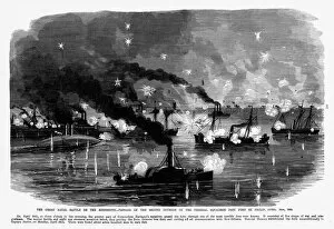
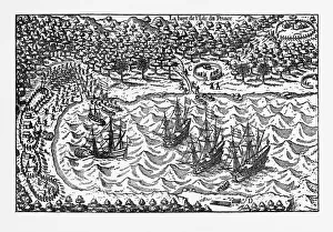
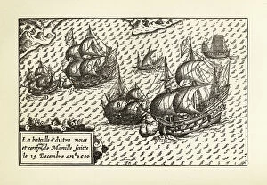
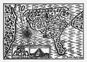
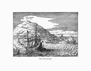
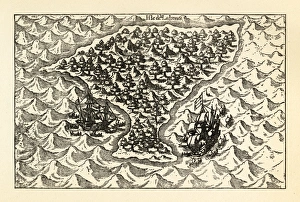
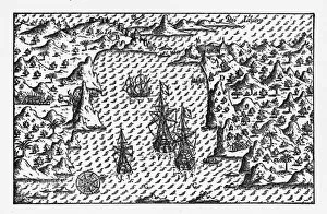
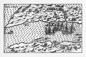
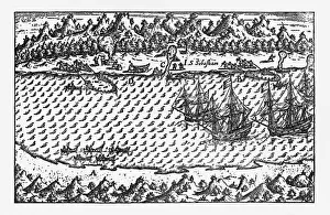
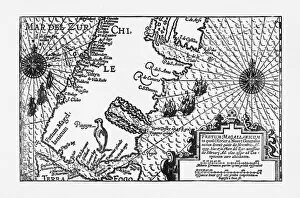
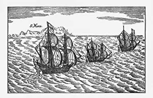
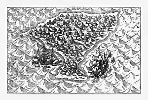
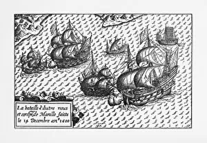
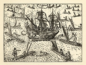
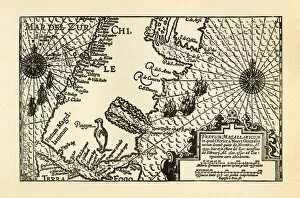
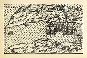
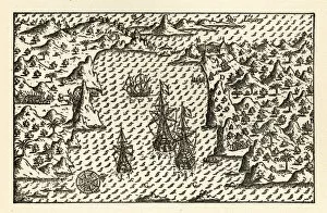
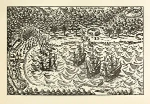
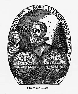
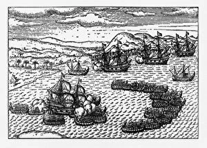
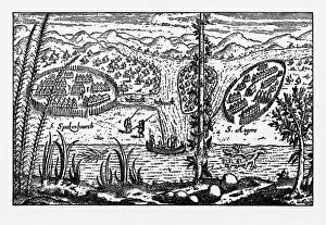
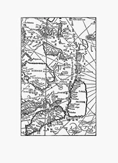
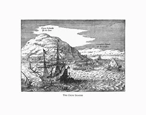
"Journey Through the Seas: Tracing Historical Sea Passages" Embark on a captivating voyage through time as we explore the fascinating sea passages that have shaped history. From naval battles to daring expeditions, these hints from various eras offer glimpses into the challenges and triumphs of seafaring adventurers. In 1861, amidst the turmoil of the Civil War, a dramatic naval battle unfolded on the mighty Mississippi River. Engraved forever in history, this clash symbolized both the power struggles and strategic importance of controlling vital waterways. Travel back even further to Circa 1598 when Dutch navigator Van Noort set sail towards uncharted territories. His historical map reveals an intriguing island called Principe, enticing us with tales of exploration and discovery. Van Noort's adventures continued as he landed in Manila Bay, Philippines in 1600. The engraving captures his arrival, reminding us of the boldness required to venture into unknown lands and encounter diverse cultures. Dutch navigators were renowned for their expertise in mapping new territories. An illustration depicting Bali Island showcases their meticulous cartography skills while shedding light on their encounters with local communities during these voyages. As we journey further across oceans, Victorian illustrations bring alive scenes from Cocos Islands where Dutch navigators marveled at nature's wonders. Flying fish soaring above sparkling waters serve as a reminder that every sea passage holds unexpected marvels waiting to be discovered. Turning our attention to Africa in 1851, a detailed map unveils Western Africa's coastline—a testament to European explorers' quest for trade routes and colonial expansion during this era. Jan Huygen van Linschoten emerges once again as his Victorian illustration portrays him navigating treacherous waters. This intrepid explorer left an indelible mark on Dutch navigation history by documenting crucial information about maritime routes across continents. The enchanting Rio de Janeiro beckons us next with its historical map from Circa 1598.