Premium Framed Print > Africa > Zambia > Maps
Premium Framed Print : Zambia. An early map of Rhodesia and Nyasaland with antiques


![]()
Framed Photos from Discover Images by AWL
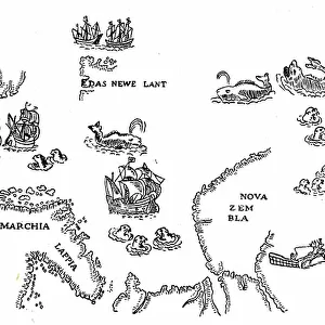
Zambia. An early map of Rhodesia and Nyasaland with antiques
Discover Images by AWL is a world-leading brand of premium quality travel images
Media ID 1646079
© John Warburton-Lee
Antique Antiques Binoculars Chiawa Camp Empire Exploration Lower Zambesi National Park Lower Zambezi National Park Nyasaland Rhodesia Victorian Zambia British Empire Looking Glass Magnifying Glass
17"x15" (43x38cm) Premium Frame
FSC real wood frame with double mounted 10x8 print. Double mounted with white conservation mountboard. Frame moulding comprises stained composite natural wood veneers (Finger Jointed Pine) 39mm wide by 21mm thick. Archival quality Fujifilm CA photo paper mounted onto 1mm card. Overall outside dimensions are 17x15 inches (431x381mm). Rear features Framing tape to cover staples, 50mm Hanger plate, cork bumpers. Glazed with durable thick 2mm Acrylic to provide a virtually unbreakable glass-like finish. Acrylic Glass is far safer, more flexible and much lighter than typical mineral glass. Moreover, its higher translucency makes it a perfect carrier for photo prints. Acrylic allows a little more light to penetrate the surface than conventional glass and absorbs UV rays so that the image and the picture quality doesn't suffer under direct sunlight even after many years. Easily cleaned with a damp cloth. Please note that, to prevent the paper falling through the mount window and to prevent cropping of the original artwork, the visible print may be slightly smaller to allow the paper to be securely attached to the mount without any white edging showing and to match the aspect ratio of the original artwork.
FSC Real Wood Frame and Double Mounted with White Conservation Mountboard - Professionally Made and Ready to Hang
Estimated Image Size (if not cropped) is 24.4cm x 20.2cm (9.6" x 8")
Estimated Product Size is 43.1cm x 38.1cm (17" x 15")
These are individually made so all sizes are approximate
Artwork printed orientated as per the preview above, with landscape (horizontal) orientation to match the source image.
FEATURES IN THESE COLLECTIONS
> Africa
> Related Images
> Africa
> Zambia
> Related Images
> Africa
> Zimbabwe
> Rhodesia
> Maps and Charts
> British Empire Maps
> Maps and Charts
> Early Maps
> Maps and Charts
> Related Images
EDITORS COMMENTS
This print takes us back in time to the historic era of Victorian exploration in Africa. The image showcases an early map of Rhodesia and Nyasaland, now known as Zambia, adorned with a collection of intriguing antiques. As we gaze upon this snapshot from history, we are transported to a bygone age filled with wonder and curiosity. The map itself is a testament to the British Empire's influence on the African continent during that period. It represents not only geographical boundaries but also the spirit of adventure and discovery that characterized this era. With its intricate details and faded colors, it invites us to delve into the past and imagine what life was like for those intrepid explorers who ventured into uncharted territories. Intriguingly, placed alongside the map are various antiques that further enhance our sense of nostalgia. A magnifying glass beckons us to examine every minute detail while binoculars hint at distant horizons waiting to be explored. These artifacts serve as tangible reminders of a time when Africa held untold mysteries and boundless possibilities. As we admire this remarkable composition captured by JWL, our imagination is ignited with thoughts of expeditions through vast wildernesses such as Lower Zambezi National Park or Chiawa Camp. This photograph encapsulates not just a moment frozen in time but also an entire chapter in African history - one defined by exploration, adventure, and the enduring allure of antique treasures from days gone by.
MADE IN THE UK
Safe Shipping with 30 Day Money Back Guarantee
FREE PERSONALISATION*
We are proud to offer a range of customisation features including Personalised Captions, Color Filters and Picture Zoom Tools
SECURE PAYMENTS
We happily accept a wide range of payment options so you can pay for the things you need in the way that is most convenient for you
* Options may vary by product and licensing agreement. Zoomed Pictures can be adjusted in the Basket.