Fraud Blocker Skip to main content

Empire Collection

"Tracing the Footsteps of Empires

Background imageEmpire Collection: Antique map of the Roman Empire

Antique map of the Roman Empire, with a detail on Rome

Background imageEmpire Collection: The Man Sing Palace, Gwalior, c1880 (1905). Artist: Alexander Henry Hallam Murray

The Man Sing Palace, Gwalior, c1880 (1905). Artist: Alexander Henry Hallam Murray
The Man Sing Palace, Gwalior, c1880 (1905). From The High-Road of Empire, by A. H. Hallam Murray. [John Murray, Ablemarle Street, London, 1905]

Background imageEmpire Collection: Map of the Byzantine Empire in the 9th Century

Map of the Byzantine Empire in the 9th Century
Vintage engraving of a Map of the Byzantine Empire in the 9th Century

Background imageEmpire Collection: Orteliuss map of Ottoman Empire, 1570

Orteliuss map of Ottoman Empire, 1570
Orteliuss map of the Ottoman Empire. This map is from the 1570 first edition of Theatrum orbis terrarum ( Theatre of the World )

Background imageEmpire Collection: French uniforms during the Napoleonic Wars

French uniforms during the Napoleonic Wars
French army uniforms: infantry 1814-1825, grenadier 1812-1815, and cavalry 1805-1812. Antique hand-colored print

Background imageEmpire Collection: Greece at the beginning of the Peloponnesian War (431-404 BC)

Greece at the beginning of the Peloponnesian War (431-404 BC)
Antique Map of Greece at the beginning of the Peloponnesian War (431 - 404 BC) with the different tribal groups. Steel engraving with hand colored borderlines, published in 1861

Background imageEmpire Collection: British Empire world map, 19th century

British Empire world map, 19th century
British Empire world map. This world map shows the 19th-century British Empire (pink) and its indigenous peoples. Five illustrations (clockwise from upper left) show the people of Australia

Background imageEmpire Collection: Map of the Roman Empire

Map of the Roman Empire
Map showing the extent of the Roman Empire. Hand-colored woodcut of a 19th-century illustration

Background imageEmpire Collection: Dance in the public ballroom of the Imperial Palace, Vienna. Watercolor by Wilhelm Gause, 1900

Dance in the public ballroom of the Imperial Palace, Vienna. Watercolor by Wilhelm Gause, 1900
COURT BALL AT THE HOFBURG. Dance in the public ballroom of the Imperial Palace, Vienna. Watercolor by Wilhelm Gause, 1900. Emperor Francis Joseph is on the far right

Background imageEmpire Collection: MAP OF MACEDONIAN EMPIRE. Map of the Macedonian Empire following the conquests of Alexander

MAP OF MACEDONIAN EMPIRE. Map of the Macedonian Empire following the conquests of Alexander the Great, 4th century B.C

Background imageEmpire Collection: French soldiers uniforms, 1790s

French soldiers uniforms, 1790s
French hussar, cavalry, and infantry uniforms, 1795-1796. Antique hand-colored print

Background imageEmpire Collection: Antique damaged map of German Empire 19th Century

Antique damaged map of German Empire 19th Century

Background imageEmpire Collection: Flags of the German Empire

Flags of the German Empire
Illustration of a Flags of the German Empire

Background imageEmpire Collection: Napoleon, (1769-1821), c1894-95, (1936). Creator: James Sant

Napoleon, (1769-1821), c1894-95, (1936). Creator: James Sant
Napoleon, (1769-1821), c1894-95, (1936). Last portrait of Napoleon Bonaparte (1769-1821) commissioned to James Sant (1820-1916)

Background imageEmpire Collection: Antique map of India

Antique map of India, 1864

Background imageEmpire Collection: Ancient History - Map of Alexander the Great Campaigns

Ancient History - Map of Alexander the Great Campaigns
Vintage engraving of a map of the campaigns and marches of Alexander the Great

Background imageEmpire Collection: Caesar crossing the Rubicon

Caesar crossing the Rubicon
Illustration of a Caesar crossing the Rubicon. This event of crossing a small stream in Northern Italy became one of ancient historys most pivotal events, for from it sprang the Roman Empire

Background imageEmpire Collection: Map of the world, 1720

Map of the world, 1720
(Original Caption) 18th century map of the world. Published in Paris in 1720, this French map shows the known world, including the new lands that had been discovered in the preceding centuries by

Background imageEmpire Collection: Portrait of Robert Clive (1725-1774) 1st Baron Clive, 1773 (oil on canvas)

Portrait of Robert Clive (1725-1774) 1st Baron Clive, 1773 (oil on canvas)
XCF268080 Portrait of Robert Clive (1725-1774) 1st Baron Clive, 1773 (oil on canvas) by Dance-Holland, Nathaniel (1735-1811) (studio of); 127.6x102.2 cm; National Portrait Gallery, London

Background imageEmpire Collection: ROME: YOUNG WOMAN. Young woman gathering flowers: Roman wall fresco, 1st century A. D

ROME: YOUNG WOMAN. Young woman gathering flowers: Roman wall fresco, 1st century A. D
ROME: YOUNG WOMAN. Young woman gathering flowers: Roman wall fresco, 1st century A.D

Background imageEmpire Collection: COUTURE: A ROMAN FEAST. Oil on canvas, 1843, by Thomas Couture

COUTURE: A ROMAN FEAST. Oil on canvas, 1843, by Thomas Couture

Background imageEmpire Collection: Wembley Stadium Art - England

Wembley Stadium Art - England
Watercolour of Wembley Stadium, former home of the Football Association(FA) and England national football team, 1923 - 2000

Background imageEmpire Collection: The Garden of Earthly Delights, 1500s

The Garden of Earthly Delights, 1500s. Bosch, Hieronymus (1450?1516). Found in the collection of the Museo del Prado, Madrid

Background imageEmpire Collection: Illustrated map of India showing ancient Mauryan empire

Illustrated map of India showing ancient Mauryan empire

Background imageEmpire Collection: Colosseum reflected at sunrise, Rome, Italy

Colosseum reflected at sunrise, Rome, Italy
The Colosseum (Flavian Amphitheatre) at sunrise, still illuminated by artificial light. Rome, Italy

Background imageEmpire Collection: The Plum Pudding in Danger, 1805 (coloured engraving) (see also 152999)

The Plum Pudding in Danger, 1805 (coloured engraving) (see also 152999)
XIR158226 The Plum Pudding in Danger, 1805 (coloured engraving) (see also 152999) by Gillray, James (1757-1815); Musee de la Ville de Paris, Musee Carnavalet, Paris

Background imageEmpire Collection: ROMAN GLADIATORS. Roman mosaic of a gladiatorial combat

ROMAN GLADIATORS. Roman mosaic of a gladiatorial combat

Background imageEmpire Collection: ROMAN EMPIRE: MAP OF ROME. Plan of Rome at the time of Augustus, first Roman emperor, 27 B. C

ROMAN EMPIRE: MAP OF ROME. Plan of Rome at the time of Augustus, first Roman emperor, 27 B. C. -14 A. D
ROMAN EMPIRE: MAP OF ROME. Plan of Rome at the time of Augustus, first Roman emperor, 27 B.C.-14 A.D

Background imageEmpire Collection: PROY2A-00017

PROY2A-00017
Map of Europe in the time of Charlemagne, 768-814 AD. Printed color lithograph, 19th century

Background imageEmpire Collection: Arab empire, mid-700s

Arab empire, mid-700s
Empire of the Arab Caliphs, middle of the 8th century. Printed color lithograph

Background imageEmpire Collection: The New Sheffield Empire Palace, Charles Street, programme, 1906

The New Sheffield Empire Palace, Charles Street, programme, 1906
Original at Sheffield Local Studies Library (MP 6600 M)

Background imageEmpire Collection: Germany and the northern provinces of the roman empire map 1895

Germany and the northern provinces of the roman empire map 1895
Encyclopedia Britannica 9th Edition Vol I New York, Samuel Hall 1878

Background imageEmpire Collection: Antique Greece empire map 1895

Antique Greece empire map 1895
Encyclopedia Britannica 9th Edition Vol I New York, Samuel Hall 1878

Background imageEmpire Collection: Map of Europe after the Peace of Tilsit in 1807, from A Short History of the

Map of Europe after the Peace of Tilsit in 1807, from A Short History of the
KW392529 Map of Europe after the Peace of Tilsit in 1807, from A Short History of the English People by J. R. Green, published 1893 (colour litho) by English School

Background imageEmpire Collection: Historic, Sculpture

Historic, Sculpture
Antinous (110-130). Member of the Roman Emperor Hadrians entourage, to whom he was beloved. Bust. Marble. Dated 130-138. Found in Patras. National Archaeological Museum. Athens, Greece

Background imageEmpire Collection: MAP OF THE ROMAN EMPIRE. From the 1595 atlas, Theatrum Orbis Terrarum

MAP OF THE ROMAN EMPIRE. From the 1595 atlas, Theatrum Orbis Terrarum, by Abraham Oertel, also known as Ortelius, featuring portraits of Roma, deity of ancient Rome, and Romulus

Background imageEmpire Collection: Extent of the Persian empire

Extent of the Persian empire
Map of the ancient Persian empire. Printed color lithograph of a 19th-century illustration

Background imageEmpire Collection: Map of Europe, 1700

Map of Europe, 1700
17th century map of Europe. Published in 1700, this map by the Dutch cartographer Frederick de Witt (1630-1706) shows the latest knowledge of the geography of Europe

Background imageEmpire Collection: Madame Recamier, 1800 (oil on canvas)

Madame Recamier, 1800 (oil on canvas)
XIR8996 Madame Recamier, 1800 (oil on canvas) by David, Jacques Louis (1748-1825); 174x244 cm; Louvre, Paris, France; French, out of copyright

Background imageEmpire Collection: Frederick I Barbarossa Holy Roman Emperor

Frederick I Barbarossa Holy Roman Emperor
Frederick I Barbarossa (1122-1190), King of Germany and Holy Roman Emperor. Born in Swabia in southern Germany, Frederick succeeded his father as Duke in 1147

Background imageEmpire Collection: French military uniforms, 1795

French military uniforms, 1795
French general (left) and infantry officers, 1795. Antique hand-colored print

Background imageEmpire Collection: EARLY CHRISTIAN: CHRIST. Head of Christ, from the catacomb of St. Priscilla, Rome, Italy

EARLY CHRISTIAN: CHRIST. Head of Christ, from the catacomb of St. Priscilla, Rome, Italy. 2nd or 3rd century A. D
EARLY CHRISTIAN: CHRIST. Head of Christ, from the catacomb of St. Priscilla, Rome, Italy. 2nd or 3rd century A.D

Background imageEmpire Collection: EGYPTIAN TOMB PAINTING. Tomb of Anhurkhawi

EGYPTIAN TOMB PAINTING. Tomb of Anhurkhawi. Fresco of dead man standing before phoenix of Heliopolis. Ramessid period

Background imageEmpire Collection: Scene from Song of Roland

Scene from Song of Roland
Roland blowing his warhorn in battle against the Saracens at Roncesvalle, 789 AD. Hand-colored woodcut of a 19th-century illustration

Background imageEmpire Collection: Map of the Muslim expansion and the Byzantine Empire at the end of the Umayyad Caliphate, in 750

Map of the Muslim expansion and the Byzantine Empire at the end of the Umayyad Caliphate, in 750. From Historical Atlas, published 1923

Background imageEmpire Collection: Meeting between Pope Adrian I and Charlemagne, miniature in the incunabula Chronicles

Meeting between Pope Adrian I and Charlemagne, miniature in the incunabula Chronicles of France, printed by A. Verard, Paris, 1493

Background imageEmpire Collection: Illustrated map of Indus Valley civilisation

Illustrated map of Indus Valley civilisation

Background imageEmpire Collection: BAHADUR SHAH II (1775-1862). Last Mughal emperor of India (1837-58). Mughal painting

BAHADUR SHAH II (1775-1862). Last Mughal emperor of India (1837-58). Mughal painting, 19th century


All Professionally Made to Order for Quick Shipping

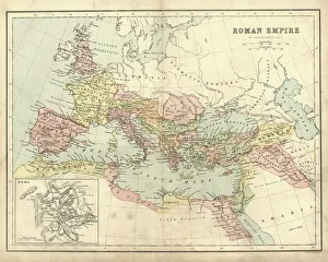
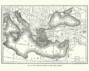
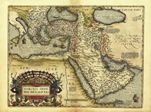
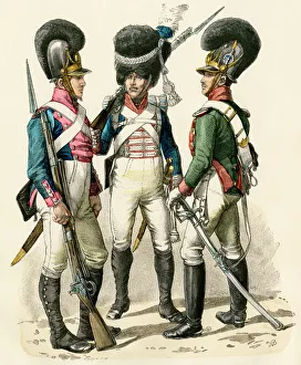
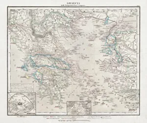
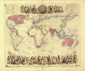
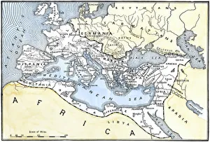
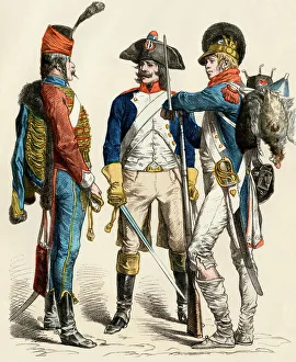
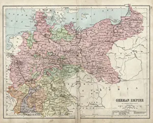
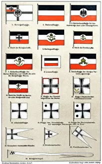
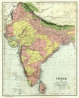
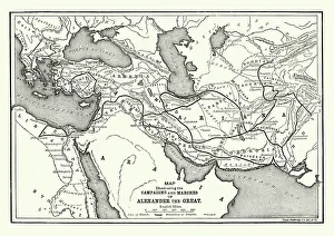
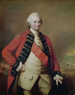
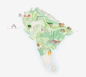
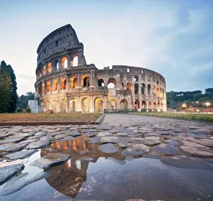
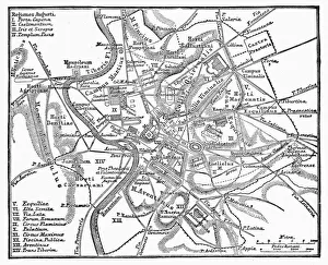
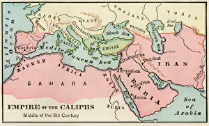
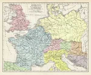
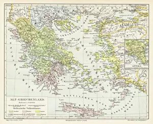
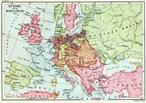
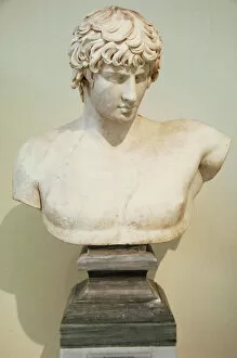
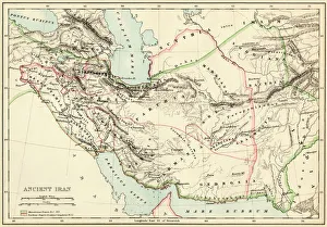
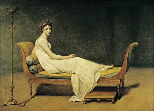
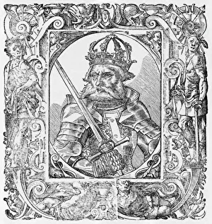
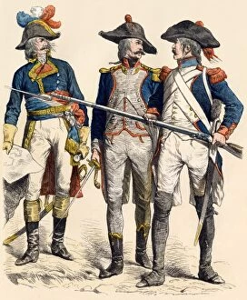
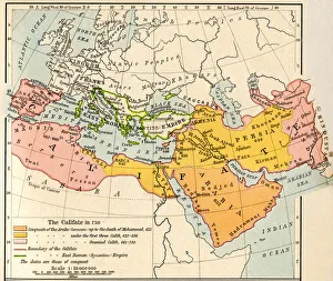
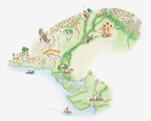
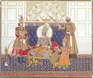
"Tracing the Footsteps of Empires: A Journey through Time and Territories" Step into the captivating world of empires with a collection of antique maps that unveil their grandeur and influence. Delve into the depths of history as you explore an ancient map showcasing the sprawling Roman Empire, a testament to its dominance in antiquity. Marvel at the Byzantine Empire's vast territories depicted on a 9th-century map, revealing its enduring legacy. Transport yourself to an era when Britannia ruled the waves with a meticulously detailed 19th-century world map illustrating the expanse of the British Empire. Witness Ottoman magnificence unfold before your eyes through Orteliuss' intricate cartography from 1570, capturing every inch of this formidable empire. Travel back even further to Greece during one of its most tumultuous periods -the Peloponnesian War- as portrayed on an intriguing historical map. Immerse yourself in Roman glory once again with another depiction highlighting their extensive dominion across Europe, Africa, and Asia. Discover remnants of German history etched upon a damaged yet evocative 19th-century map showcasing the German Empire's territorial reach. Follow in Alexander the Great's footsteps by exploring his Macedonian Empire after his legendary conquests reshaped nations forever. Venture beyond geographical boundaries and delve into artistic expressions depicting societal dynamics during different epochs. Behold Hieronymus Bosch's enigmatic "The Garden of Earthly Delights, " inviting contemplation on human desires and earthly pursuits during Renaissance times. Witness political satire come alive through "The Plum Pudding in Danger, " offering insight into European power struggles amidst Napoleon Bonaparte's reign. Admire French uniforms adorning soldiers who fought valiantly during Napoleonic Wars, symbolizing both military might and national identity. Finally, gaze upon flags representing unity under Germany's imperial banner while reflecting upon shifting alliances throughout time.