Framed Print > Africa > Zambia > Maps
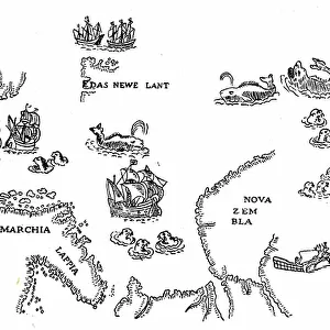
Framed Print : Zambia. An early map of Rhodesia and Nyasaland with antiques


![]()
Framed Photos from Discover Images by AWL
Zambia. An early map of Rhodesia and Nyasaland with antiques
Discover Images by AWL is a world-leading brand of premium quality travel images
Media ID 1646079
© John Warburton-Lee
Antique Antiques Binoculars Chiawa Camp Empire Exploration Lower Zambesi National Park Lower Zambezi National Park Nyasaland Rhodesia Victorian Zambia British Empire Looking Glass Magnifying Glass
14"x12" (38x32cm) Modern Frame
Step back in time with our exquisite Framed Print of "Zambia. An early map of Rhodesia and Nyasaland with antiques" by JWL from Discover Images by AWL. This vintage map, showcasing the historical territories of Rhodesia and Nyasaland, is beautifully framed with an elegant antique finish. Add an air of sophistication and intrigue to any room with this captivating piece of historical art. Each print is meticulously crafted to preserve the rich details and authenticity of the original image. Bring a piece of history into your home and start a conversation with this unique Framed Print from Media Storehouse.
Wood effect frame, card mounted, 10x8 archival quality photo print. Overall outside dimensions 14x12 inches (38x32cm). Environmentally and ozone friendly, 40mm wide x 15mm Polycore® moulding has the look of real wood, is durable and light and easy to hang. Biodegradable and made with non-chlorinated gases (no toxic fumes) it is efficient; producing 100 tons of polystyrene can save 300 tons of trees! Prints are glazed with lightweight, shatterproof, optical clarity acrylic (providing the same general protection from the environment as glass). The back is stapled hardboard with a sawtooth hanger attached. Note: To minimise original artwork cropping, for optimum layout, and to ensure print is secure, the visible print may be marginally smaller
Contemporary Framed and Mounted Prints - Professionally Made and Ready to Hang
Estimated Image Size (if not cropped) is 24.4cm x 20.2cm (9.6" x 8")
Estimated Product Size is 37.6cm x 32.5cm (14.8" x 12.8")
These are individually made so all sizes are approximate
Artwork printed orientated as per the preview above, with landscape (horizontal) orientation to match the source image.
FEATURES IN THESE COLLECTIONS
> Africa
> Related Images
> Africa
> Zambia
> Related Images
> Africa
> Zimbabwe
> Rhodesia
> Maps and Charts
> British Empire Maps
> Maps and Charts
> Early Maps
> Maps and Charts
> Related Images
EDITORS COMMENTS
This print takes us back in time to the historic era of Victorian exploration in Africa. The image showcases an early map of Rhodesia and Nyasaland, now known as Zambia, adorned with a collection of intriguing antiques. As we gaze upon this snapshot from history, we are transported to a bygone age filled with wonder and curiosity. The map itself is a testament to the British Empire's influence on the African continent during that period. It represents not only geographical boundaries but also the spirit of adventure and discovery that characterized this era. With its intricate details and faded colors, it invites us to delve into the past and imagine what life was like for those intrepid explorers who ventured into uncharted territories. Intriguingly, placed alongside the map are various antiques that further enhance our sense of nostalgia. A magnifying glass beckons us to examine every minute detail while binoculars hint at distant horizons waiting to be explored. These artifacts serve as tangible reminders of a time when Africa held untold mysteries and boundless possibilities. As we admire this remarkable composition captured by JWL, our imagination is ignited with thoughts of expeditions through vast wildernesses such as Lower Zambezi National Park or Chiawa Camp. This photograph encapsulates not just a moment frozen in time but also an entire chapter in African history - one defined by exploration, adventure, and the enduring allure of antique treasures from days gone by.
MADE IN THE UK
Safe Shipping with 30 Day Money Back Guarantee
FREE PERSONALISATION*
We are proud to offer a range of customisation features including Personalised Captions, Color Filters and Picture Zoom Tools
SECURE PAYMENTS
We happily accept a wide range of payment options so you can pay for the things you need in the way that is most convenient for you
* Options may vary by product and licensing agreement. Zoomed Pictures can be adjusted in the Basket.