Poster Print > Universal Images Group (UIG) > Universal Images Group > Satellite and Aerial > Planet Observer 4
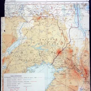
Poster Print : Uganda, Relief Map with Border and Mask


![]()
Poster Prints from Universal Images Group (UIG)
Uganda, Relief Map with Border and Mask
Relief map of Uganda (with border and mask). This image was compiled from data acquired by landsat 5 & 7 satellites combined with elevation data
Universal Images Group (UIG) manages distribution for many leading specialist agencies worldwide
Media ID 9619123
© Planet Observer/UIG
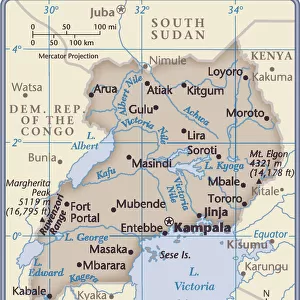
Africa Great Lakes Lake Victoria Relief Map Uganda Kampala Satellite View
A2 (59.4 x 42cm) Poster Print
Discover the beauty and complexity of Uganda with our stunning Relief Map Poster Print from Media Storehouse, in partnership with Universal Images Group (UIG). Meticulously created using satellite data from Landsat 5 & 7, this captivating poster reveals the intricate terrain of Uganda, complete with its distinct borders and a traditional Ugandan mask symbol. Bring the wonders of geography into your home or office and ignite curiosity with this unique and visually engaging representation of Uganda's landscape.
A2 Poster (59.4 x 42cm, 23.4" x 16.5" inches) printed on 170gsm Satin Poster Paper. Securely packaged, rolled and inserted into a strong mailing tube and shipped tracked. Poster Prints are of comparable archival quality to our Photographic prints, they are simply printed on thinner Poster Paper. Whilst we only use Photographic Prints in our frames, you can frame Poster Prints if they are carefully supported to prevent sagging over time.
Poster prints are budget friendly enlarged prints in standard poster paper sizes (A0, A1, A2, A3 etc). Whilst poster paper is sometimes thinner and less durable than our other paper types, they are still ok for framing and should last many years. Our Archival Quality Photo Prints and Fine Art Paper Prints are printed on higher quality paper and the choice of which largely depends on your budget.
Estimated Product Size is 42cm x 59.4cm (16.5" x 23.4")
These are individually made so all sizes are approximate
Artwork printed orientated as per the preview above, with portrait (vertical) orientation to match the source image.
EDITORS COMMENTS
This stunning print showcases the intricate beauty of Uganda's relief map, adorned with a border and mask. Compiled from data acquired by Landsat 5 & 7 satellites, combined with elevation data, this image offers a unique perspective on the physical geography of Uganda. The horizontal composition allows for an immersive viewing experience, transporting you to the heart of Africa. The vibrant colors bring out the diverse topography of this East African nation. From the majestic Great Lakes region to the bustling cityscape of Kampala, every detail is captured in this photograph. Lake Victoria takes center stage as it glistens under the golden sunlight, reflecting its significance as one of Africa's largest freshwater bodies. With no people in sight, this image invites you to explore Uganda's natural wonders at your own pace. The relief map provides valuable insights into the country's terrain and geographical features while highlighting its rich cultural heritage. Whether you are a cartography enthusiast or simply appreciate breathtaking landscapes, this print is sure to captivate your imagination. It serves as a reminder that our world is filled with hidden treasures waiting to be discovered and appreciated
MADE IN THE UK
Safe Shipping with 30 Day Money Back Guarantee
FREE PERSONALISATION*
We are proud to offer a range of customisation features including Personalised Captions, Color Filters and Picture Zoom Tools
SECURE PAYMENTS
We happily accept a wide range of payment options so you can pay for the things you need in the way that is most convenient for you
* Options may vary by product and licensing agreement. Zoomed Pictures can be adjusted in the Basket.