Canvas Print > Universal Images Group (UIG) > Universal Images Group > Satellite and Aerial > Planet Observer 4
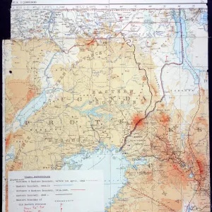
Canvas Print : Uganda, Relief Map with Border and Mask


![]()
Canvas Prints from Universal Images Group (UIG)
Uganda, Relief Map with Border and Mask
Relief map of Uganda (with border and mask). This image was compiled from data acquired by landsat 5 & 7 satellites combined with elevation data
Universal Images Group (UIG) manages distribution for many leading specialist agencies worldwide
Media ID 9619123
© Planet Observer/UIG
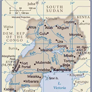
Africa Great Lakes Lake Victoria Relief Map Uganda Kampala Satellite View
20"x16" (50x40cm) Canvas Print
Discover the beauty and complexity of Uganda with our Canvas Print from Media Storehouse, featuring a unique and captivating relief map from Universal Images Group (UIG). This stunning image showcases the intricate geography of Uganda, complete with borders and a traditional African mask symbol. Compiled using data from Landsat 5 & 7 satellites and elevation data, this relief map offers a visually engaging representation of the diverse terrain of this fascinating country. Bring the wonders of Uganda into your home or office with our high-quality Canvas Print, perfect for adding a touch of world culture and intrigue to any space.
Ready to hang Premium Gloss Canvas Print. Our archival quality canvas prints are made from Polyester and Cotton mix and stretched over a 1.25" (32mm) kiln dried knot free wood stretcher bar. Packaged in a plastic bag and secured to a cardboard insert for transit.
Canvas Prints add colour, depth and texture to any space. Professionally Stretched Canvas over a hidden Wooden Box Frame and Ready to Hang
Estimated Product Size is 40.6cm x 50.8cm (16" x 20")
These are individually made so all sizes are approximate
Artwork printed orientated as per the preview above, with portrait (vertical) orientation to match the source image.
EDITORS COMMENTS
This stunning print showcases the intricate beauty of Uganda's relief map, adorned with a border and mask. Compiled from data acquired by Landsat 5 & 7 satellites, combined with elevation data, this image offers a unique perspective on the physical geography of Uganda. The horizontal composition allows for an immersive viewing experience, transporting you to the heart of Africa. The vibrant colors bring out the diverse topography of this East African nation. From the majestic Great Lakes region to the bustling cityscape of Kampala, every detail is captured in this photograph. Lake Victoria takes center stage as it glistens under the golden sunlight, reflecting its significance as one of Africa's largest freshwater bodies. With no people in sight, this image invites you to explore Uganda's natural wonders at your own pace. The relief map provides valuable insights into the country's terrain and geographical features while highlighting its rich cultural heritage. Whether you are a cartography enthusiast or simply appreciate breathtaking landscapes, this print is sure to captivate your imagination. It serves as a reminder that our world is filled with hidden treasures waiting to be discovered and appreciated
MADE IN THE UK
Safe Shipping with 30 Day Money Back Guarantee
FREE PERSONALISATION*
We are proud to offer a range of customisation features including Personalised Captions, Color Filters and Picture Zoom Tools
SECURE PAYMENTS
We happily accept a wide range of payment options so you can pay for the things you need in the way that is most convenient for you
* Options may vary by product and licensing agreement. Zoomed Pictures can be adjusted in the Basket.