Poster Print > Europe > United Kingdom > Scotland > Edinburgh > Edinburgh
Poster Print : Map of Ladysmith and Surrounding Heights, 1900. Creator: Unknown


![]()
Poster Prints from Heritage Images
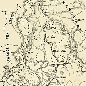
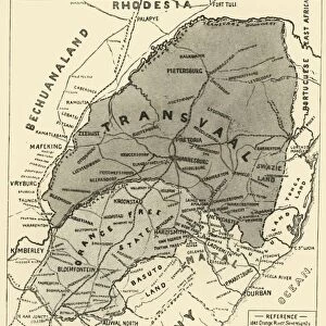
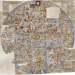
Map of Ladysmith and Surrounding Heights, 1900. Creator: Unknown
Map of Ladysmith and Surrounding Heights, 1900. From " South Africa and the Transvaal War, Vol. II", by Louis Creswicke. [T. C. & E. C. Jack, Edinburgh, 1900]
Heritage Images features heritage image collections
Media ID 19780723
© The Print Collector/Heritage Images
Cartography Creswicke Jack Ladysmith Louis Louis Creswicke Map Making Mapmaking Natal Province Of Kwazulu Natal South Africa South Africa And The Transvaal War Tc And Ec Tc And Ec Jack
A2 (59.4 x 42cm) Poster Print
Step back in time with our vintage Map of Ladysmith and Surrounding Heights print from Media Storehouse. This historical image, taken from "South Africa and the Transvaal War, Vol. II" by Louis Creswicke, published in 1900, showcases the layout of Ladysmith and its surrounding heights during a pivotal moment in South African history. The intricate details of the map, including fortifications and topography, offer a glimpse into the past, making this print an excellent addition to any history or decor enthusiast's collection. With its rich heritage and unknown creator from Heritage Images, this map print is a captivating conversation starter and a beautiful reminder of the past.
A2 Poster (59.4 x 42cm, 23.4" x 16.5" inches) printed on 170gsm Satin Poster Paper. Securely packaged, rolled and inserted into a strong mailing tube and shipped tracked. Poster Prints are of comparable archival quality to our Photographic prints, they are simply printed on thinner Poster Paper. Whilst we only use Photographic Prints in our frames, you can frame Poster Prints if they are carefully supported to prevent sagging over time.
Poster prints are budget friendly enlarged prints in standard poster paper sizes (A0, A1, A2, A3 etc). Whilst poster paper is sometimes thinner and less durable than our other paper types, they are still ok for framing and should last many years. Our Archival Quality Photo Prints and Fine Art Paper Prints are printed on higher quality paper and the choice of which largely depends on your budget.
Estimated Image Size (if not cropped) is 42cm x 52.6cm (16.5" x 20.7")
Estimated Product Size is 42cm x 59.4cm (16.5" x 23.4")
These are individually made so all sizes are approximate
Artwork printed orientated as per the preview above, with portrait (vertical) orientation to match the source image.
FEATURES IN THESE COLLECTIONS
> Africa
> Related Images
> Africa
> South Africa
> Maps
> Africa
> South Africa
> Related Images
> Arts
> Literature
> Illustration
> Arts
> Literature
> Europe
> United Kingdom
> Scotland
> Edinburgh
> Edinburgh
> Europe
> United Kingdom
> Scotland
> Lothian
> Edinburgh
> Maps and Charts
> Related Images
EDITORS COMMENTS
This print showcases a historical treasure, the "Map of Ladysmith and Surrounding Heights, 1900". The creator remains unknown, adding an air of mystery to this remarkable piece. Extracted from Louis Creswicke's renowned book "South Africa and the Transvaal War, Vol. II" published in Edinburgh by T. C. & E. C. Jack in 1900, this map offers a glimpse into the past. The map itself is a testament to the artistry and skill of cartography during that era. It provides an intricate depiction of Ladysmith and its surrounding areas within South Africa's KwaZulu-Natal province. Its detailed illustrations capture not only geographical features but also offer insights into the country's rich history. As we delve into this visual masterpiece, we are transported back to the turn of the twentieth century—a time when South Africa was undergoing significant changes. This print serves as a window into African literature and geography at that time. Preserved by The Print Collector, it stands as a valuable artifact showcasing both cultural heritage and historical significance. With its delicate lines and meticulous attention to detail, this map invites us to explore Ladysmith's landscape through the eyes of those who came before us. Whether you are fascinated by maps or have an interest in South African history, this extraordinary print will surely captivate your imagination with its blend of artistry and information about Ladysmith in 1900s colonial Africa.
MADE IN THE UK
Safe Shipping with 30 Day Money Back Guarantee
FREE PERSONALISATION*
We are proud to offer a range of customisation features including Personalised Captions, Color Filters and Picture Zoom Tools
SECURE PAYMENTS
We happily accept a wide range of payment options so you can pay for the things you need in the way that is most convenient for you
* Options may vary by product and licensing agreement. Zoomed Pictures can be adjusted in the Basket.