Fine Art Print > Europe > United Kingdom > Scotland > Edinburgh > Edinburgh
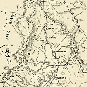
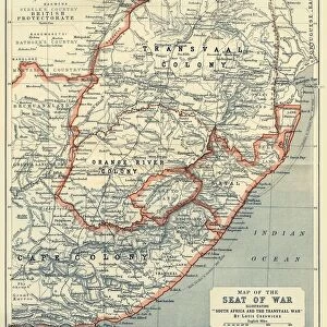
Fine Art Print : Map of Ladysmith and Surrounding Heights, 1900. Creator: Unknown


![]()
Fine Art Prints from Heritage Images
Map of Ladysmith and Surrounding Heights, 1900. Creator: Unknown
Map of Ladysmith and Surrounding Heights, 1900. From " South Africa and the Transvaal War, Vol. II", by Louis Creswicke. [T. C. & E. C. Jack, Edinburgh, 1900]
Heritage Images features heritage image collections
Media ID 19780723
© The Print Collector/Heritage Images
Cartography Creswicke Jack Ladysmith Louis Louis Creswicke Map Making Mapmaking Natal Province Of Kwazulu Natal South Africa South Africa And The Transvaal War Tc And Ec Tc And Ec Jack
A2 (42x59cm) Fine Art Print
Step back in time with our exquisite Fine Art Print of the Map of Ladysmith and Surrounding Heights from 1900. This captivating vintage map, sourced from the pages of "South Africa and the Transvaal War, Vol. II," offers a unique glimpse into the historical landscape of Ladysmith during a pivotal period. Created by an unknown artist and published by T. C. & E. C. Jack in Edinburgh, this intricately detailed map showcases the strategic heights and fortifications that played a significant role in the South African War. Add this stunning piece to your collection and bring a piece of history into your home or office.
Our Fine Art Prints are printed on 100% acid free, PH neutral paper with archival properties. This printing method is used by museums and art collections to exhibit photographs and art reproductions. Hahnemühle certified studio for digital fine art printing. Printed on 308gsm Photo Rag Paper.
Our fine art prints are high-quality prints made using a paper called Photo Rag. This 100% cotton rag fibre paper is known for its exceptional image sharpness, rich colors, and high level of detail, making it a popular choice for professional photographers and artists. Photo rag paper is our clear recommendation for a fine art paper print. If you can afford to spend more on a higher quality paper, then Photo Rag is our clear recommendation for a fine art paper print.
Estimated Image Size (if not cropped) is 42cm x 52.6cm (16.5" x 20.7")
Estimated Product Size is 42cm x 59.4cm (16.5" x 23.4")
These are individually made so all sizes are approximate
Artwork printed orientated as per the preview above, with portrait (vertical) orientation to match the source image.
FEATURES IN THESE COLLECTIONS
> Africa
> Related Images
> Africa
> South Africa
> Maps
> Africa
> South Africa
> Related Images
> Arts
> Literature
> Illustration
> Arts
> Literature
> Europe
> United Kingdom
> Scotland
> Edinburgh
> Edinburgh
> Europe
> United Kingdom
> Scotland
> Lothian
> Edinburgh
> Maps and Charts
> Related Images
EDITORS COMMENTS
This print showcases a historical treasure, the "Map of Ladysmith and Surrounding Heights, 1900". The creator remains unknown, adding an air of mystery to this remarkable piece. Extracted from Louis Creswicke's renowned book "South Africa and the Transvaal War, Vol. II" published in Edinburgh by T. C. & E. C. Jack in 1900, this map offers a glimpse into the past. The map itself is a testament to the artistry and skill of cartography during that era. It provides an intricate depiction of Ladysmith and its surrounding areas within South Africa's KwaZulu-Natal province. Its detailed illustrations capture not only geographical features but also offer insights into the country's rich history. As we delve into this visual masterpiece, we are transported back to the turn of the twentieth century—a time when South Africa was undergoing significant changes. This print serves as a window into African literature and geography at that time. Preserved by The Print Collector, it stands as a valuable artifact showcasing both cultural heritage and historical significance. With its delicate lines and meticulous attention to detail, this map invites us to explore Ladysmith's landscape through the eyes of those who came before us. Whether you are fascinated by maps or have an interest in South African history, this extraordinary print will surely captivate your imagination with its blend of artistry and information about Ladysmith in 1900s colonial Africa.
MADE IN THE UK
Safe Shipping with 30 Day Money Back Guarantee
FREE PERSONALISATION*
We are proud to offer a range of customisation features including Personalised Captions, Color Filters and Picture Zoom Tools
SECURE PAYMENTS
We happily accept a wide range of payment options so you can pay for the things you need in the way that is most convenient for you
* Options may vary by product and licensing agreement. Zoomed Pictures can be adjusted in the Basket.