Home > Europe > United Kingdom > Scotland > Edinburgh > Edinburgh
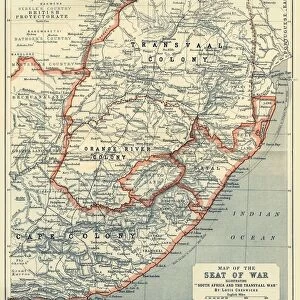
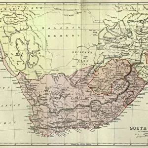
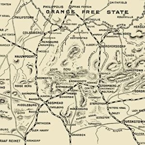
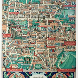
Map of the Boer Republics, 1900. Creator: Unknown

![]()
Wall Art and Photo Gifts from Heritage Images
Map of the Boer Republics, 1900. Creator: Unknown
Map of the Boer Republics, 1900. From " South Africa and the Transvaal War, Vol. I", by Louis Creswicke. [T. C. & E. C. Jack, Edinburgh, 1900]
Heritage Images features heritage image collections
Media ID 19779063
© The Print Collector/Heritage Images
Boer Boers Cape Colony Cartography Creswicke Jack Louis Louis Creswicke Map Making Mapmaking Orange Free State Republic South Africa South Africa And The Transvaal War Tc And Ec Tc And Ec Jack Transvaal
FEATURES IN THESE COLLECTIONS
> Africa
> South Africa
> Maps
> Arts
> Literature
> Books
> Arts
> Literature
> Illustration
> Arts
> Literature
> Europe
> United Kingdom
> Scotland
> Edinburgh
> Edinburgh
> Europe
> United Kingdom
> Scotland
> Lothian
> Edinburgh
EDITORS COMMENTS
This print showcases a historical treasure - the Map of the Boer Republics, 1900. Created by an unknown cartographer, this map is featured in Louis Creswicke's renowned book "South Africa and the Transvaal War, Vol. I". Published by T. C. & E. C. Jack in Edinburgh during 1900, this piece of art offers a fascinating glimpse into African geography and history. The map depicts the Boer Republics during the late 19th century, including significant locations such as South Africa, Transvaal Colony, Orange Free State, Cape Colony, and more. Its intricate details reveal not only the physical features of these regions but also their political boundaries and divisions at that time. As an illustration from a literary work on South African history and war narratives, this print holds immense cultural significance. It serves as a testament to the artistry involved in mapmaking during that era while providing valuable insights into colonial territories and conflicts. Preserved by The Print Collector organization for posterity's sake, this image reminds us of how maps have played an integral role in documenting our world throughout centuries. Whether used for navigation or understanding geopolitical landscapes, maps like these continue to captivate audiences with their beauty and historical value.
MADE IN THE UK
Safe Shipping with 30 Day Money Back Guarantee
FREE PERSONALISATION*
We are proud to offer a range of customisation features including Personalised Captions, Color Filters and Picture Zoom Tools
SECURE PAYMENTS
We happily accept a wide range of payment options so you can pay for the things you need in the way that is most convenient for you
* Options may vary by product and licensing agreement. Zoomed Pictures can be adjusted in the Basket.