Postcard > Arts > Artists > C > Juan de la Cosa
Postcard : EXPL2A-00024


![]()
Cards from North Wind
EXPL2A-00024
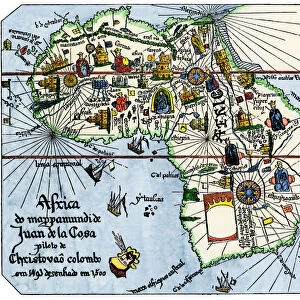
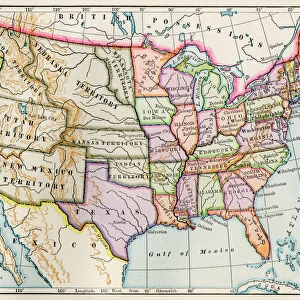
Map of the Atlantic with the New World coast, drawn in 1500 by Juan de la Cosa, Columbus pilot.
Hand colored 19th-century woodcut reproduction of the original chart
North Wind Picture Archives brings history to life with stock images and hand-colored illustrations
Media ID 5880423
© North Wind Picture Archives
1400s 15th Century 16th Century Africa Atlantic Caribbean Chart Christopher Columbus Columbus Discover Document Europe Expedition Exploration Explore Journey Maritime Navigate Navigation New World Ocean Sailing Ship Spanish Voyage West Indies 1500 Cosa Juan De La Cosa
Postcards (8 pack of A6)
Set of 8, A6 Postcards, featuring the same image on all cards in a set. Printed on 350gsm premium white satin card, the back of the postcard includes space to write messages and an area for the address and stamp. Size of each postcard is 15cm x 10.6cm.
Photo postcards are a great way to stay in touch with family and friends.
Estimated Product Size is 15cm x 10.6cm (5.9" x 4.2")
These are individually made so all sizes are approximate
Artwork printed orientated as per the preview above, with landscape (horizontal) or portrait (vertical) orientation to match the source image.
FEATURES IN THESE COLLECTIONS
> North Wind Picture Archives
> Exploration
> North Wind Picture Archives
> Maps
> Africa
> Related Images
> Arts
> Artists
> C
> Juan de la Cosa
> Arts
> Artists
> O
> Oceanic Oceanic
> Europe
> Spain
> Related Images
> Maps and Charts
> Spain
> Maps and Charts
> World
EDITORS COMMENTS
This vintage print showcases the historic Map of the Atlantic with the New World coast, meticulously drawn in 1500 by Juan de la Cosa, Christopher Columbus' trusted pilot. Hand-colored and reproduced as a woodcut in the 19th century, this exquisite chart takes us back to an era of exploration and maritime adventure. The map itself is a testament to the audacious journeys undertaken by early explorers like Columbus. It depicts not only the vastness of the Atlantic Ocean but also highlights significant regions such as the Caribbean, West Indies, Africa, Europe, and even parts of South America. Every detail on this illustration serves as a document that unravels our understanding of how these intrepid sailors navigated uncharted waters during their expeditions. As we gaze upon this remarkable piece of artistry, we are transported to an era when sailing ships ruled supreme and brave souls set out on perilous voyages to discover new lands. The intricate lines and symbols etched onto this map represent more than just geographical boundaries; they symbolize human curiosity and determination. Juan de la Cosa's contribution cannot be overstated; his expertise in navigation played a crucial role in shaping history. This print stands as a tribute to his legacy while offering us a glimpse into one of humanity's greatest achievements - exploring and mapping unknown territories
MADE IN THE UK
Safe Shipping with 30 Day Money Back Guarantee
FREE PERSONALISATION*
We are proud to offer a range of customisation features including Personalised Captions, Color Filters and Picture Zoom Tools
SECURE PAYMENTS
We happily accept a wide range of payment options so you can pay for the things you need in the way that is most convenient for you
* Options may vary by product and licensing agreement. Zoomed Pictures can be adjusted in the Basket.