Photographic Print > Animals > Mammals > Muridae > Magnus
Photographic Print : PROY2A-00017


![]()
Photo Prints from North Wind
PROY2A-00017
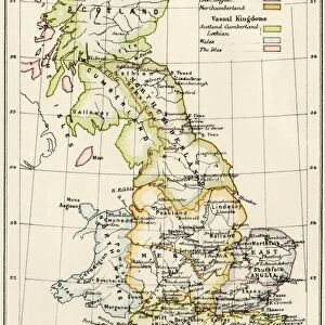
Map of Europe in the time of Charlemagne, 768-814 AD.
Printed color lithograph, 19th century
North Wind Picture Archives brings history to life with stock images and hand-colored illustrations
Media ID 5882669
© North Wind Picture Archives
700s 800s 8th Century 9th Century British Isles Empire Europe European France Great Britain Holy Roman Empire Medieval Mediterranean Sea Middle Ages North Sea Scandinavia Carolus Magnus Charlemagne Cordova
10"x8" (25x20cm) Photo Print
Discover the rich history of Europe during the time of Charlemagne with our stunning Media Storehouse Photographic Print, PROY2A-00017. This captivating 19th century color lithograph from North Wind Picture Archives transports you back to the map of Europe as it existed between 768 and 814 AD. Add this historical print to your collection and bring the intriguing tales of Charlemagne's reign into your home or office. Impress your guests with this unique and educational piece, sure to spark conversation and inspire curiosity. Order yours today!
Printed on archival quality paper for unrivalled stable artwork permanence and brilliant colour reproduction with accurate colour rendition and smooth tones. Printed on professional 234gsm Fujifilm Crystal Archive DP II paper. 10x8 for landscape images, 8x10 for portrait images.
Our Photo Prints are in a large range of sizes and are printed on Archival Quality Paper for excellent colour reproduction and longevity. They are ideal for framing (our Framed Prints use these) at a reasonable cost. Alternatives include cheaper Poster Prints and higher quality Fine Art Paper, the choice of which is largely dependant on your budget.
Estimated Product Size is 25.4cm x 20.3cm (10" x 8")
These are individually made so all sizes are approximate
Artwork printed orientated as per the preview above, with landscape (horizontal) or portrait (vertical) orientation to match the source image.
FEATURES IN THESE COLLECTIONS
> North Wind Picture Archives
> Maps
> North Wind Picture Archives
> Royals:rulers
> Animals
> Mammals
> Muridae
> Magnus
> Arts
> Art Movements
> Medieval Art
> Arts
> Artists
> R
> Roman Roman
> Historic
> Ancient civilizations
> Roman Empire
> Roman art
> Maps and Charts
> British Empire Maps
> Maps and Charts
> Related Images
EDITORS COMMENTS
This vintage print showcases a meticulously detailed map of Europe during the reign of Charlemagne, spanning from 768 to 814 AD. The stunning printed color lithograph, created in the 19th century by North Wind Picture Archives, transports us back to the medieval era with its rich historic significance. The illustration depicts an expansive view of Europe, stretching from the British Isles in the northwest to Cordova in the southwest and Slavia in the northeast. It beautifully captures key regions such as France and Scandinavia while highlighting significant bodies of water like the North Sea and Mediterranean Sea. At its center lies Charlemagne's vast empire, known as the Holy Roman Empire or Carolingian Empire. This powerful realm dominated much of Western Europe during this period and left an indelible mark on history. As we delve into this artful representation, we are transported through time to witness how kingdoms rose and fell within these borders. The map offers a glimpse into a world shaped by political alliances, cultural exchanges, and territorial conquests that defined European history throughout the Middle Ages. This remarkable piece serves not only as a visual delight but also as a valuable educational tool for understanding Europe's geopolitical landscape during one of its most influential periods.
MADE IN THE UK
Safe Shipping with 30 Day Money Back Guarantee
FREE PERSONALISATION*
We are proud to offer a range of customisation features including Personalised Captions, Color Filters and Picture Zoom Tools
SECURE PAYMENTS
We happily accept a wide range of payment options so you can pay for the things you need in the way that is most convenient for you
* Options may vary by product and licensing agreement. Zoomed Pictures can be adjusted in the Basket.