Antique Framed Print > Animals > Mammals > Muridae > Magnus
Antique Framed Print : PROY2A-00017


![]()
Framed Photos from North Wind
PROY2A-00017
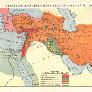
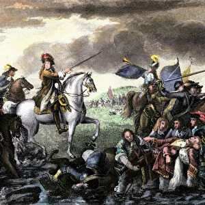
Map of Europe in the time of Charlemagne, 768-814 AD.
Printed color lithograph, 19th century
North Wind Picture Archives brings history to life with stock images and hand-colored illustrations
Media ID 5882669
© North Wind Picture Archives
700s 800s 8th Century 9th Century British Isles Empire Europe European France Great Britain Holy Roman Empire Medieval Mediterranean Sea Middle Ages North Sea Scandinavia Carolus Magnus Charlemagne Cordova
14"x12" (36x31cm) Antique Frame
Bevelled wood effect frame, card mounted, 10x8 archival quality photo print. Overall outside dimensions 14x12 inches (36x31cm). Environmentally and ozone friendly, the Polycore® moulding has the look of real wood, is durable and light and easy to hang. Biodegradable and made with non-chlorinated gases (no toxic fumes) it is efficient; producing 100 tons of polystyrene can save 300 tons of trees! Prints are glazed with lightweight, shatterproof, optical clarity acrylic (providing the same general protection from the environment as glass). The back is stapled hardboard with a sawtooth hanger attached. Note: To minimise original artwork cropping, for optimum layout, and to ensure print is secure, the visible print may be marginally smaller
Bevelled Wood Effect Framed and Mounted Prints - Professionally Made and Ready to Hang
Estimated Image Size (if not cropped) is 24.4cm x 19.5cm (9.6" x 7.7")
Estimated Product Size is 36.3cm x 31.2cm (14.3" x 12.3")
These are individually made so all sizes are approximate
Artwork printed orientated as per the preview above, with landscape (horizontal) orientation to match the source image.
FEATURES IN THESE COLLECTIONS
> Animals
> Mammals
> Muridae
> Magnus
> Arts
> Art Movements
> Medieval Art
> Arts
> Artists
> R
> Roman Roman
> Historic
> Ancient civilizations
> Roman Empire
> Roman art
> Maps and Charts
> British Empire Maps
> Maps and Charts
> Related Images
> North Wind Picture Archives
> Maps
> North Wind Picture Archives
> Royals:rulers
EDITORS COMMENTS
This vintage print showcases a meticulously detailed map of Europe during the reign of Charlemagne, spanning from 768 to 814 AD. The stunning printed color lithograph, created in the 19th century by North Wind Picture Archives, transports us back to the medieval era with its rich historic significance. The illustration depicts an expansive view of Europe, stretching from the British Isles in the northwest to Cordova in the southwest and Slavia in the northeast. It beautifully captures key regions such as France and Scandinavia while highlighting significant bodies of water like the North Sea and Mediterranean Sea. At its center lies Charlemagne's vast empire, known as the Holy Roman Empire or Carolingian Empire. This powerful realm dominated much of Western Europe during this period and left an indelible mark on history. As we delve into this artful representation, we are transported through time to witness how kingdoms rose and fell within these borders. The map offers a glimpse into a world shaped by political alliances, cultural exchanges, and territorial conquests that defined European history throughout the Middle Ages. This remarkable piece serves not only as a visual delight but also as a valuable educational tool for understanding Europe's geopolitical landscape during one of its most influential periods.
MADE IN THE UK
Safe Shipping with 30 Day Money Back Guarantee
FREE PERSONALISATION*
We are proud to offer a range of customisation features including Personalised Captions, Color Filters and Picture Zoom Tools
SECURE PAYMENTS
We happily accept a wide range of payment options so you can pay for the things you need in the way that is most convenient for you
* Options may vary by product and licensing agreement. Zoomed Pictures can be adjusted in the Basket.