Photo Mug > Europe > Republic of Ireland > Maps
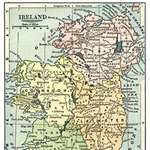
Photo Mug : MAP: IRELAND, 1851. An engraved map of Ireland, 1851


![]()
Home Decor from Granger
MAP: IRELAND, 1851. An engraved map of Ireland, 1851
Granger holds millions of images spanning more than 25,000 years of world history, from before the Stone Age to the dawn of the Space Age
Media ID 7514075
Photo Mug
Introducing the Media Storehouse Photo Mug featuring a captivating historical image of "MAP: IRELAND, 1851. An engraved map of Ireland, 1851" from The Granger Collection. This unique mug is not just a drinkware, it's a time machine. Sip your favorite beverage while immersing yourself in the intricate details of this engraved map of Ireland, dated back to 1851. Each sip brings you closer to history, making every moment a journey. This high-quality mug is perfect for history buffs, Irish heritage enthusiasts, or anyone who appreciates the beauty of vintage maps. Embrace the past, one sip at a time.
A personalised photo mug blends sentimentality with functionality, making an ideal gift for cherished loved ones, close friends, or valued colleagues. Preview may show both sides of the same mug.
Elevate your coffee or tea experience with our premium white ceramic mug. Its wide, comfortable handle makes drinking easy, and you can rely on it to be both microwave and dishwasher safe. Sold in single units, preview may show both sides of the same mug so you can see how the picture wraps around.
Mug Size is 9.5cm high x 8cm diameter (3.7" x 3.1")
These are individually made so all sizes are approximate
FEATURES IN THESE COLLECTIONS
> Granger Art on Demand
> Maps
> Europe
> Republic of Ireland
> Maps
> Maps and Charts
> Related Images
EDITORS COMMENTS
This print showcases an exquisite engraved map of Ireland from the year 1851. The intricate details and craftsmanship of this historical artifact transport us back to a time when cartography was both an art form and a vital tool for exploration. Every line, curve, and contour on this map tells a story of Ireland's rich history and geography. The middle section of the map captures the essence of Ireland with its lush green landscapes, rolling hills, and meandering rivers. It offers a glimpse into the country's diverse topography that has shaped its culture over centuries. As our eyes wander across the engraving, we can almost feel ourselves traversing through Irish towns and villages nestled along these winding waterways. Beyond its aesthetic appeal, this engraved map holds immense historical significance. It serves as a window into 19th-century Ireland – a period marked by political unrest, famine, and cultural revival. This piece is not just about geographical boundaries; it encapsulates the spirit of resilience embodied by the Irish people during challenging times. Thanks to Granger Art on Demand's meticulous preservation efforts, we are fortunate to have access to such remarkable artifacts like this one. Whether you are an avid historian or simply appreciate fine artistry, this print is sure to captivate your imagination while offering insights into Ireland's past like never before.
MADE IN THE UK
Safe Shipping with 30 Day Money Back Guarantee
FREE PERSONALISATION*
We are proud to offer a range of customisation features including Personalised Captions, Color Filters and Picture Zoom Tools
SECURE PAYMENTS
We happily accept a wide range of payment options so you can pay for the things you need in the way that is most convenient for you
* Options may vary by product and licensing agreement. Zoomed Pictures can be adjusted in the Basket.