Framed Print > Europe > Republic of Ireland > Maps
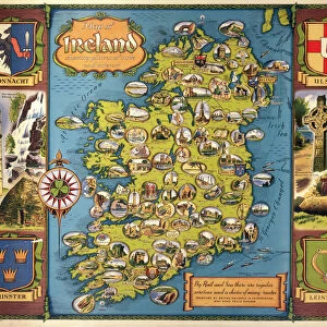
Framed Print : MAP: IRELAND, 1851. An engraved map of Ireland, 1851


![]()
Framed Photos from Granger
MAP: IRELAND, 1851. An engraved map of Ireland, 1851
Granger holds millions of images spanning more than 25,000 years of world history, from before the Stone Age to the dawn of the Space Age
Media ID 7514075
14"x12" (38x32cm) Modern Frame
Discover the rich history of Ireland with our stunning Framed Print of "MAP: IRELAND, 1851" from Media Storehouse and The Granger Collection. This captivating engraved map, originally from Granger Art on Demand, offers a glimpse into the past with intricate detail and vintage charm. Travel back in time as you explore the intricacies of Ireland's geography from 1851. Add this beautiful piece to your home or office decor to start a conversation about history and cartography. A perfect addition to any room, our high-quality framed print will surely be a conversation starter and a cherished piece in your collection.
Wood effect frame, card mounted, 10x8 archival quality photo print. Overall outside dimensions 14x12 inches (38x32cm). Environmentally and ozone friendly, 40mm wide x 15mm Polycore® moulding has the look of real wood, is durable and light and easy to hang. Biodegradable and made with non-chlorinated gases (no toxic fumes) it is efficient; producing 100 tons of polystyrene can save 300 tons of trees! Prints are glazed with lightweight, shatterproof, optical clarity acrylic (providing the same general protection from the environment as glass). The back is stapled hardboard with a sawtooth hanger attached. Note: To minimise original artwork cropping, for optimum layout, and to ensure print is secure, the visible print may be marginally smaller
Contemporary Framed and Mounted Prints - Professionally Made and Ready to Hang
Estimated Image Size (if not cropped) is 16.9cm x 24.4cm (6.7" x 9.6")
Estimated Product Size is 32.5cm x 37.6cm (12.8" x 14.8")
These are individually made so all sizes are approximate
Artwork printed orientated as per the preview above, with portrait (vertical) orientation to match the source image.
FEATURES IN THESE COLLECTIONS
> Europe
> Republic of Ireland
> Maps
> Maps and Charts
> Related Images
> Granger Art on Demand
> Maps
EDITORS COMMENTS
This print showcases an exquisite engraved map of Ireland from the year 1851. The intricate details and craftsmanship of this historical artifact transport us back to a time when cartography was both an art form and a vital tool for exploration. Every line, curve, and contour on this map tells a story of Ireland's rich history and geography. The middle section of the map captures the essence of Ireland with its lush green landscapes, rolling hills, and meandering rivers. It offers a glimpse into the country's diverse topography that has shaped its culture over centuries. As our eyes wander across the engraving, we can almost feel ourselves traversing through Irish towns and villages nestled along these winding waterways. Beyond its aesthetic appeal, this engraved map holds immense historical significance. It serves as a window into 19th-century Ireland – a period marked by political unrest, famine, and cultural revival. This piece is not just about geographical boundaries; it encapsulates the spirit of resilience embodied by the Irish people during challenging times. Thanks to Granger Art on Demand's meticulous preservation efforts, we are fortunate to have access to such remarkable artifacts like this one. Whether you are an avid historian or simply appreciate fine artistry, this print is sure to captivate your imagination while offering insights into Ireland's past like never before.
MADE IN THE UK
Safe Shipping with 30 Day Money Back Guarantee
FREE PERSONALISATION*
We are proud to offer a range of customisation features including Personalised Captions, Color Filters and Picture Zoom Tools
SECURE PAYMENTS
We happily accept a wide range of payment options so you can pay for the things you need in the way that is most convenient for you
* Options may vary by product and licensing agreement. Zoomed Pictures can be adjusted in the Basket.