Mouse Mat > Arts > Artists > B > Jan Blaeu
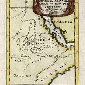
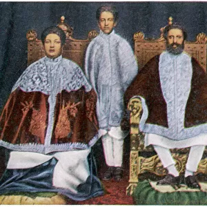
Mouse Mat : ATLAS: EAST AFRICA, 1665. Map of Ethiopia (kingdom of Prester John), Abyssinia, and Arabia, from Jan Blaeus Atlas Maior, printed in Amsterdam, 1665
, Abyssinia, and Arabia, from Jan Blaeus Atlas Maior, printed in Amsterdam, 1665")


![]()
Home Decor from Granger
ATLAS: EAST AFRICA, 1665. Map of Ethiopia (kingdom of Prester John), Abyssinia, and Arabia, from Jan Blaeus Atlas Maior, printed in Amsterdam, 1665
Granger holds millions of images spanning more than 25,000 years of world history, from before the Stone Age to the dawn of the Space Age
Media ID 7556663
1665 African Blaeu Cartouche Coast Dutch East Africa Family Father Indian Ocean Janszoon Johann Johannes Mother Parasol Prester Red Sea Saudi Arabia Turban Abyssin Ia Atlas Maior Mozambique
Mouse Mat
A high quality photographic print manufactured into a durable wipe clean mouse mat (27x22cm) with a non slip backing, which works with all mice.
Archive quality photographic print in a durable wipe clean mouse mat with non slip backing. Works with all computer mice
Estimated Image Size (if not cropped) is 15.9cm x 25.4cm (6.3" x 10")
Estimated Product Size is 21.8cm x 26.9cm (8.6" x 10.6")
These are individually made so all sizes are approximate
Artwork printed orientated as per the preview above, with portrait (vertical) orientation to match the source image.
FEATURES IN THESE COLLECTIONS
> Africa
> Ethiopia (Abyssinia)
> Maps
> Africa
> Ethiopia (Abyssinia)
> Related Images
> Africa
> Ethiopia
> Related Images
> Africa
> Mozambique
> Maps
> Africa
> Mozambique
> Related Images
> Arts
> Artists
> B
> Jan Blaeu
> Arts
> Artists
> O
> Oceanic Oceanic
> Asia
> Saudi Arabia
> Maps
> Asia
> Saudi Arabia
> Related Images
EDITORS COMMENTS
This print takes us back in time to the year 1665, showcasing a beautifully detailed map of East Africa. The focus lies on Ethiopia, also known as the kingdom of Prester John, and Abyssinia, surrounded by the Arabian Peninsula. Printed in Amsterdam by Jan Blaeu for his renowned Atlas Maior, this piece is a true testament to the artistry and precision of cartography during that era. The image transports us to an age when exploration was at its peak, with Dutch sailors venturing into uncharted territories across distant seas. The sun shines brightly overhead as it illuminates the vast coastline stretching from Mozambique to Saudi Arabia. A family stands proudly beside their parasol, dressed in traditional African attire adorned with turbans. Engraved with intricate details and delicate lines, this map offers a glimpse into the cultural richness of East Africa during that time period. It features rivers meandering through lush landscapes while ships sail along the Indian Ocean and Red Sea trade routes. Intriguingly placed within a decorative cartouche are portraits of Johann Janszoon Blaeu himself alongside an Ethiopian man and woman – perhaps representing local inhabitants encountered during his travels. This inclusion adds depth and humanity to an otherwise technical representation. Overall, this print captures not only historical significance but also evokes a sense of wonderment about our world's past explorations and connections between different cultures.
MADE IN THE UK
Safe Shipping with 30 Day Money Back Guarantee
FREE PERSONALISATION*
We are proud to offer a range of customisation features including Personalised Captions, Color Filters and Picture Zoom Tools
SECURE PAYMENTS
We happily accept a wide range of payment options so you can pay for the things you need in the way that is most convenient for you
* Options may vary by product and licensing agreement. Zoomed Pictures can be adjusted in the Basket.