Mounted Print > Arts > Artists > J > Thomas Jefferys
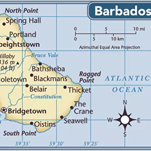
Mounted Print : CARIBBEAN: MAP, 1775. English engraved map of The Caribee Islands from Puerto Rico to Barbados by Thomas Jefferys, 1775


![]()
Mounted Prints from Granger
CARIBBEAN: MAP, 1775. English engraved map of The Caribee Islands from Puerto Rico to Barbados by Thomas Jefferys, 1775
Granger holds millions of images spanning more than 25,000 years of world history, from before the Stone Age to the dawn of the Space Age
Media ID 7563845
1775 Caribbean Carribean Colony Geography Island Latin America Navigation Portolan Chart Puerto Rico Virgin Islands West Indies Antilles Windward
10"x8" Mount with 8"x6" Print
Step back in time with our exquisite mounted photo of the English engraved map of the Caribbees, dated 1775 by Thomas Jefferys. This captivating piece, sourced from The Granger Collection at Granger Art on Demand, showcases an intricate and detailed depiction of the islands from Puerto Rico to Barbados. Perfectly preserved, this vintage map adds an air of history and charm to any room. Display it proudly as a conversation starter or a decorative accent. Bring the rich maritime history of the Caribbean into your home with our high-quality mounted photo of this rare and intriguing map.
Printed on 8"x6" paper and suitable for use in a 10"x8" frame (frame not included). Prints are mounted with card both front and back. Featuring a custom cut aperture to match chosen image. Professional 234gsm Fujifilm Crystal Archive DP II paper.
Photo prints supplied in custom cut card mount ready for framing
Estimated Image Size (if not cropped) is 19.7cm x 15.2cm (7.8" x 6")
Estimated Product Size is 25.4cm x 20.3cm (10" x 8")
These are individually made so all sizes are approximate
Artwork printed orientated as per the preview above, with landscape (horizontal) orientation to match the source image.
FEATURES IN THESE COLLECTIONS
> Arts
> Artists
> J
> Thomas Jefferys
> Maps and Charts
> Related Images
> North America
> Barbados
> Maps
> North America
> Barbados
> Related Images
> North America
> Puerto Rico
> Maps
> North America
> Puerto Rico
> Related Images
> North America
> US Virgin Islands
> Maps
EDITORS COMMENTS
This print showcases an exquisite English engraved map of the Caribee Islands, dating back to 1775. Created by the talented cartographer Thomas Jefferys, this late 18th-century masterpiece offers a fascinating glimpse into the geography and navigation of the Caribbean region. The intricate details on this nautical map stretch from Puerto Rico to Barbados, encompassing various islands such as Antilles, Virgin Islands, and Windward. It serves as a testament to the rich colonial history that shaped these lands in Latin America. Engraved with utmost precision and artistry, this vintage piece is not only a visual delight but also a valuable historical artifact. Its inclusion in The Granger Collection's Carousel Collection further highlights its significance as it represents an era when portolan charts played a vital role in maritime exploration. As you immerse yourself in this remarkable print, allow your imagination to wander through time and space. Picture sailors relying on maps like these to navigate treacherous waters while discovering new territories within the West Indies. Let it transport you back to an age where adventure awaited at every turn. Whether you are an avid historian or simply appreciate fine art, this print is sure to captivate your senses and spark curiosity about the enchanting world of Caribbean exploration.
MADE IN THE UK
Safe Shipping with 30 Day Money Back Guarantee
FREE PERSONALISATION*
We are proud to offer a range of customisation features including Personalised Captions, Color Filters and Picture Zoom Tools
SECURE PAYMENTS
We happily accept a wide range of payment options so you can pay for the things you need in the way that is most convenient for you
* Options may vary by product and licensing agreement. Zoomed Pictures can be adjusted in the Basket.