Framed Print > Arts > Artists > J > Thomas Jefferys
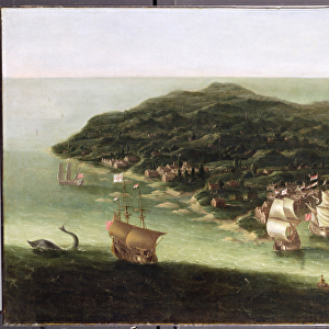
Framed Print : CARIBBEAN: MAP, 1775. English engraved map of The Caribee Islands from Puerto Rico to Barbados by Thomas Jefferys, 1775


![]()
Framed Photos from Granger
CARIBBEAN: MAP, 1775. English engraved map of The Caribee Islands from Puerto Rico to Barbados by Thomas Jefferys, 1775
Granger holds millions of images spanning more than 25,000 years of world history, from before the Stone Age to the dawn of the Space Age
Media ID 7563845
1775 Caribbean Carribean Colony Geography Island Latin America Navigation Portolan Chart Puerto Rico Virgin Islands West Indies Antilles Windward
14"x12" (38x32cm) Modern Frame
Travel back in time with our stunning Framed Print from Media Storehouse, featuring the English engraved map of The Caribbees Islands from Puerto Rico to Barbados by Thomas Jefferys, dated 1775. This exquisite piece, sourced from The Granger Collection at Granger Art on Demand, offers a captivating glimpse into the historical cartography of the Caribbean region. The intricate details of the map are brought to life with our high-quality framing, making it an essential addition to any home or office space. Transport yourself to the past and add a touch of history to your décor with this beautiful Framed Print.
Wood effect frame, card mounted, 10x8 archival quality photo print. Overall outside dimensions 14x12 inches (38x32cm). Environmentally and ozone friendly, 40mm wide x 15mm Polycore® moulding has the look of real wood, is durable and light and easy to hang. Biodegradable and made with non-chlorinated gases (no toxic fumes) it is efficient; producing 100 tons of polystyrene can save 300 tons of trees! Prints are glazed with lightweight, shatterproof, optical clarity acrylic (providing the same general protection from the environment as glass). The back is stapled hardboard with a sawtooth hanger attached. Note: To minimise original artwork cropping, for optimum layout, and to ensure print is secure, the visible print may be marginally smaller
Contemporary Framed and Mounted Prints - Professionally Made and Ready to Hang
Estimated Image Size (if not cropped) is 24.4cm x 18.8cm (9.6" x 7.4")
Estimated Product Size is 37.6cm x 32.5cm (14.8" x 12.8")
These are individually made so all sizes are approximate
Artwork printed orientated as per the preview above, with landscape (horizontal) orientation to match the source image.
FEATURES IN THESE COLLECTIONS
> Arts
> Artists
> J
> Thomas Jefferys
> Maps and Charts
> Related Images
> North America
> Barbados
> Maps
> North America
> Barbados
> Related Images
> North America
> Puerto Rico
> Maps
> North America
> Puerto Rico
> Related Images
> North America
> US Virgin Islands
> Maps
EDITORS COMMENTS
This print showcases an exquisite English engraved map of the Caribee Islands, dating back to 1775. Created by the talented cartographer Thomas Jefferys, this late 18th-century masterpiece offers a fascinating glimpse into the geography and navigation of the Caribbean region. The intricate details on this nautical map stretch from Puerto Rico to Barbados, encompassing various islands such as Antilles, Virgin Islands, and Windward. It serves as a testament to the rich colonial history that shaped these lands in Latin America. Engraved with utmost precision and artistry, this vintage piece is not only a visual delight but also a valuable historical artifact. Its inclusion in The Granger Collection's Carousel Collection further highlights its significance as it represents an era when portolan charts played a vital role in maritime exploration. As you immerse yourself in this remarkable print, allow your imagination to wander through time and space. Picture sailors relying on maps like these to navigate treacherous waters while discovering new territories within the West Indies. Let it transport you back to an age where adventure awaited at every turn. Whether you are an avid historian or simply appreciate fine art, this print is sure to captivate your senses and spark curiosity about the enchanting world of Caribbean exploration.
MADE IN THE UK
Safe Shipping with 30 Day Money Back Guarantee
FREE PERSONALISATION*
We are proud to offer a range of customisation features including Personalised Captions, Color Filters and Picture Zoom Tools
SECURE PAYMENTS
We happily accept a wide range of payment options so you can pay for the things you need in the way that is most convenient for you
* Options may vary by product and licensing agreement. Zoomed Pictures can be adjusted in the Basket.