Mounted Print > Europe > United Kingdom > Northern Ireland > Maps
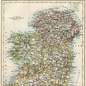
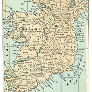
Mounted Print : Map of Ireland 1897


![]()
Mounted Prints from Fine Art Storehouse
Map of Ireland 1897
Map of Ireland
Unleash your creativity and transform your space into a visual masterpiece!
THEPALMER
Media ID 13613567
© Roberto A Sanchez
62990 Atlas Earth Globe Navigational Equipment Irish Culture Northern Ireland Paper Republic Of Ireland World Map Retro Styled
10"x8" Mount with 8"x6" Print
Printed on 8"x6" paper and suitable for use in a 10"x8" frame (frame not included). Prints are mounted with card both front and back. Featuring a custom cut aperture to match chosen image. Professional 234gsm Fujifilm Crystal Archive DP II paper.
Photo prints supplied in custom cut card mount ready for framing
Estimated Image Size (if not cropped) is 15.2cm x 19.8cm (6" x 7.8")
Estimated Product Size is 20.3cm x 25.4cm (8" x 10")
These are individually made so all sizes are approximate
Artwork printed orientated as per the preview above, with portrait (vertical) orientation to match the source image.
FEATURES IN THESE COLLECTIONS
> Fine Art Storehouse
> The Magical World of Illustration
> Palmer Illustrated Collection
> Fine Art Storehouse
> Map
> Historical Maps
> Fine Art Storehouse
> Top Sellers - Art Prints
> Europe
> Related Images
> Europe
> Republic of Ireland
> Maps
> Europe
> Republic of Ireland
> Related Images
> Europe
> United Kingdom
> Maps
> Europe
> United Kingdom
> Northern Ireland
> Maps
> Europe
> United Kingdom
> Northern Ireland
> Posters
> Europe
> United Kingdom
> Northern Ireland
> Related Images
> Maps and Charts
> Popular Maps
> Maps and Charts
> Related Images
> Maps and Charts
> World
EDITORS COMMENTS
This print of the "Map of Ireland 1897" takes us on a nostalgic journey through time, offering a glimpse into the rich history and cultural heritage of this enchanting island. With its retro-styled cartography and antique engraved image, it exudes an air of elegance that transports us back to a bygone era. The intricate details captured in this engraving showcase the physical geography of Ireland, highlighting its diverse landscapes and geographical features. From the rugged coastlines to rolling hills and lush green fields, every contour is meticulously depicted, inviting us to explore the beauty that lies within. As we delve deeper into this vintage map, our eyes are drawn to Northern Ireland and the Republic of Ireland - two distinct regions with their own unique identities yet intrinsically linked by their shared Irish culture. This serves as a reminder of the complex historical context surrounding these lands. Displayed in vertical format without any people present, this piece allows us to focus solely on the magnificence of Earth's natural wonders. The inclusion of globe navigational equipment further emphasizes our connection with exploration and discovery. Photographed in 2015 by THEPALMER for Fine Art Storehouse, this stunning print captures not only a moment frozen in time but also invites contemplation about how our world has evolved since then. It serves as both an educational tool for understanding past geographies while also serving as an exquisite piece of art that can be admired for years to come.
MADE IN THE UK
Safe Shipping with 30 Day Money Back Guarantee
FREE PERSONALISATION*
We are proud to offer a range of customisation features including Personalised Captions, Color Filters and Picture Zoom Tools
SECURE PAYMENTS
We happily accept a wide range of payment options so you can pay for the things you need in the way that is most convenient for you
* Options may vary by product and licensing agreement. Zoomed Pictures can be adjusted in the Basket.