Metal Print > Arts > Artists > O > Oceanic Oceanic
Metal Print : EXPL2A-00065


![]()
Metal Prints from North Wind
EXPL2A-00065
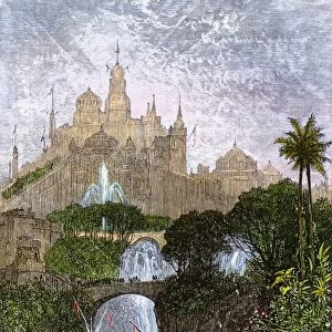
World map of the flat earth printed by Beatus Rhenanus Bildaus Rheinau early 1500s - North is left, Mediterranean Sea middle
Printed color lithograph reproduction 19th century
North Wind Picture Archives brings history to life with stock images and hand-colored illustrations
Media ID 5882012
© North Wind Picture Archives
1500s 16th Century Adventure Africa Asia Atlantic Ocean Cartography Chart Discover Europe Exploration Explore Fish Flat Earth Maritime Mediterranean Mediterranean Sea Navigation Ocean Travel World Beatus Libia Libya
15"x10" (38x25cm) Metal Print
Discover the captivating allure of history with Media Storehouse's Metal Prints. Feast your eyes on this extraordinary reproduction of EXPL2A-00065 from North Wind Picture Archives. This mesmerizing print showcases a rare 15th-century world map, created by Beatus Rhenanus at Rheinau. With intricate detail and vibrant colors, this lithograph transports you back in time. Our high-quality Metal Prints not only bring your chosen image to life but also add a modern and stylish touch to any space. Embrace the past and the present with this unique and intriguing addition to your home or office decor.
Your image is printed photographically and bonded to a 3.5mm thick, Dibond board (black polyethylene sandwiched between two sheets of white coated aluminium). The panel is then sealed with a gloss protective covering. Supplied complete with a wall mount which holds the print 10mm from the wall.
Made with durable metal and luxurious printing techniques, metal prints bring images to life and add a modern touch to any space
Estimated Product Size is 38.1cm x 25.4cm (15" x 10")
These are individually made so all sizes are approximate
Artwork printed orientated as per the preview above, with landscape (horizontal) or portrait (vertical) orientation to match the source image.
FEATURES IN THESE COLLECTIONS
> Africa
> Libya
> Related Images
> Africa
> Related Images
> Animals
> Fishes
> Related Images
> Arts
> Artists
> O
> Oceanic Oceanic
> Asia
> Related Images
> Maps and Charts
> Early Maps
> Maps and Charts
> Flat Earth
> Maps and Charts
> Related Images
> North Wind Picture Archives
> Maps
EDITORS COMMENTS
This vintage print takes us back to the early 1500s when cartography was still in its infancy. Titled "EXPL2A-00065" it showcases a world map of the flat earth, printed by Beatus Rhenanus Bildaus Rheinau. The unique aspect of this map is that North is depicted on the left side, contrary to our modern conventions. The Mediterranean Sea occupies the central position, serving as a pivotal point for navigation and trade routes during that era. The lithograph reproduction from the 19th century beautifully captures the intricate details and vibrant colors of the original artwork. As we explore this historic illustration, we can't help but notice various elements that reflect both adventure and maritime culture. Fish swim gracefully through oceans while ships sail across vast waters, symbolizing exploration and discovery. The chart encompasses Africa, Asia, Europe, and even Libya (Libia), providing a glimpse into how these regions were perceived at that time. It offers an intriguing insight into early cartography techniques and highlights how knowledge about our planet has evolved over centuries. This artful depiction serves as a reminder of humanity's curiosity about the world around us throughout history. Whether used for educational purposes or simply admired for its aesthetic appeal, this print invites us to embark on a journey through time where imagination meets reality.
MADE IN THE UK
Safe Shipping with 30 Day Money Back Guarantee
FREE PERSONALISATION*
We are proud to offer a range of customisation features including Personalised Captions, Color Filters and Picture Zoom Tools
SECURE PAYMENTS
We happily accept a wide range of payment options so you can pay for the things you need in the way that is most convenient for you
* Options may vary by product and licensing agreement. Zoomed Pictures can be adjusted in the Basket.