Metal Print > Arts > Artists > C > Juan de la Cosa
Metal Print : Chart by Juan de la Cosa (1450-1510). Spain. Madrid. Mavy Mu
. Spain. Madrid. Mavy Mu")


![]()
Metal Prints from Mary Evans Picture Library
Chart by Juan de la Cosa (1450-1510). Spain. Madrid. Mavy Mu
Chart by Juan de la Cosa (1450-1510). Spain. Madrid. Mavy Museum
Mary Evans Picture Library makes available wonderful images created for people to enjoy over the centuries
Media ID 14337268
© Thaliastock / Mary Evans
Americas Biscayan Cartographer Cartography Chart Cosa Earliest Juan Mundi Museo Navigation Navigator Parchment 15th Mappa
15"x10" (38x25cm) Metal Print
Bring the rich history of cartography to your home or office with our Media Storehouse Metal Prints. Featuring the intricate and captivating Chart by Juan de la Cosa (1450-1510), this exquisite piece showcases the detailed exploration routes of the Spanish and Portuguese navigators during the Age of Discovery. Meticulously sourced from the Mavy Museum in Madrid through Mary Evans Prints Online, this rights-managed image is now available in a stunning metal print format. The vibrant colors and sharp details of the chart are beautifully preserved, making it a true conversation starter and a beautiful addition to any space. Order your Juan de la Cosa Metal Print today and let the adventure begin!
Your image is printed photographically and bonded to a 3.5mm thick, Dibond board (black polyethylene sandwiched between two sheets of white coated aluminium). The panel is then sealed with a gloss protective covering. Supplied complete with a wall mount which holds the print 10mm from the wall.
Made with durable metal and luxurious printing techniques, metal prints bring images to life and add a modern touch to any space
Estimated Product Size is 38.1cm x 25.4cm (15" x 10")
These are individually made so all sizes are approximate
Artwork printed orientated as per the preview above, with landscape (horizontal) or portrait (vertical) orientation to match the source image.
EDITORS COMMENTS
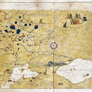
This stunning chart, created by the Spanish cartographer Juan de la Cosa around 1500, is one of the earliest known European maps to depict both the Americas and Africa. Known as the "Mapy-Mapy" or "Mappa Mundi of Juan de la Cosa," this parchment map measures approximately 1.3 meters in diameter and was likely used for naval navigation. Born in the Basque region of Spain around 1450, Juan de la Cosa was a skilled navigator and cartographer who made significant contributions to the emerging field of cartography during the Age of Discovery. His chart is notable for its detailed representation of the known world at the time, including the western coasts of Europe, the Mediterranean Sea, the Atlantic Ocean, and the eastern coasts of North and South America. The map was discovered in the late 19th century in the Royal Archives of Madrid and is now housed in the Mavy Museum in Madrid, Spain. It is believed to have been created around 1500, making it an important artifact from the Middle Ages and a valuable resource for historians and scholars studying the history of cartography and European exploration. The map is also notable for its intricate and colorful decorative elements, which include illustrations of various mythical creatures, sea monsters, and exotic animals from different parts of the world. These elements reflect the fascination and curiosity of Europeans during the Age of Discovery, as they explored new lands and encountered new cultures and peoples. Overall, the Mapy-Mapy of Juan de la Cosa is a remarkable piece of cartographic history, providing valuable insights into the worldview of Europeans during the late 15th century and the early modern age. Its intricate details and decorative elements continue to captivate and inspire scholars and visitors alike, making it a must-see attraction at the Mavy Museum in Madrid.
MADE IN THE UK
Safe Shipping with 30 Day Money Back Guarantee
FREE PERSONALISATION*
We are proud to offer a range of customisation features including Personalised Captions, Color Filters and Picture Zoom Tools
SECURE PAYMENTS
We happily accept a wide range of payment options so you can pay for the things you need in the way that is most convenient for you
* Options may vary by product and licensing agreement. Zoomed Pictures can be adjusted in the Basket.