Home > Europe > United Kingdom > Wales > Maps
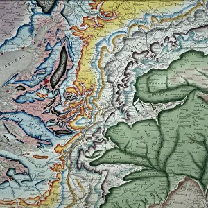
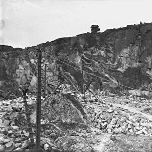
William Smiths geological table

![]()
Wall Art and Photo Gifts from Mary Evans Picture Library
William Smiths geological table
Fig 2 from Delineation of Strata of England and Wales (1815) by William Smith
Mary Evans Picture Library makes available wonderful images created for people to enjoy over the centuries
Media ID 8580081
© Mary Evans Picture Library 2015 - https://copyrighthub.org/s0/hub1/creation/maryevans/MaryEvansPictureID/10706287
1769 1839 Geological Geology Great Britain Strata Stratification William Smith Smith
FEATURES IN THESE COLLECTIONS
> Europe
> United Kingdom
> England
> Maps
> Europe
> United Kingdom
> Wales
> Maps
> Maps and Charts
> Geological Map
> Maps and Charts
> Wales
EDITORS COMMENTS
1. Title: A Visionary Leap in Geological Understanding: William Smith's Groundbreaking Geological Table (1815) Fig. 2, taken from William Smith's seminal work "Delineation of Strata of England and Wales," presents a captivating and historically significant image: the Geological Table. Born in 1769, Smith is celebrated as the "Father of English Geology," and this table is a testament to his revolutionary insights into the stratification of rocks and the geological history of England and Wales. Smith's Geological Table, depicted in vibrant colours, is a visual representation of the various rock strata, arranged in order from oldest to youngest. This innovative approach to understanding the Earth's geological past was a radical departure from the prevailing views of his time. Smith's meticulous observations and deductions, based on the fossils and rock formations he encountered during his extensive travels, paved the way for the modern science of geology. The table spans from the oldest Silurian and Ordovician strata to the younger Triassic and Jurassic formations. Each stratum is identified by a unique key, which corresponds to the specific rock types and fossils found within. The intricate details of the table reveal the complex interplay of geological events that shaped the landscape of Great Britain, offering a fascinating glimpse into Europe's geological past. This image, a powerful symbol of the intellectual journey that transformed our understanding of the Earth, is a testament to Smith's unwavering curiosity and his ability to connect the dots between seemingly disparate observations. The Geological Table remains an enduring legacy of Smith's groundbreaking work, inspiring generations of geologists and contributing to our ever-evolving knowledge of the natural world.
MADE IN THE UK
Safe Shipping with 30 Day Money Back Guarantee
FREE PERSONALISATION*
We are proud to offer a range of customisation features including Personalised Captions, Color Filters and Picture Zoom Tools
SECURE PAYMENTS
We happily accept a wide range of payment options so you can pay for the things you need in the way that is most convenient for you
* Options may vary by product and licensing agreement. Zoomed Pictures can be adjusted in the Basket.