Home > Europe > Lithuania > Maps
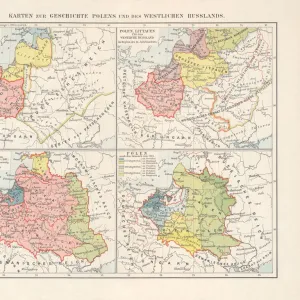
1771, Zannoni Map of Poland and Lithuania, topography, cartography, geography, land

![]()
Wall Art and Photo Gifts from Liszt Collection
1771, Zannoni Map of Poland and Lithuania, topography, cartography, geography, land
1771, Zannoni Map of Poland and Lithuania
Liszt Collection of nineteenth-century engravings and images to browse and enjoy
Media ID 14006718
© Artokoloro Quint Lox Limited
1771 Antique Map Atlas Chart Geographic Latitude Longitude Mappa Mundi Old Antique Plan Old Antique View Old Map Ols Antique Map Rare Old Maps Topo
FEATURES IN THESE COLLECTIONS
> Maps and Charts
> Early Maps
> Maps and Charts
> World
EDITORS COMMENTS
This print showcases the remarkable "1771, Zannoni Map of Poland and Lithuania". A true masterpiece in topography, cartography, and geography, this vintage map takes us on a journey through time. Its intricate details beautifully illustrate the vast lands of Poland and Lithuania with precision. The artistry behind this historic piece is evident in its carefully drawn lines that form a grid of latitude and longitude. The geometric patterns create an aesthetic appeal while serving as navigational aids for explorers of old. This ancient map holds immense historical significance, offering glimpses into the past when travel and discovery were at their peak. Printed on aged paper, it exudes an air of authenticity that transports us back to a bygone era. The decorative elements add charm to its already enchanting nature. As we gaze upon this rare gem from the Liszt Collection, we cannot help but marvel at how it encapsulates not only the geographical features but also the spirit of exploration that defined those times. With every glance at this mappa mundi representation, we are reminded of our connection to history and our place within a larger world. It serves as a reminder that even though centuries have passed since its creation, maps continue to be essential tools for understanding our planet's diverse regions.
MADE IN THE UK
Safe Shipping with 30 Day Money Back Guarantee
FREE PERSONALISATION*
We are proud to offer a range of customisation features including Personalised Captions, Color Filters and Picture Zoom Tools
SECURE PAYMENTS
We happily accept a wide range of payment options so you can pay for the things you need in the way that is most convenient for you
* Options may vary by product and licensing agreement. Zoomed Pictures can be adjusted in the Basket.