
Lithuania Collection
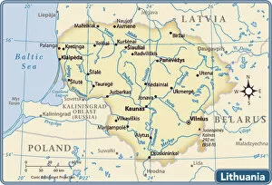
Lithuania is a country located in Northern Europe, bordered by Latvia to the north, Belarus to the east and south, Poland to the south
Choose a picture from our Lithuania Collection for your Wall Art and Photo Gifts
70 items


All Professionally Made to Order for Quick Shipping
-
Lithuania Collection
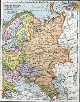
Lithuania is a country located in Northern Europe, bordered by Latvia to the north, Belarus to the east and south, Poland to the south, and Russia's Kaliningrad Oblast to the southwest. The country has a population of approximately 2.8 million people and covers an area of 65,300 square kilometers. Lithuania's capital city is Vilnius, which is also its largest city. The official language spoken is Lithuanian. The country has a diverse economy with industries such as agriculture, manufacturing, and services contributing significantly to its GDP. Lithuania has several natural resources such as peat deposits and forests that are used for commercial purposes.
+
Our beautiful pictures are available as Framed Prints, Photos, Wall Art and Photo Gifts
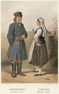
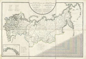
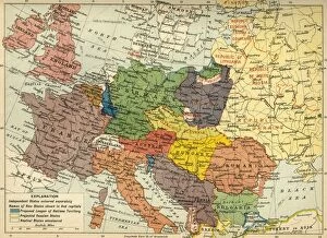
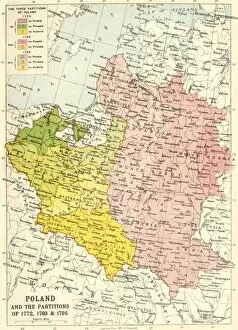
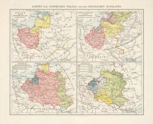
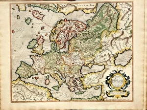
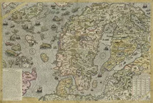
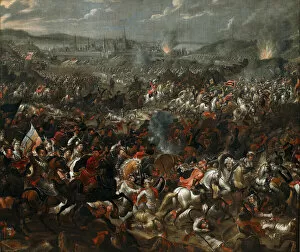
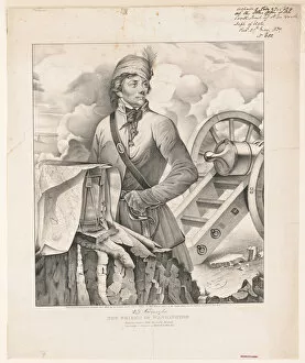
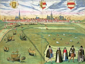
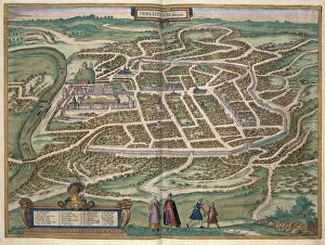
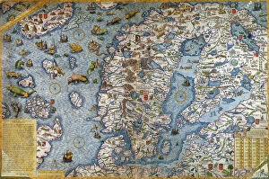
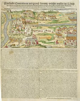
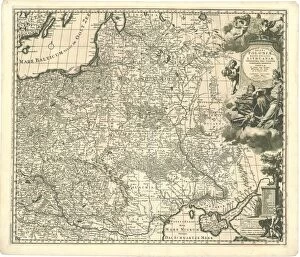
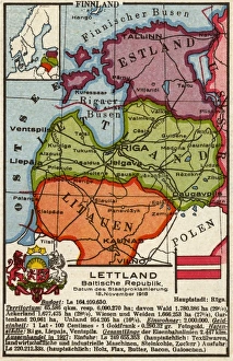
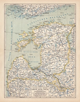
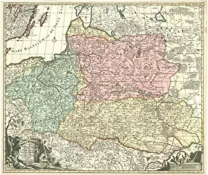
The Lithuania collection from Media Storehouse is a stunning compilation of vintage maps and charts that showcase the country's rich history, culture, and geography. Our collection features lithographs, engravings, and illustrations dating back to the 16th century, depicting various regions of Lithuania in intricate detail. From antique maps showcasing the topography of Vilnius to historical charts highlighting trade routes across the Baltic Sea, our collection offers a unique glimpse into Lithuania's past. The prints are available in a variety of sizes and formats including canvas prints, framed prints, and posters. Whether you're an art collector or simply looking for beautiful wall decor with cultural significance, the Lithuania collection from Media Storehouse has something for everyone. These timeless pieces are perfect for adding character to any room while also serving as educational tools that tell stories about Lithuania's fascinating past.
+
What are Lithuania (Maps and Charts) art prints?
Lithuania art prints are high-quality reproductions of vintage maps and charts depicting Lithuania's geography, history, and culture. These art prints showcase the intricate details of old maps that were used for navigation, exploration, or education in the past. They feature various styles such as antique lithographs, engravings, and hand-drawn illustrations that capture the essence of Lithuania's rich heritage. These Lithuanian map art prints are perfect for those who appreciate historical artifacts or have a special connection to Lithuania. They make great gifts for collectors, historians, travelers or anyone who wants to add a unique touch to their home decor. The We offer a wide selection of these beautiful artworks in different sizes and formats such as canvas prints or framed posters so you can choose what best suits your needs. Lithuania art prints provide an excellent opportunity to explore this fascinating country's past while adding aesthetic value to any living space.
+
What Lithuania (Maps and Charts) art prints can I buy from Media Storehouse?
We offer a wide range of Lithuania maps and charts art prints that are perfect for those who love geography or want to decorate their home with unique artwork. You can choose from vintage lithographs, antique maps, modern illustrations, and more. Some of the popular options include Lithuanian city maps like Vilnius and Kaunas, topographic maps showcasing the country's natural features such as lakes and rivers, historical maps depicting Lithuania's borders over time, and satellite images capturing the landscape from above. These art prints come in various sizes and formats including framed or unframed posters, canvas prints, metal wall art, or even jigsaw puzzles. Whether you're looking for a statement piece for your living room or a gift for someone who loves travel and culture, we have something to suit every taste.
+
How do I buy Lithuania (Maps and Charts) art prints?
To buy Lithuania art prints from Media Storehouse, you can browse our extensive collection of lithographic maps and charts featuring the country's geography, landmarks, and historical events. Once you have found a print that catches your eye, click on it to view its details page where you can choose the size and framing options that suit your preferences. We offer a range of sizes for each print so you can select one that fits perfectly in your home or office space. You also have the option to add custom frames to enhance the look of your artwork. Once you've made your selections, simply proceed to checkout where you will be prompted to provide payment information. After completing the purchase process, Media Storehouse will carefully package and ship your order directly to your doorstep. Whether as a gift or for personal use, buying Lithuania art prints from Media Storehouse is an easy way to bring unique pieces of Lithuanian history into any living space.
+
How much do Lithuania (Maps and Charts) art prints cost?
We offer a wide range of Lithuania art prints that are available at varying prices. Our collection includes high-quality lithographic prints, vintage maps, antique charts, and contemporary artworks depicting the country's landscapes, cities, and historical landmarks. The cost of each print depends on several factors such as its size, quality, rarity, and popularity among customers. Our Lithuania art prints are perfect for home or office decoration or as gifts for friends or family members who love Lithuanian culture and history. We guarantee that our prints are made using premium materials to ensure their longevity and durability over time. Whether you prefer colorful illustrations or black-and-white photographs of Lithuania's iconic sites such as Vilnius Old Town or Trakai Castle Island, we have something to suit your taste. Browse our collection today to find the perfect piece for your space.
+
How will my Lithuania (Maps and Charts) art prints be delivered to me?
We take great care in delivering your Lithuania art prints to you. We use high-quality packaging materials to ensure that your artwork arrives in perfect condition. Depending on the size of the print, it will be either rolled or flat-packed for delivery. For smaller sized prints, they will be delivered flat-packed with a protective backing board and cellophane wrap to prevent any damage during transit. Larger sized prints will be carefully rolled into a sturdy tube for safe transportation. We work with trusted courier partners who are experienced in handling fragile items such as artworks. Once your order is dispatched from our warehouse, you will receive an email notification containing tracking information so that you can monitor the progress of your delivery. Rest assured that we strive to deliver all orders promptly and efficiently while ensuring that your Lithuania art prints arrive safely at their destination.