Jigsaw Puzzle > Arts > Artists > S > Syrian Syrian
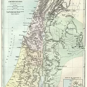
Jigsaw Puzzle : Map of Palestine and the Holy Land


![]()
Jigsaw Puzzles from Mary Evans Picture Library
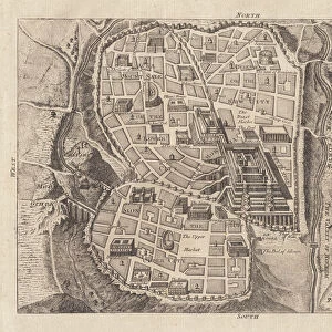
Map of Palestine and the Holy Land
Map of Palestine and the Holy Land - all places named in their Latin form. Date: 1806
Mary Evans Picture Library makes available wonderful images created for people to enjoy over the centuries
Media ID 11575327
© Mary Evans / Grenville Collins Postcard Collection
1806 Chart Damascus Dead Galilee Israel Jerusalem Maps Palestine Palestinian Ports Scale Sidon Syria Syrian Territory Tyre
Jigsaw Puzzle (500 Pieces)
Discover the rich history and intricate geography of the Holy Land with our beautifully detailed Jigsaw Puzzle from Media Storehouse, featuring the "Map of Palestine and the Holy Land" by Rights Managed from Mary Evans Prints Online. Dated back to 1806, this captivating puzzle showcases all the significant places named in their Latin forms, providing an educational and engaging experience for puzzle enthusiasts. Immerse yourself in the history and culture of this ancient land as you piece together this stunning jigsaw puzzle. A perfect addition to any home or classroom, this challenging yet rewarding puzzle is sure to provide hours of enjoyment for puzzle solvers of all ages.
500 piece puzzles are custom made in the UK and hand-finished on 100% recycled 1.5 mm millboard. There is a level of repetition in jigsaw shapes with each matching piece away from its pair. The completed puzzle measures 38x50cm and is delivered packaged in an attractive presentation box specially designed to fit most letter box slots
Jigsaw Puzzles are an ideal gift for any occasion
Estimated Product Size is 38cm x 50.2cm (15" x 19.8")
These are individually made so all sizes are approximate
Artwork printed orientated as per the preview above, with landscape (horizontal) or portrait (vertical) orientation to match the source image.
FEATURES IN THESE COLLECTIONS
> Arts
> Artists
> S
> Syrian Syrian
> Asia
> Israel
> Related Images
> Asia
> Palestine
> Jerusalem
> Asia
> Palestine
> Related Images
> Asia
> Syria
> Related Images
EDITORS COMMENTS
This intricately detailed map, titled "Palestina et Terra Sancta" and dated 1806, offers a glimpse into the historical geography of the Middle East, focusing on the region now known as Palestine and the Holy Land. The map, which is adorned with Latin names for various places, was created during a time when European powers were increasing their influence in the region. The map provides a clear representation of the coastal cities, including Tyre, Sidon, and Jaffa, with their ports marked as important points of entry and exit. The Dead Sea, the lowest point on Earth, is also depicted, along with the Syrian border and the bustling city of Damascus. The heart of the map, however, is the region of Galilee and Judea, which includes the ancient city of Jerusalem. The map's key reveals that the scale is set at 1:1,250,000, providing a sense of the vastness of the land. The map serves as an essential historical document, illustrating the complex geography of the region during a time of significant political and cultural change. It offers a window into the past, providing valuable context for understanding the rich history of the Middle East, particularly the Holy Land, and its enduring significance in world history.
MADE IN THE UK
Safe Shipping with 30 Day Money Back Guarantee
FREE PERSONALISATION*
We are proud to offer a range of customisation features including Personalised Captions, Color Filters and Picture Zoom Tools
SECURE PAYMENTS
We happily accept a wide range of payment options so you can pay for the things you need in the way that is most convenient for you
* Options may vary by product and licensing agreement. Zoomed Pictures can be adjusted in the Basket.