Greetings Card > Arts > Artists > S > Syrian Syrian
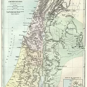
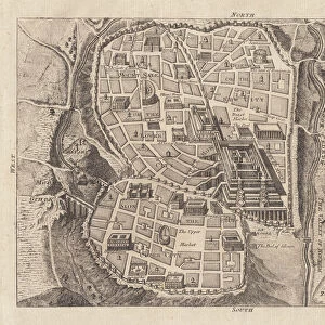
Greetings Card : Map of Palestine and the Holy Land


![]()
Cards from Mary Evans Picture Library
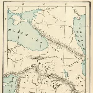
Map of Palestine and the Holy Land
Map of Palestine and the Holy Land - all places named in their Latin form. Date: 1806
Mary Evans Picture Library makes available wonderful images created for people to enjoy over the centuries
Media ID 11575327
© Mary Evans / Grenville Collins Postcard Collection
1806 Chart Damascus Dead Galilee Israel Jerusalem Maps Palestine Palestinian Ports Scale Sidon Syria Syrian Territory Tyre
Greetings Card Large (A4)
Introducing the latest addition to our Greetings Cards collection from Media Storehouse - a beautifully intricate and historically significant design featuring a map of Palestine and the Holy Land. Dating back to 1806, this exquisite image of the region, showcasing all places named in their Latin form, is sourced from the extensive archives of Mary Evans Prints Online. Ideal for those with a deep appreciation for history and culture, this captivating card design is perfect for various occasions, making a thoughtful and unique gift for friends and family. Add a personal touch with a heartfelt message and let the rich history of this map inspire your words.
Create your own large greetings card. Size when folded is A4 (21x30cm or 8.3x11.7 inches)
Greetings Cards suitable for Birthdays, Weddings, Anniversaries, Graduations, Thank You and much more
Estimated Image Size (if not cropped) is 21cm x 26.4cm (8.3" x 10.4")
Estimated Product Size is 42cm x 29.7cm (16.5" x 11.7")
These are individually made so all sizes are approximate
Artwork printed orientated as per the preview above, with portrait (vertical) orientation to match the source image.
FEATURES IN THESE COLLECTIONS
> Arts
> Artists
> S
> Syrian Syrian
> Asia
> Israel
> Related Images
> Asia
> Palestine
> Jerusalem
> Asia
> Palestine
> Related Images
> Asia
> Syria
> Related Images
EDITORS COMMENTS
This intricately detailed map, titled "Palestina et Terra Sancta" and dated 1806, offers a glimpse into the historical geography of the Middle East, focusing on the region now known as Palestine and the Holy Land. The map, which is adorned with Latin names for various places, was created during a time when European powers were increasing their influence in the region. The map provides a clear representation of the coastal cities, including Tyre, Sidon, and Jaffa, with their ports marked as important points of entry and exit. The Dead Sea, the lowest point on Earth, is also depicted, along with the Syrian border and the bustling city of Damascus. The heart of the map, however, is the region of Galilee and Judea, which includes the ancient city of Jerusalem. The map's key reveals that the scale is set at 1:1,250,000, providing a sense of the vastness of the land. The map serves as an essential historical document, illustrating the complex geography of the region during a time of significant political and cultural change. It offers a window into the past, providing valuable context for understanding the rich history of the Middle East, particularly the Holy Land, and its enduring significance in world history.
MADE IN THE UK
Safe Shipping with 30 Day Money Back Guarantee
FREE PERSONALISATION*
We are proud to offer a range of customisation features including Personalised Captions, Color Filters and Picture Zoom Tools
SECURE PAYMENTS
We happily accept a wide range of payment options so you can pay for the things you need in the way that is most convenient for you
* Options may vary by product and licensing agreement. Zoomed Pictures can be adjusted in the Basket.