Home > Africa > Equatorial Guinea > Maps
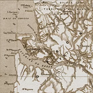
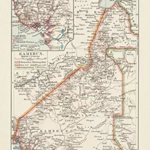
'Cameroun et Fernando Po; L'Ouest Africain, 1914. Creator: Unknown

![]()
Wall Art and Photo Gifts from Heritage Images
'Cameroun et Fernando Po; L'Ouest Africain, 1914. Creator: Unknown
'Cameroun et Fernando Po; L'Ouest Africain, 1914. From "Grande Geographie Bong Illustree", 1914
Heritage Images features heritage image collections
Media ID 36295809
© The Print Collector/Heritage Images
Atlantic Ocean Cameroon Cartography Central Africa Central African Colonies Colony Island Map Making Mapmaking Ocean West Africa West African
FEATURES IN THESE COLLECTIONS
> Africa
> Cameroon
> Related Images
> Africa
> Equatorial Guinea
> Maps
> Africa
> Equatorial Guinea
> Related Images
> Africa
> Guinea
> Related Images
Cameroun et Fernando Po; L'Ouest Africain, 1914
EDITORS COMMENTS
is a captivating black and white print depicting a map of Cameroon and Fernando Po, located on the west coast of Central Africa. The map is taken from the 1914 edition of "Grande Geographie Illustree," a renowned geographical publication of the time. The map illustrates the intricate details of the region, with the Atlantic Ocean to the west, Cameroon to the north, and Equatorial Guinea, specifically Fernando Po, to the south. The map is adorned with various geographical features, including rivers, mountains, and islands. The equator is clearly marked, highlighting the region's proximity to the equatorial line. At the time, Cameroon was under German colonial rule, while Fernando Po was a Spanish colony. The map reflects the colonial division of Africa, with distinct territories allocated to different European powers. The mapmaking process during the colonial era was a significant aspect of the European conquest and domination of Africa. The print offers a glimpse into the cartographic representation of Africa during the early 20th century. The map's intricacy and detail demonstrate the advanced techniques used in mapmaking during this period. The black and white image adds to the historical authenticity of the print, transporting us back to a time when the world was being explored and mapped in unprecedented detail. The "Cameroun et Fernando Po; L'Ouest Africain, 1914" print is an essential historical artifact, providing valuable insights into the geography and colonial history of Central Africa during the 1910s. Its intricate details and historical significance make it a fascinating addition to any collection of maps or African studies.
MADE IN THE UK
Safe Shipping with 30 Day Money Back Guarantee
FREE PERSONALISATION*
We are proud to offer a range of customisation features including Personalised Captions, Color Filters and Picture Zoom Tools
SECURE PAYMENTS
We happily accept a wide range of payment options so you can pay for the things you need in the way that is most convenient for you
* Options may vary by product and licensing agreement. Zoomed Pictures can be adjusted in the Basket.