Greetings Card > Europe > United Kingdom > England > Birmingham > Area > Browns Green
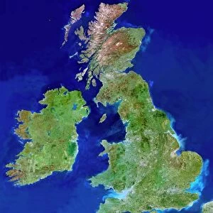
Greetings Card : British Isles, satellite image


![]()
Cards from Science Photo Library
British Isles, satellite image
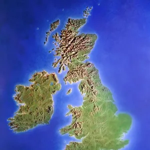
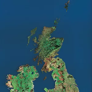
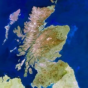
UK and Ireland. Satellite image of the UK and the Republic of Ireland (Eire). North is at top. Water is blue, vegetation is green, dry or barren areas are brown, and snow and ice are white. The Irish Sea lies between the UK mainland (right) and the island of Ireland and Northern Ireland (left). The North Sea is at upper right. The English Channel separates the UK from France (part of which is seen at bottom right). Shallow coastal areas are light blue. Major cities and other urban areas are grey patches. London (lower right), Birmingham (north-west of London), Glasgow (upper centre in Scotland, below the brown Highlands area) and Dublin (east coast of Ireland) are all seen
Science Photo Library features Science and Medical images including photos and illustrations
Media ID 6375983
© PLANETOBSERVER/SCIENCE PHOTO LIBRARY
British Isles Country Earth Observation Earth Science From Space Great Ireland Island Landsat 5 Northern Ireland Satellite Satellite Image Sciences Scot Land Wales
Greetings Card (A5)
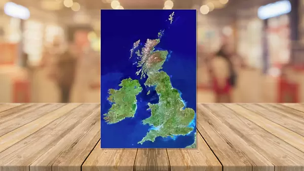
Discover the breathtaking beauty of the British Isles with our selection of greeting cards from Media Storehouse. Featuring an awe-inspiring satellite image of the United Kingdom and the Republic of Ireland by Science Photo Library, these cards showcase the stunning contrasts of our islands - from the deep blue waters surrounding them, to the lush green vegetation, and the brown dry or barren areas. Experience the majesty of nature from a unique perspective, and make your message all the more memorable with these visually striking cards. Perfect for any occasion, these cards are sure to leave a lasting impression.
Create your own greetings card. Size when folded is A5 (14.5x21cm or 5.7x8.3 inches)
Greetings Cards suitable for Birthdays, Weddings, Anniversaries, Graduations, Thank You and much more
Estimated Image Size (if not cropped) is 14.5cm x 21cm (5.7" x 8.3")
Estimated Product Size is 29cm x 21cm (11.4" x 8.3")
These are individually made so all sizes are approximate
Artwork printed orientated as per the preview above, with portrait (vertical) orientation to match the source image.
FEATURES IN THESE COLLECTIONS
> Animals
> Mammals
> Muridae
> Blue-grey Mouse
> Animals
> Mammals
> Muridae
> Water Mouse
> Europe
> France
> Canton
> Landes
> Europe
> Republic of Ireland
> Dublin
> Europe
> Republic of Ireland
> Related Images
> Europe
> United Kingdom
> England
> Birmingham
> Area
> Birmingham City Centre
> Europe
> United Kingdom
> England
> Birmingham
> Area
> Browns Green
> Europe
> United Kingdom
> England
> Birmingham
> Related Images
> Europe
> United Kingdom
> England
> London
> Museums
> British Library
> Europe
> United Kingdom
> England
> London
> Towns
> West Green
EDITORS COMMENTS
This satellite image showcases the stunning beauty of the British Isles, comprising the United Kingdom and Ireland. With its north-oriented perspective, this print offers a bird's-eye view of these enchanting lands. The vibrant blue hues depict the surrounding waters, including the Irish Sea that separates mainland UK from Ireland and Northern Ireland. Towards the upper right corner lies the vast North Sea. The distinct colors on this print provide valuable insights into various terrains: lush green represents abundant vegetation, while brown signifies dry or barren areas. Snow-capped peaks and icy expanses are depicted in pristine white. Notably, shallow coastal regions appear as light blue shades. As we explore this image further, grey patches emerge to represent major cities and urban areas across both countries. London stands out prominently in the lower right corner, with Birmingham positioned northwest of it. In Scotland's upper center lies Glasgow amidst a backdrop of majestic brown Highlands; Dublin graces Ireland's east coast. Captured by Landsat 5 satellite imagery technology, this photograph is not only visually striking but also serves as an invaluable tool for earth scientists studying our planet from space. Science Photo Library has expertly curated this remarkable snapshot of Europe's magnificent British Isles for all to appreciate their natural wonders and human settlements alike.
MADE IN THE UK
Safe Shipping with 30 Day Money Back Guarantee
FREE PERSONALISATION*
We are proud to offer a range of customisation features including Personalised Captions, Color Filters and Picture Zoom Tools
SECURE PAYMENTS
We happily accept a wide range of payment options so you can pay for the things you need in the way that is most convenient for you
* Options may vary by product and licensing agreement. Zoomed Pictures can be adjusted in the Basket.