Glass Frame > Animals > Mammals > Soricidae > Navigator
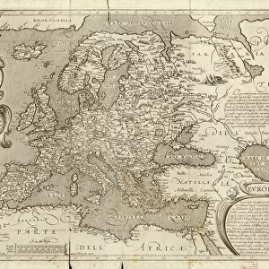
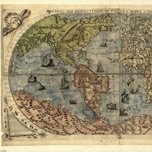
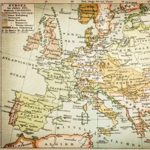
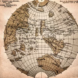
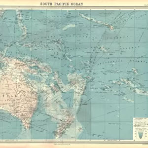
Glass Frame : Historical Map of Dutch Navigators Island of Bali Illustration


![]()
Mounted Prints from Fine Art Storehouse
Historical Map of Dutch Navigators Island of Bali Illustration
Very Rare, Beautifully Illustrated Antique Engraved Victorian Illustration of Historical Map of Dutch Navigators on the Island of Bali. Copyright has expired on this artwork. Digitally restored
Unleash your creativity and transform your space into a visual masterpiece!
bauhaus1000
Media ID 13667025
© bauhaus1000
16th Century 16th Century Style 78273 Bali Chart Commercial Dock Compass Diagram Direction Discovery Dutch Culture European Culture Exploration Explorer Guidance Harbor Image Created 16th Century Indigenous Culture Indonesia Island Journey Navigational Compass Navigational Equipment Pacific Ocean Passenger Craft Passenger Ship Sailing Ship Sea Passage Ship South Pacific Ocean Sumatra Sumatra Indonesia Tropical Climate Indie Indies Victorian Style
7"x5" Glass Mount
Wall mounted or free-standing, these black edged glass frames feature a smooth chamfered edge and a stylish black border (on back face of the glass). Manufactured from 4mm thick glass, Glass Mounts are a durable, professional way of displaying and protecting your prints. Your 7x5 print is slotted into the back of the frame so can easily be changed if needed.
Tempered Glass Mounts are ideal for wall display, plus the smaller sizes can also be used free-standing via an integral stand
Estimated Image Size (if not cropped) is 17.7cm x 12.7cm (7" x 5")
Estimated Product Size is 20.3cm x 16.2cm (8" x 6.4")
These are individually made so all sizes are approximate
Artwork printed orientated as per the preview above, with landscape (horizontal) orientation to match the source image.
FEATURES IN THESE COLLECTIONS
> Fine Art Storehouse
> Map
> Historical Maps
> Animals
> Mammals
> Soricidae
> Navigator
> Arts
> Artists
> O
> Oceanic Oceanic
> Arts
> Street art graffiti
> Digital art
> Digital paintings
> Asia
> Indonesia
> Related Images
> Asia
> Related Images
> Europe
> Related Images
> Maps and Charts
> Early Maps
> Maps and Charts
> Related Images
EDITORS COMMENTS
This beautifully illustrated antique print showcases a rare historical map of Dutch navigators on the island of Bali. Created in the 16th century style, this engraving captures the essence of European culture and exploration during that era. The image depicts a passenger ship sailing through the South Pacific Ocean, symbolizing the adventurous spirit of early explorers. The intricate woodcut illustration provides a glimpse into indigenous cultures and Victorian-style guidance for sea voyages. It serves as a testament to the rich history and discovery associated with Dutch culture in Indonesia's tropical climate. The black and white design emphasizes both the old-world charm and timeless significance of this piece. With Sumatra visible in the background, it highlights how these navigators explored multiple islands within Southeast Asia. Displayed within this image are various elements such as commercial docks, harbors, maps, compasses, charts, nautical vessels, and navigational equipment - all essential tools for successful journeys at sea. Digitally restored to its former glory by bauhaus1000 from Fine Art Storehouse, this print offers viewers an opportunity to appreciate centuries-old craftsmanship while immersing themselves in tales of exploration across distant oceans.
MADE IN THE UK
Safe Shipping with 30 Day Money Back Guarantee
FREE PERSONALISATION*
We are proud to offer a range of customisation features including Personalised Captions, Color Filters and Picture Zoom Tools
SECURE PAYMENTS
We happily accept a wide range of payment options so you can pay for the things you need in the way that is most convenient for you
* Options may vary by product and licensing agreement. Zoomed Pictures can be adjusted in the Basket.