Glass Coaster > Europe > United Kingdom > Scotland > Edinburgh > Edinburgh
Glass Coaster : Map of the Seat of War, 1900. Creator: Unknown


![]()
Home Decor from Heritage Images
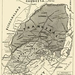
Map of the Seat of War, 1900. Creator: Unknown
Map of the Seat of War, 1900. From " South Africa and the Transvaal War, Vol. II", by Louis Creswicke. [T. C. & E. C. Jack, Edinburgh, 1900]
Heritage Images features heritage image collections
Media ID 19778919
© The Print Collector/Heritage Images
Cape Colony Cartography Creswicke Jack Louis Louis Creswicke Map Making Mapmaking Orange Free State South Africa South Africa And The Transvaal War Tc And Ec Tc And Ec Jack Transvaal
Glass Coaster
Individual Glass Coaster. Stylish and elegant polished safety glass, toughened and heat resistant (10x10cm, 7mm thick). Price shown is per individual coaster.
Individual Glass Coaster. Elegant polished safety toughened glass and heat resistant, matching Place Mats are also available
Estimated Image Size (if not cropped) is 6.1cm x 7.6cm (2.4" x 3")
Estimated Product Size is 10cm x 10cm (3.9" x 3.9")
These are individually made so all sizes are approximate
Artwork printed orientated as per the preview above, with portrait (vertical) orientation to match the source image.
FEATURES IN THESE COLLECTIONS
> Africa
> Related Images
> Africa
> South Africa
> Maps
> Africa
> South Africa
> Related Images
> Arts
> Literature
> Illustration
> Arts
> Literature
> Europe
> United Kingdom
> Scotland
> Edinburgh
> Edinburgh
> Europe
> United Kingdom
> Scotland
> Lothian
> Edinburgh
> Maps and Charts
> Related Images
EDITORS COMMENTS
This print showcases a historical treasure, the "Map of the Seat of War, 1900". Created by an unknown cartographer and featured in Louis Creswicke's book "South Africa and the Transvaal War, Vol. II" this map offers a fascinating glimpse into South Africa's tumultuous past. The intricate details on this map highlight various locations within the continent, including South Africa itself, as well as the Transvaal region and Orange Free State. It serves as both a geographical reference and an illustration of significant events that unfolded during this period. Dating back to the turn of the 20th century, this piece represents not only a valuable artifact but also a testament to the artistry involved in mapmaking during that era. The careful craftsmanship is evident through its precise lines and meticulous labeling. As we explore this image further, it becomes apparent that it is more than just a simple representation of landmasses; it holds stories of conflict and struggle within its borders. This particular map played an essential role in documenting South Africa's history during times of war. Preserved by The Print Collector - renowned for their dedication to preserving historical prints - this photograph allows us to appreciate not only its aesthetic appeal but also its significance as an educational tool for understanding our world's complex past.
MADE IN THE UK
Safe Shipping with 30 Day Money Back Guarantee
FREE PERSONALISATION*
We are proud to offer a range of customisation features including Personalised Captions, Color Filters and Picture Zoom Tools
SECURE PAYMENTS
We happily accept a wide range of payment options so you can pay for the things you need in the way that is most convenient for you
* Options may vary by product and licensing agreement. Zoomed Pictures can be adjusted in the Basket.