Home > Europe > Republic of Ireland > Maps
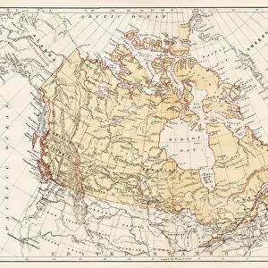
Map of County Kilkenny, Ireland, 1924-1926

![]()
Wall Art and Photo Gifts from Heritage Images
Map of County Kilkenny, Ireland, 1924-1926
Map of County Kilkenny, Ireland, 1924-1926. A print from Hutchinsons Britain Beautiful, edited by Walter Hutchinson, volume III, 1924-1926
Heritage Images features heritage image collections
Media ID 14924071
© The Print Collector / Heritage-Images
Cartography County Ireland Irish Leinster Map Making Kilkenny Print Collector8
EDITORS COMMENTS
This print takes us back in time to the early 20th century, specifically between 1924 and 1926. It showcases a meticulously detailed map of County Kilkenny, Ireland, which was featured in Hutchinsons Britain Beautiful, edited by Walter Hutchinson. The monochrome aesthetic adds an air of nostalgia to this piece of cartography. Every contour line and intricate detail is beautifully captured, allowing us to appreciate the artistry involved in map making during that era. The print provides a glimpse into the geography and location of County Kilkenny within the larger context of Ireland. As we explore this vintage map, we are transported to Leinster province where Kilkenny proudly stands. Its borders are clearly defined as it nestles amidst lush green landscapes and rolling hills. This snapshot from history offers a unique perspective on how our understanding of countries and regions has evolved over time. Although the creator remains unknown, their work has been preserved by The Print Collector - an organization dedicated to safeguarding historical prints for future generations. With no commercial use mentioned here, we can simply marvel at this remarkable piece as a testament to both Irish heritage and the artistry behind map making in the early 20th century.
MADE IN THE UK
Safe Shipping with 30 Day Money Back Guarantee
FREE PERSONALISATION*
We are proud to offer a range of customisation features including Personalised Captions, Color Filters and Picture Zoom Tools
FREE COLORIZATION SERVICE
You can choose advanced AI Colorization for this picture at no extra charge!
SECURE PAYMENTS
We happily accept a wide range of payment options so you can pay for the things you need in the way that is most convenient for you
* Options may vary by product and licensing agreement. Zoomed Pictures can be adjusted in the Basket.