Framed Print > Europe > United Kingdom > Wales > Maps
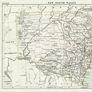
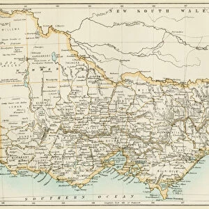
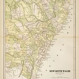
Framed Print : New South Wales map, 1800s


![]()
Framed Photos from North Wind
New South Wales map, 1800s
Map of New South Wales, Australia, 1870s.
Color lithograph reproduction of a 19th-century illustration
North Wind Picture Archives brings history to life with stock images and hand-colored illustrations
Media ID 5882613
© North Wind Picture Archives
Australia Australian British Empire
14"x12" (38x32cm) Modern Frame
Step back in time with our exquisite Framed Prints from Media Storehouse, featuring a captivating image of a 1870s map of New South Wales, Australia. Meticulously reproduced from a color lithograph illustration of the 19th century, this vintage map showcases intricate details of the region's geography during an era of exploration and discovery. Each print is beautifully framed, adding a touch of history and character to your home or office decor. Bring a piece of the past into your present with our authentic and captivating Framed Prints.
Wood effect frame, card mounted, 10x8 archival quality photo print. Overall outside dimensions 14x12 inches (38x32cm). Environmentally and ozone friendly, 40mm wide x 15mm Polycore® moulding has the look of real wood, is durable and light and easy to hang. Biodegradable and made with non-chlorinated gases (no toxic fumes) it is efficient; producing 100 tons of polystyrene can save 300 tons of trees! Prints are glazed with lightweight, shatterproof, optical clarity acrylic (providing the same general protection from the environment as glass). The back is stapled hardboard with a sawtooth hanger attached. Note: To minimise original artwork cropping, for optimum layout, and to ensure print is secure, the visible print may be marginally smaller
Contemporary Framed and Mounted Prints - Professionally Made and Ready to Hang
Estimated Image Size (if not cropped) is 24.4cm x 17.4cm (9.6" x 6.9")
Estimated Product Size is 37.6cm x 32.5cm (14.8" x 12.8")
These are individually made so all sizes are approximate
Artwork printed orientated as per the preview above, with landscape (horizontal) orientation to match the source image.
FEATURES IN THESE COLLECTIONS
> Europe
> United Kingdom
> Wales
> Maps
> Europe
> United Kingdom
> Wales
> Posters
> Europe
> United Kingdom
> Wales
> Related Images
> Maps and Charts
> British Empire Maps
> Maps and Charts
> Related Images
> Maps and Charts
> Wales
> Oceania
> Australia
> Related Images
> North Wind Picture Archives
> Maps
EDITORS COMMENTS
This print transports us back to the 1800s, offering a glimpse into the rich history of New South Wales, Australia. The map depicted here is a color lithograph reproduction of an original 19th-century illustration, showcasing the intricate details and artistry that were prevalent during this era. As we gaze at this vintage piece, we are reminded of the deep heritage and traditional roots that shaped New South Wales. The map serves as a testament to the region's historical significance within the British Empire during the 1800s. It not only highlights geographical features but also provides insight into how society was structured at that time. The muted colors and delicate lines evoke a sense of nostalgia, transporting us to an era long gone by. This artwork allows us to appreciate both its aesthetic value and its historical importance in understanding how New South Wales has evolved over time. Whether you are an art enthusiast or a history buff, this print offers a unique opportunity to own a piece of Australian history. Display it proudly on your wall or use it as educational material for students eager to learn about their country's past
MADE IN THE UK
Safe Shipping with 30 Day Money Back Guarantee
FREE PERSONALISATION*
We are proud to offer a range of customisation features including Personalised Captions, Color Filters and Picture Zoom Tools
SECURE PAYMENTS
We happily accept a wide range of payment options so you can pay for the things you need in the way that is most convenient for you
* Options may vary by product and licensing agreement. Zoomed Pictures can be adjusted in the Basket.