Framed Print > Animals > Mammals > Soricidae > Navigator
Framed Print : Map of Magellans round the world voyage, 1519-1521


![]()
Framed Photos from Heritage Images
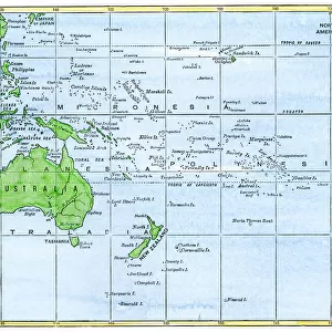
Map of Magellans round the world voyage, 1519-1521
Map of Magellans round the world voyage, 1519-1521. A Portuguese-born navigator sponsored by Spain, Ferdinand Magellan (c1480-1521) led the expedition that made the first circumnavigation of the globe. This Mercator projection map shows the route taken, which included the first passage through the straits at the southern tip of South America that bear Magellans name. Magellan did not himself complete the voyage, as he was killed in the Philippines in a clash with natives. Of the five ships that set out from Spain in 1519, only one, the Victoria, commanded by Juan de Elcano, returned safely. From the Bibliotheque Nationale, Paris
Heritage Images features heritage image collections
Media ID 14847398
© Ann Ronan Picture Library / Heritage-Images
Accomplishment Achievement Cartography Chart Circumnavigation Discovery Exploration Ferdinand Magellan Fernando Journey Magellan Map Making Navigation Pioneer Route Straits Of Magellan Success Voyage World Ann Ronan Pictures Fernao Magalhaes Mercator Projection
22"x18" (58x48cm) Modern Frame
Discover history with our stunning Framed Print of Magellan's Map of the World from the Year 1519-1521. This exquisite piece, featuring the iconic map created by an unknown artist during Magellan's groundbreaking circumnavigation voyage, is a testament to the rich maritime history of the 16th century. Bring this captivating work of art into your home or office and transport yourself back in time. Meticulously crafted and printed on high-quality archival paper, this Framed Print is a must-have for history enthusiasts and world travelers alike. Authentically mounted and framed with care, it is sure to impress and inspire.
Wood effect frame, card mounted, 16x12 archival quality photo print. Overall outside dimensions 22x18 inches (58x48cm). Environmentally and ozone friendly, 40mm wide x 15mm Polycore® moulding has the look of real wood, is durable and light and easy to hang. Biodegradable and made with non-chlorinated gases (no toxic fumes) it is efficient; producing 100 tons of polystyrene can save 300 tons of trees! Prints are glazed with lightweight, shatterproof, optical clarity acrylic (providing the same general protection from the environment as glass). The back is stapled hardboard with a sawtooth hanger attached. Note: To minimise original artwork cropping, for optimum layout, and to ensure print is secure, the visible print may be marginally smaller
Contemporary Framed and Mounted Prints - Professionally Made and Ready to Hang
Estimated Image Size (if not cropped) is 39.6cm x 27.1cm (15.6" x 10.7")
Estimated Product Size is 57.9cm x 47.8cm (22.8" x 18.8")
These are individually made so all sizes are approximate
Artwork printed orientated as per the preview above, with landscape (horizontal) orientation to match the source image.
FEATURES IN THESE COLLECTIONS
> Animals
> Mammals
> Soricidae
> Navigator
> Asia
> Philippines
> Maps
> Asia
> Philippines
> Related Images
> Europe
> France
> Paris
> Maps
> Europe
> Portugal
> Related Images
> Europe
> Spain
> Related Images
> Heritage Images
> Maps Charts & Plans
EDITORS COMMENTS
This print showcases a historic map of Ferdinand Magellan's groundbreaking voyage around the world from 1519 to 1521. As a Portuguese-born navigator sponsored by Spain, Magellan led an expedition that achieved the remarkable feat of circumnavigating the globe for the first time in history. The Mercator projection map vividly depicts the route taken by Magellan and his crew, highlighting their monumental achievement of being the first to navigate through the straits at the southern tip of South America, now known as Magellan's Straits. Tragically, Magellan himself did not witness the completion of this momentous journey as he lost his life during a clash with natives in the Philippines. Despite this setback, one ship out of five that departed from Spain in 1519 managed to return safely. Commanded by Juan de Elcano, the Victoria became a symbol of triumph and resilience. This beautifully detailed print is sourced from Bibliotheque Nationale in Paris and provides an intriguing glimpse into early cartography and exploration. It serves as a testament to human curiosity and determination to conquer new frontiers during this era of discovery. The vibrant colors on this sixteenth-century map capture both our fascination with geography and our admiration for those pioneers who dared to venture into uncharted territories.
MADE IN THE UK
Safe Shipping with 30 Day Money Back Guarantee
FREE PERSONALISATION*
We are proud to offer a range of customisation features including Personalised Captions, Color Filters and Picture Zoom Tools
SECURE PAYMENTS
We happily accept a wide range of payment options so you can pay for the things you need in the way that is most convenient for you
* Options may vary by product and licensing agreement. Zoomed Pictures can be adjusted in the Basket.