Framed Print > North America > United States of America > New York > New York > Maps
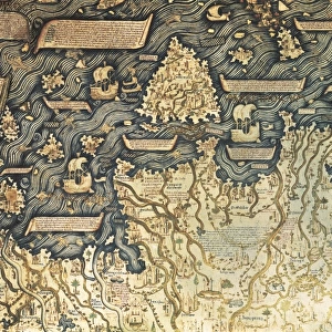
Framed Print : Map of the world 1869


![]()
Framed Photos from Fine Art Storehouse
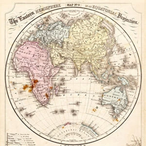
Map of the world 1869
Cornells Grammars-School Geography - S.S. Cornell - New York D. Appleton and Company 1869
Unleash your creativity and transform your space into a visual masterpiece!
THEPALMER
Media ID 13668825
© Roberto A Sanchez
62990 Antarctica Arctic Atlas Earth Globe Navigational Equipment Hemisphere North Pole Oceania Paper South Pole World Map Mappa Mundi Retro Styled
14"x12" (38x32cm) Modern Frame
Discover the captivating history of cartography with our exquisite "Map of the World 1869" Framed Print from ThePalmer at Media Storehouse. This stunning piece, hailing from the esteemed Cornell's Grammars-School Geography published by D. Appleton and Company in New York, takes you on a journey back in time. The intricate details of this antique map showcase the world as it was known over a century ago. The rich history and academic charm of this vintage map is beautifully preserved in our high-quality framed print. Elevate your home or office décor with this unique and educational addition.
Wood effect frame, card mounted, 10x8 archival quality photo print. Overall outside dimensions 14x12 inches (38x32cm). Environmentally and ozone friendly, 40mm wide x 15mm Polycore® moulding has the look of real wood, is durable and light and easy to hang. Biodegradable and made with non-chlorinated gases (no toxic fumes) it is efficient; producing 100 tons of polystyrene can save 300 tons of trees! Prints are glazed with lightweight, shatterproof, optical clarity acrylic (providing the same general protection from the environment as glass). The back is stapled hardboard with a sawtooth hanger attached. Note: To minimise original artwork cropping, for optimum layout, and to ensure print is secure, the visible print may be marginally smaller
Contemporary Framed and Mounted Prints - Professionally Made and Ready to Hang
Estimated Image Size (if not cropped) is 24.4cm x 17.4cm (9.6" x 6.9")
Estimated Product Size is 37.6cm x 32.5cm (14.8" x 12.8")
These are individually made so all sizes are approximate
Artwork printed orientated as per the preview above, with landscape (horizontal) orientation to match the source image.
FEATURES IN THESE COLLECTIONS
> Fine Art Storehouse
> The Magical World of Illustration
> Palmer Illustrated Collection
> Fine Art Storehouse
> Map
> Historical Maps
> Maps and Charts
> Related Images
> Maps and Charts
> World
> North America
> United States of America
> New York
> New York
> Maps
> North America
> United States of America
> New York
> Related Images
EDITORS COMMENTS
This print showcases a vintage treasure, the "Map of the World 1869". A true testament to cartography's artistry and historical significance, this retro-styled piece takes us on a journey through time. The map originates from "Cornells Grammars-School Geography" published by S. S. Cornell in New York back in 1869. Engraved with meticulous detail, this antique image captures our planet's diverse landscapes and vast oceans. From the Arctic to Antarctica, every corner of Earth is beautifully depicted on this engraved illustration. The map offers a glimpse into physical geography as it was understood over a century ago. With its horizontal orientation and old-world charm, this mappa mundi transports us back to an era when globe navigational equipment reigned supreme. Its paper texture adds an authentic touch that complements any space seeking nostalgic vibes or intellectual curiosity. As we explore the continents and seas on this mesmerizing artwork, we are reminded of how much our world has evolved since 1869. It serves as a reminder of both our shared history and the ever-changing nature of our planet. "The Map of the World 1869" by THEPALMER is more than just an exquisite piece; it encapsulates centuries' worth of knowledge and exploration within its borders. Whether you're an avid collector or simply appreciate fine art with educational value, this print will undoubtedly become a cherished addition to your collection
MADE IN THE UK
Safe Shipping with 30 Day Money Back Guarantee
FREE PERSONALISATION*
We are proud to offer a range of customisation features including Personalised Captions, Color Filters and Picture Zoom Tools
SECURE PAYMENTS
We happily accept a wide range of payment options so you can pay for the things you need in the way that is most convenient for you
* Options may vary by product and licensing agreement. Zoomed Pictures can be adjusted in the Basket.