Home > Europe > United Kingdom > England > Plymouth
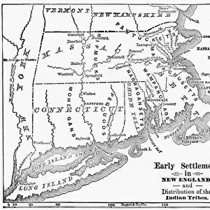
Vintage Map of New England

![]()
Wall Art and Photo Gifts from Fine Art Storehouse
Vintage Map of New England
Vintage Map of New England at the beginning of the 18th century
Unleash your creativity and transform your space into a visual masterpiece!
duncan1890
Media ID 13666421
© Duncan Walker
18th Century 18th Century Style American Culture Boston Boston Massachusetts Cape Cod Chart Colony Connecticut Eastern Usa Ephemera Geographical Locations Image Created 18th Century Maine Massachusetts Navigational Equipment New England New England Usa New Hampshire North America Past Plymouth Printed Media Rhode Island Styles The Americas Traditional Culture Vermont
FEATURES IN THESE COLLECTIONS
> Europe
> France
> Canton
> Maine
> Europe
> United Kingdom
> England
> Hampshire
> Related Images
> Europe
> United Kingdom
> England
> Maps
> Europe
> United Kingdom
> England
> Paintings
> Europe
> United Kingdom
> England
> Plymouth
> Fine Art Storehouse
> Map
> Historical Maps
> Fine Art Storehouse
> Map
> USA Maps
> Maps and Charts
> Early Maps
> North America
> United States of America
> Connecticut
> Related Images
> North America
> United States of America
> Maine
> Related Images
> North America
> United States of America
> Maps
EDITORS COMMENTS
This vintage map of New England takes us back to the early 18th century, offering a glimpse into the rich history and cultural heritage of this region. The intricate details and artistry showcased in this woodcut print transport us to a time when cartography was both a science and an art form. The map highlights various geographical locations, from bustling cities like Boston and Plymouth Massachusetts to picturesque coastal areas such as Cape Cod. Navigational equipment is depicted alongside engraved images, providing insight into the tools used by explorers during that era. As we explore this piece further, we are reminded of the significance of New England in shaping American culture. Each colony is meticulously outlined, showcasing their individuality while also emphasizing their collective identity as part of the United States. Printed media from centuries ago often serves as ephemera that captures moments frozen in time. This illustration created in the 18th century not only offers historical value but also showcases traditional culture through its unique style. Duncan1890's photography skills have allowed us to appreciate this old chart with its vertical composition, making it suitable for display on any wall or surface. Although devoid of people, this image speaks volumes about our past and invites viewers to delve deeper into New England's fascinating story.
MADE IN THE UK
Safe Shipping with 30 Day Money Back Guarantee
FREE PERSONALISATION*
We are proud to offer a range of customisation features including Personalised Captions, Color Filters and Picture Zoom Tools
SECURE PAYMENTS
We happily accept a wide range of payment options so you can pay for the things you need in the way that is most convenient for you
* Options may vary by product and licensing agreement. Zoomed Pictures can be adjusted in the Basket.