Fraud Blocker Skip to main content

Home > Europe > United Kingdom > Scotland > Maps

Map of the Clans and Tartans of Scotland

Map of the Clans and Tartans of Scotland
Sold 12
In Stock
We accept all major payment options so you can pay for the things you need in the way that is most convenient for you

MapSeeker Photo Prints and Wall Art

Map of the Clans and Tartans of Scotland

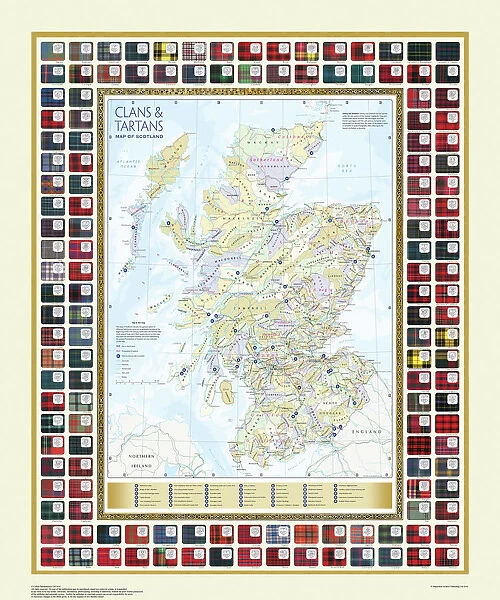
This map of Scotland indicates the general sphere of influence held by the clans and considerable families at the beginning of the 17th century. Some clans and families held small areas of land, and if their names are not on this map, they were not necessarily landless. The areas representing the ancient Principalities of Scotland are indicated on the map. Scotland has a rich and enduring culture steeped in history. One of the most distinctive features, of which are probably that of clanship and the predominantly Highland clans. Highland dress and the tartan is a powerful symbol of the wearerAEs pride in a Scottish ancestry and in Scotland itself. There are few, if any, other forms of national dress which can claim to make such a clear and unequivocal statement, and to be so instantly and widely recognisable. Welcome to the Mapseeker Image library and enter an historic gateway to one of the largest on-line collections of Historic Maps, Nostalgic Views, Vista's and Panorama's from a World gone by.

Media ID 20348040

FEATURES IN THESE COLLECTIONS

> Europe > France > Canton > Landes

> Europe > United Kingdom > Scotland > Maps

> Maps and Charts > Early Maps

> Maps and Charts > Scotland

> MapSeeker > Maps from the British Isles > Scotland and Counties PORTFOLIO

SECURE PAYMENTS
We accept all major payment options so you can pay for the things you need in the way that is most convenient for you

Made in UK
Safe Shipping, Easy Returns

FREE PERSONALISATION
We are proud to offer a range of customisation including Cropping, Captions, and Filters. Zoom Cropping can be adjusted in the basket


EDITORS COMMENTS

This print showcases the "Map of the Clans and Tartans of Scotland" offering a glimpse into the intricate web of influence held by clans and notable families during the early 17th century. While some clans and families may not be featured on this map, it does not imply their landlessness, as they might have possessed smaller territories. The map also highlights the ancient Principalities of Scotland, providing insight into the historical divisions within this culturally rich nation. Scotland's enduring heritage is deeply rooted in its unique features such as clanship and predominantly Highland clans. Among these distinct characteristics, Highland dress and tartan stand out as powerful symbols representing pride in Scottish ancestry and love for their homeland. With its unmistakable design, tartan has become an iconic representation of Scottish identity. Few other national dresses can rival its ability to make such a clear statement or enjoy such widespread recognition across borders. This print serves as a reminder of Scotland's profound history while celebrating its cultural traditions that continue to resonate with people around the world.


Framed Prints

Introducing the striking and historically significant Framed Prints from Media Storehouse's MapSeeker collection. This exquisite piece showcases an intricately detailed Map of the Clans and Tartans of Scotland, dating back to the beginning of the 17th century. Each clan's sphere of influence is vividly depicted, offering a captivating glimpse into Scotland's rich and complex past. Perfectly balanced between history and art, this beautifully framed print adds an authentic touch of Scottish heritage to any room. Bring a piece of Scotland's storied past into your home and embark on a journey of discovery with every glance.


Photo Prints

Introducing the stunning "Map of the Clans and Tartans of Scotland" print from our Media Storehouse collection, brought to you in collaboration with MapSeeker. This exquisite piece of historical artistry transports you back to the early 17th century, offering a captivating glimpse into Scotland's rich tapestry of clans and influential families. With intricate detail and vibrant colors, this map beautifully illustrates the spheres of influence held by various Scottish clans, providing a unique and educational insight into the country's past. Whether you're an avid history enthusiast, a proud Scot, or simply appreciate the beauty of historical cartography, this print is a must-have addition to your home or office. The "Map of the Clans and Tartans of Scotland" print is meticulously reproduced to ensure the highest possible quality, capturing every detail of the original map. Display it proudly on your wall and let the history and heritage of Scotland come alive in your space. Order yours today and join the Media Storehouse family, as we continue to celebrate and share the world's most captivating stories through our extensive range of premium prints.


Poster Prints

Introducing the captivating and historically rich Media Storehouse range of Poster Prints, featuring the intricately detailed "Map of the Clans and Tartans of Scotland" from MapSeeker. This exquisite map transports you back to the early 17th century, offering a fascinating glimpse into the spheres of influence held by the prominent Scottish clans and families. Each element of this beautifully crafted poster is meticulously rendered, inviting you to explore the rich tapestry of Scotland's past. Add a touch of history and culture to your home or office with this magnificent poster print.


Jigsaw Puzzles

Discover the rich history and culture of Scotland with the Media Storehouse range of Jigsaw Puzzles featuring the intricately detailed "Map of the Clans and Tartans of Scotland" from MapSeeker. This captivating puzzle showcases the general sphere of influence held by the clans and significant families at the beginning of the 17th century. Immerse yourself in the intricate patterns and designs of Scottish tartans as you piece together this beautiful and educational puzzle. A perfect activity for history enthusiasts and puzzle lovers alike, this challenging yet rewarding puzzle is a must-have for any home or office. Bring a piece of Scottish heritage into your life with the Media Storehouse Map of the Clans and Tartans of Scotland Jigsaw Puzzle.

diamond
Made With High Grade Materials
thumb_up
Professional Quality Finish
package_2
Carefully Packed To Aid Safe Arrival

You May Also Like


The Historic Map of Scotland "Scotland of Old"The Historic Map of Scotland "Scotland of Old"
Add to Basket
Pictorial Story Map of ScotlandPictorial Story Map of Scotland
Add to Basket
Pictorial History Map of Scotland 1963Pictorial History Map of Scotland 1963
Add to Basket
Pictorial History Map of Wales and Monmouth 1966Pictorial History Map of Wales and Monmouth 1966
Add to Basket
Pictorial History Map of Ireland 1963Pictorial History Map of Ireland 1963
Add to Basket
Old Map of Wolverhampton 1750 by Isaac TaylorOld Map of Wolverhampton 1750 by Isaac Taylor
Add to Basket
Old Map of Sutton Park near Sutton Coldfield 1885Old Map of Sutton Park near Sutton Coldfield 1885
Add to Basket
Old Map of Bath 1851 by John TallisOld Map of Bath 1851 by John Tallis
Add to Basket
Pictorial History Railway Map of BritainPictorial History Railway Map of Britain
Add to Basket
Old Map of The Isle of Wight 1836 by Thomas MouleOld Map of The Isle of Wight 1836 by Thomas Moule
Add to Basket
British Isles Counties, Districts and Unitary Authorities MapBritish Isles Counties, Districts and Unitary Authorities Map
Add to Basket
Old County Map of Sutherland Scotland 1847 by A&C BlackOld County Map of Sutherland Scotland 1847 by A&C Black
Add to Basket

Gallery Wall Inspiration

Scotland 1851
The Historic Map of Scotland "Scotland of Old"
Old Map of the Isle of Islay Scotland 1654 by Johan Blaeu from the Atlas Novus
Old Map of the Isle of Mull Scotland 1654 by Johan Blaue from the Atlas Novus
Map of the Clans and Tartans of Scotland
Pictorial Story Map of Scotland
Pictorial History Map of Scotland 1963
Old County Map of Wigtown Scotland 1847 by A&C Black
Old Map of Scotland 1611 by John Speed
Old Map of Scotland 1852 by Henry George Collins
Old Map of the Isles of Shetland and Orkney 1654 from the Atlas Novus
Old County Map of Fife 1654 by Johan Blaeu from the Atlas Novus
Old County Map of Kyle and Mid Ayrshire 1654 by johan Blaeu from the Atlas Novus
Old County Map of Dunbartonshire, formally called Dumbartonshire, Scotland 1847 by A&C Black
Old Map of the County of Sutherland from the Philips Handy Atlas of 1882
Early Coastal Survey Map of The West Coast of Scotland 1796
Old County Map of Sutherland Scotland 1847 by A&C Black
Old County Map of Renfrew Scotland 1847 by A&C Black
Old County Map of Moray and Nairn Scotland 1847 by A&C Black
Old Map of the Counties of Ross and Cromarty from the Philips Handy Atlas of 1882
Old Map of the Counties of Stirling and Clackmannan from the Philips Handy Atlas of 1882
Old County Map of Renfrewshire Scotland 1654 by Johan Blaue from the Atlas Novus
Old Map of Scotland 1635 by Willem & Johan Blaeu from the Theatrum Orbis Terrarum
Old Map of Galloway Scotland 1654 by Johan Blaeu from the Atlas Novus
Old County Map of Dumfries Scotland 1847 by A&C Black
Old County Map of Aberdeen and Banff Scotland 1847 by A&C Black
Old County Map of Caithness Scotland 1847 by A&C Black

Discover Our Collections


Early MapsEarly Maps
View Collection
LandesLandes
View Collection
Scotland and Counties PORTFOLIOScotland and Counties PORTFOLIO
View Collection
ScotlandScotland
View Collection
MapsMaps
View Collection


© Copyright Media Storehouse, All Rights Reserved 2003 - 2024
Facebook     Pinterest     100% Payment Secure     Reviews IO