Fine Art Print > Europe > United Kingdom > England > London > Towns > Wood Green
Fine Art Print : London, UK, satellite image


![]()
Fine Art Prints from Science Photo Library
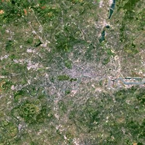
London, UK, satellite image
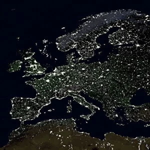
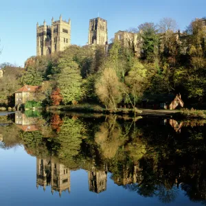
London, UK. Satellite image of the city of London (centre) and its surrounding area. North is at top. The River Thames is seen running through the city from left to right. Forested areas are dark green, agricultural fields are lighter shades of green and brown, urban areas are grey, and water is black. Image created using NaturalVue data obtained from the Landsat 7 satellite
Science Photo Library features Science and Medical images including photos and illustrations
Media ID 1704991
© EARTH SATELLITE CORPORATION/SCIENCE PHOTO LIBRARY
Capital City Earth Observation Farm Land Field Fields Forest Forests From Space Greater London Landsat 7 Nasa Natural Colour Naturalvue River River Thames Satellite Satellite Image Urban Urbanisation Urbanization Vegetation Wood Land
A2 (42x59cm) Fine Art Print
Discover the breathtaking beauty of London from a unique perspective with our Fine Art Print from Media Storehouse, featuring a stunning satellite image of the city by Science Photo Library. Witness the iconic River Thames winding through the heart of London, with the city's famous landmarks such as the Tower of London, the Shard, and the Houses of Parliament, all in perfect alignment. This exquisite print is a must-have for anyone who loves London or appreciates the wonders of modern technology and urban planning. Bring a piece of the city's rich history and vibrant energy into your home or office.
Our Fine Art Prints are printed on 100% acid free, PH neutral paper with archival properties. This printing method is used by museums and art collections to exhibit photographs and art reproductions. Hahnemühle certified studio for digital fine art printing. Printed on 308gsm Photo Rag Paper.
Our fine art prints are high-quality prints made using a paper called Photo Rag. This 100% cotton rag fibre paper is known for its exceptional image sharpness, rich colors, and high level of detail, making it a popular choice for professional photographers and artists. Photo rag paper is our clear recommendation for a fine art paper print. If you can afford to spend more on a higher quality paper, then Photo Rag is our clear recommendation for a fine art paper print.
Estimated Image Size (if not cropped) is 42cm x 42cm (16.5" x 16.5")
Estimated Product Size is 42cm x 59.4cm (16.5" x 23.4")
These are individually made so all sizes are approximate
Artwork printed orientated as per the preview above, with landscape (horizontal) or portrait (vertical) orientation to match the source image.
FEATURES IN THESE COLLECTIONS
> Animals
> Mammals
> Muridae
> Water Mouse
> Arts
> Landscape paintings
> Forest and woodland scenes
> Forest artwork
> Arts
> Landscape paintings
> Waterfall and river artworks
> River artworks
> Europe
> France
> Canton
> Landes
> Europe
> United Kingdom
> England
> Greater London
> Related Images
> Europe
> United Kingdom
> England
> Greater London
> Wood Green
> Europe
> United Kingdom
> England
> London
> Museums
> British Library
> Europe
> United Kingdom
> England
> London
> River Thames
> Europe
> United Kingdom
> England
> London
> Towns
> Wood Green
> Europe
> United Kingdom
> England
> Rivers
> Science Photo Library
> Aerial and Satellite
EDITORS COMMENTS
This print showcases a satellite image of the vibrant city of London, UK. The image captures the heart of the city, with its iconic River Thames flowing gracefully from left to right. As we explore this aerial view, we can distinguish various features that define London's diverse landscape. The dark green patches represent lush forests, while lighter shades of green and brown indicate agricultural fields dotting the outskirts. Urban areas are depicted in shades of grey, symbolizing the bustling metropolis that is London. The black hue represents water bodies scattered throughout the region. Created using NaturalVue data obtained from NASA's Landsat 7 satellite, this remarkable image offers an extraordinary perspective on England's capital city. It allows us to appreciate both its natural beauty and impressive urbanization. From space, one can truly grasp Greater London's vastness and understand how it seamlessly blends nature with human habitation. This photograph not only highlights geographical elements but also emphasizes the importance of preserving these delicate ecosystems amidst rapid urban development. Courtesy of Science Photo Library, this stunning satellite image serves as a testament to our ability to observe Earth from above and gain valuable insights into our planet's ever-changing landscapes.
MADE IN THE UK
Safe Shipping with 30 Day Money Back Guarantee
FREE PERSONALISATION*
We are proud to offer a range of customisation features including Personalised Captions, Color Filters and Picture Zoom Tools
SECURE PAYMENTS
We happily accept a wide range of payment options so you can pay for the things you need in the way that is most convenient for you
* Options may vary by product and licensing agreement. Zoomed Pictures can be adjusted in the Basket.