Fine Art Print > Europe > United Kingdom > England > London > Museums > British Library
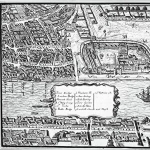
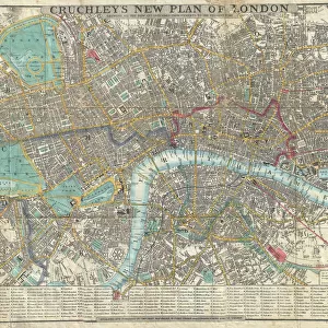
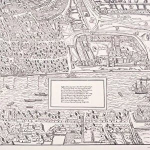
Fine Art Print : Map of the City of London by John Ogilby 1676. Ogilby (also Ogelby


![]()
Fine Art Prints from Mary Evans Picture Library
Map of the City of London by John Ogilby 1676. Ogilby (also Ogelby
Map of the City of London by John Ogilby 1676. Ogilby (also Ogelby, Oglivie - 16001676) was a Scottish translator, impresario and cartographer. Best known for publishing the first British road atlas, he was also a successful translator, noted for publishing his work in handsome illustrated editions. Date: 1676
Mary Evans Picture Library makes available wonderful images created for people to enjoy over the centuries
Media ID 20029070
© Mary Evans Picture Library
1670s 1676 Atlas Capital Cartographer Cartography Draughtsman Impresario Plan Translator Mapmaker Ogilby
A2 (42x59cm) Fine Art Print
Discover the rich history of London through the intricately detailed Map of the City of London by John Ogilby, dating back to 1676. This exquisite fine art print showcases Ogilby's exceptional cartography skills, capturing the essence of the city during the Restoration period. With meticulous attention to detail, Ogilby's map highlights the city's historic landmarks, streets, and waterways. Bring a piece of London's past into your home or office with this stunning, museum-quality fine art print from Media Storehouse's extensive collection.
Our Fine Art Prints are printed on 100% acid free, PH neutral paper with archival properties. This printing method is used by museums and art collections to exhibit photographs and art reproductions. Hahnemühle certified studio for digital fine art printing. Printed on 308gsm Photo Rag Paper.
Our fine art prints are high-quality prints made using a paper called Photo Rag. This 100% cotton rag fibre paper is known for its exceptional image sharpness, rich colors, and high level of detail, making it a popular choice for professional photographers and artists. Photo rag paper is our clear recommendation for a fine art paper print. If you can afford to spend more on a higher quality paper, then Photo Rag is our clear recommendation for a fine art paper print.
Estimated Image Size (if not cropped) is 59.4cm x 37.2cm (23.4" x 14.6")
Estimated Product Size is 59.4cm x 42cm (23.4" x 16.5")
These are individually made so all sizes are approximate
Artwork printed orientated as per the preview above, with landscape (horizontal) orientation to match the source image.
FEATURES IN THESE COLLECTIONS
> Arts
> Artists
> O
> John Ogilby
> Arts
> Landscape paintings
> Waterfall and river artworks
> River artworks
> Europe
> United Kingdom
> England
> London
> Boroughs
> City of London
> Europe
> United Kingdom
> England
> London
> Museums
> British Library
> Europe
> United Kingdom
> England
> London
> River Thames
> Europe
> United Kingdom
> Scotland
> Maps
> Europe
> United Kingdom
> Scotland
> Posters
> Europe
> United Kingdom
> Scotland
> Related Images
> Europe
> United Kingdom
> Scotland
> Rivers
> Maps and Charts
> Related Images
EDITORS COMMENTS
This stunning map print, titled "Map of the City of London and the Boroughs of Southwark and Bermondsey," is a testament to the cartographic prowess of John Ogilby (1600-1676), a Scottish polymath who made significant contributions to the fields of cartography, translating, and impresarial activities during the 17th century. Ogilby, also known by the variant spellings Ogelby and Oglivie, is best remembered for publishing the first British road atlas in 1675. However, this map of London, created in 1676, showcases his exceptional skill as a mapmaker and draughtsman. The intricate detailing of the map is evident in the depiction of the city's streets, buildings, and topography, as well as the winding Thames River and its surrounding docks. The map also highlights the Boroughs of Southwark and Bermondsey, which were important commercial and industrial areas during the 17th century. Ogilby's meticulous attention to detail is further demonstrated by the inclusion of various points of interest, such as churches, schools, and markets. This map is a captivating representation of London during the 1670s and offers a unique glimpse into the city's history. The richly detailed illustrations and elegant design make this a valuable addition to any collection of historical maps or London memorabilia.
MADE IN THE UK
Safe Shipping with 30 Day Money Back Guarantee
FREE PERSONALISATION*
We are proud to offer a range of customisation features including Personalised Captions, Color Filters and Picture Zoom Tools
SECURE PAYMENTS
We happily accept a wide range of payment options so you can pay for the things you need in the way that is most convenient for you
* Options may vary by product and licensing agreement. Zoomed Pictures can be adjusted in the Basket.