Home > Europe > United Kingdom > England > London > Towns > Paddington
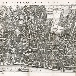
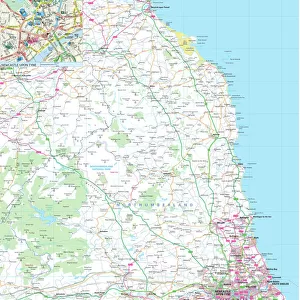
London Map 1806

![]()
Wall Art and Photo Gifts from Mary Evans Picture Library
London Map 1806
London extending from the head of the Paddington Canal West, and to the West India Docks East. Date: 1806
Mary Evans Picture Library makes available wonderful images created for people to enjoy over the centuries
Media ID 14350896
© Mary Evans Picture Library
1806 Churches Maps Plan Squares
FEATURES IN THESE COLLECTIONS
> Europe
> United Kingdom
> England
> London
> River Thames
> Europe
> United Kingdom
> England
> London
> Towns
> Paddington
> Europe
> United Kingdom
> England
> Maps
> Europe
> United Kingdom
> England
> Rivers
> Maps and Charts
> India
EDITORS COMMENTS
1. Title: "London in 1806: A Historical Snapshot of Urban Development along the River Thames" This map print, dating back to 1806, offers a fascinating glimpse into the urban landscape of London during the Regency era. The map extends from the head of the Paddington Canal in the west to the West India Docks in the east, providing an intriguing perspective on the city's development during this period. London, the vibrant and bustling metropolis of the United Kingdom, is depicted in exquisite detail. The map reveals the city's intricate network of streets, squares, and waterways, all centered around the majestic River Thames. The Thames, a vital artery of commerce and transportation, is shown teeming with ships and barges, reflecting the city's maritime significance. The map reveals a London in the midst of transformation. New developments, such as Regent's Park and Regent's Canal, are beginning to take shape, while other areas, such as the West End, are undergoing expansion. The city's iconic churches, including St. Paul's Cathedral and Westminster Abbey, stand proudly amidst the ever-changing urban landscape. The map also highlights London's architectural diversity, with a mix of grand Georgian buildings and more modest dwellings. The city's squares, such as Trafalgar Square and Covent Garden, are starting to emerge as fashionable residential and social hubs. This map print serves as an essential historical record, offering valuable insights into London's urban development during the early 19th century. It is a testament to the city's rich history and its enduring ability to adapt and evolve. Whether you are a history enthusiast, a Londoner, or simply someone with an appreciation for the beauty of old maps, this print is sure to captivate and inspire.
MADE IN THE UK
Safe Shipping with 30 Day Money Back Guarantee
FREE PERSONALISATION*
We are proud to offer a range of customisation features including Personalised Captions, Color Filters and Picture Zoom Tools
SECURE PAYMENTS
We happily accept a wide range of payment options so you can pay for the things you need in the way that is most convenient for you
* Options may vary by product and licensing agreement. Zoomed Pictures can be adjusted in the Basket.