Home > Europe > United Kingdom > England > London > Sights > Trafalgar Square
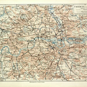
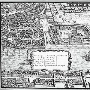
London Map 1756

![]()
Wall Art and Photo Gifts from Mary Evans Picture Library
London Map 1756
London still surrounded by fields, with Tyburn (note the gallows) and Buckingham House on the outskirts. Trafalgar Square doesn t exist, and Mayfair is still undeveloped
Mary Evans Picture Library makes available wonderful images created for people to enjoy over the centuries
Media ID 587889
© Mary Evans Picture Library 2015 - https://copyrighthub.org/s0/hub1/creation/maryevans/MaryEvansPictureID/10187933
1756 Buckingham Exist Fields Gallows Maps Mayfair Note Outskirts Plans Surrounded Trafalgar Tyburn Undeveloped
FEATURES IN THESE COLLECTIONS
> Europe
> United Kingdom
> England
> London
> Sights
> Trafalgar Square
> Europe
> United Kingdom
> England
> Maps
> Maps and Charts
> Early Maps
EDITORS COMMENTS
This fascinating print of the "London Map 1756" takes us back in time to a London that is almost unrecognizable from the bustling metropolis we know today. In this map, London is still surrounded by vast fields, with only Tyburn (note the gallows) and Buckingham House on the outskirts of the city. Trafalgar Square has yet to be built, and Mayfair remains undeveloped.
The intricate details of this historical map provide a glimpse into what life was like in 18th century England. The plans and layouts depicted here offer a unique perspective on how urban development has transformed over the centuries.
As you study this map closely, you can't help but marvel at how much London has evolved since 1756. The contrast between then and now is striking, highlighting just how much history is woven into every corner of this vibrant city.
Whether you're a history buff or simply appreciate fine art, this print from Mary Evans Picture Library is sure to captivate your imagination and spark curiosity about London's rich past. It serves as a reminder that even in an ever-changing world, traces of our heritage are always waiting to be discovered.
MADE IN THE UK
Safe Shipping with 30 Day Money Back Guarantee
FREE PERSONALISATION*
We are proud to offer a range of customisation features including Personalised Captions, Color Filters and Picture Zoom Tools
SECURE PAYMENTS
We happily accept a wide range of payment options so you can pay for the things you need in the way that is most convenient for you
* Options may vary by product and licensing agreement. Zoomed Pictures can be adjusted in the Basket.