Canvas Print > Europe > France > Canton > Landes
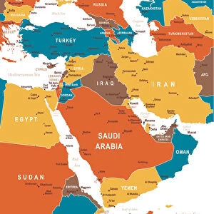
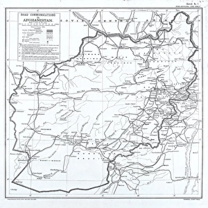
Canvas Print : 1855, Colton Map of Persia, Afghanistan, and Arabia, topography, cartography, geography


![]()
Canvas Prints from Liszt Collection
1855, Colton Map of Persia, Afghanistan, and Arabia, topography, cartography, geography
1855, Colton Map of Persia, Afghanistan, and Arabia
Liszt Collection of nineteenth-century engravings and images to browse and enjoy
Media ID 14005483
© Artokoloro Quint Lox Limited
1855 Afghanistan Antique Map Atlas Chart Geographic Latitude Longitude Mappa Mundi Old Antique Plan Old Antique View Old Map Ols Antique Map Rare Old Maps Topo
20"x16" (50x40cm) Canvas Print
"Discover the rich history and geography of Persia, Afghanistan, and Arabia with our stunning Canvas Prints from Media Storehouse. Featuring the intricately detailed 1855 Colton Map from the renowned Liszt Collection, these prints bring the cartographic masterpiece to life in your home or office. Each print is meticulously reproduced on high-quality canvas, ensuring vibrant colors and sharp details that capture the essence of this historical map. Transport yourself back in time and add a touch of world history to your decor with Media Storehouse Canvas Prints."
Ready to hang Premium Gloss Canvas Print. Our archival quality canvas prints are made from Polyester and Cotton mix and stretched over a 1.25" (32mm) kiln dried knot free wood stretcher bar. Packaged in a plastic bag and secured to a cardboard insert for transit.
Canvas Prints add colour, depth and texture to any space. Professionally Stretched Canvas over a hidden Wooden Box Frame and Ready to Hang
Estimated Product Size is 50.8cm x 40.6cm (20" x 16")
These are individually made so all sizes are approximate
Artwork printed orientated as per the preview above, with landscape (horizontal) orientation to match the source image.
FEATURES IN THESE COLLECTIONS
> Asia
> Afghanistan
> Maps
> Asia
> Afghanistan
> Related Images
> Europe
> France
> Canton
> Landes
> Historic
> Space exploration
> Maps and Charts
> Early Maps
> Maps and Charts
> Related Images
> Maps and Charts
> World
EDITORS COMMENTS
This print showcases the exquisite 1855 Colton Map of Persia, Afghanistan, and Arabia. A true masterpiece in topography, cartography, and geography, this vintage map takes us on a journey through time to explore the ancient lands of the Middle East. The intricate details depicted on this historic piece of art transport us back to an era when exploration and discovery were at their peak. The carefully drawn lines represent latitude and longitude, creating a geometric grid that guides our imagination across vast regions. As we gaze upon this aged treasure, we are reminded of the importance of maps in navigation and understanding our world. Its decorative elements add a touch of elegance to its historical significance. With every contour meticulously illustrated, we can almost feel the texture of the land beneath our fingertips. This rare old map provides us with a glimpse into how these regions were perceived centuries ago. Transport yourself back in time as you admire this antique plan that once guided travelers through uncharted territories. Let your mind wander through space as you immerse yourself in this mappa mundi filled with tales from distant lands. Whether you are an avid history enthusiast or simply appreciate fine artistry, this Colton Map print is sure to captivate your senses and ignite your curiosity about these fascinating regions that have shaped our world's history for centuries.
MADE IN THE UK
Safe Shipping with 30 Day Money Back Guarantee
FREE PERSONALISATION*
We are proud to offer a range of customisation features including Personalised Captions, Color Filters and Picture Zoom Tools
SECURE PAYMENTS
We happily accept a wide range of payment options so you can pay for the things you need in the way that is most convenient for you
* Options may vary by product and licensing agreement. Zoomed Pictures can be adjusted in the Basket.