Canvas Print > Granger Art on Demand > Maps
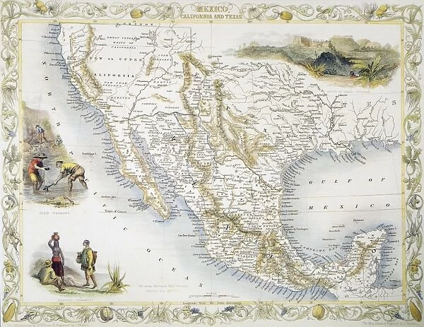
Canvas Print : MEXICO: MAP, 1851. Map of Mexico, California, and Texas by John Tallis, 1851
![]()

Canvas Prints from Granger
MEXICO: MAP, 1851. Map of Mexico, California, and Texas by John Tallis, 1851
Granger holds millions of images spanning more than 25,000 years of world history, from before the Stone Age to the dawn of the Space Age
Media ID 6617685
1851 California Latin America Latin American Manifest Destiny Mesoamerica Mesoamerican Mexican Mexico South West Texas Tallis
20"x16" (50x40cm) Canvas Print
Discover the rich history of North America with our stunning Canvas Print of "MEXICO: MAP, 1851. Map of Mexico, California, and Texas by John Tallis, 1851" from Media Storehouse and The Granger Collection. This captivating vintage map, dated 1851, showcases the territories of Mexico, California, and Texas during a pivotal time in North American history. Each detail is beautifully rendered in crisp, high-resolution, allowing the intricate lines and borders to stand out. Bring a piece of historical cartography into your home or office with this unique and intriguing Canvas Print. Order now from Media Storehouse and add a touch of history to your space.
Ready to hang Premium Gloss Canvas Print. Our archival quality canvas prints are made from Polyester and Cotton mix and stretched over a 1.25" (32mm) kiln dried knot free wood stretcher bar. Packaged in a plastic bag and secured to a cardboard insert for transit.
Canvas Prints add colour, depth and texture to any space. Professionally Stretched Canvas over a hidden Wooden Box Frame and Ready to Hang
Estimated Product Size is 50.8cm x 40.6cm (20" x 16")
These are individually made so all sizes are approximate
Artwork printed orientated as per the preview above, with landscape (horizontal) orientation to match the source image.
Discovering the Rich Tapestry of Mexico - A Glimpse into History
EDITORS COMMENTS
. This print showcases a remarkable piece of cartographic art, "MEXICO: MAP, 1851" created by the renowned John Tallis in the year 1851. The map itself offers an intricate depiction of Mexico, California, and Texas during a time when these regions were undergoing significant transformations. With its detailed illustrations and precise geographical accuracy, this vintage map transports us back to an era where exploration and expansion shaped the destiny of nations. It serves as a visual testament to the historical significance of Mexico's role in shaping Latin America. The inclusion of California and Texas highlights their pivotal position within North America's westward expansion. As we gaze upon this masterpiece, it becomes evident that this region was not only influenced by indigenous cultures but also impacted by American settlers seeking new opportunities during Manifest Destiny. Moreover, this artwork provides a glimpse into Mesoamerica's rich heritage with its depiction of rivers flowing through vast landscapes. These waterways symbolize both connectivity and sustenance for ancient civilizations that once thrived in these lands. As we admire this print from Granger Art on Demand, let us appreciate how it encapsulates centuries worth of history within its borders. It invites us to delve deeper into our understanding of Mexican culture while reminding us that maps are not merely tools for navigation but gateways to uncovering stories waiting to be told.
MADE IN THE UK
Safe Shipping with 30 Day Money Back Guarantee
FREE PERSONALISATION*
We are proud to offer a range of customisation features including Personalised Captions, Color Filters and Picture Zoom Tools
SECURE PAYMENTS
We happily accept a wide range of payment options so you can pay for the things you need in the way that is most convenient for you
* Options may vary by product and licensing agreement. Zoomed Pictures can be adjusted in the Basket.


