Home > Animals > Insects > Butterflies > Viceroy
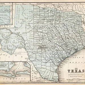
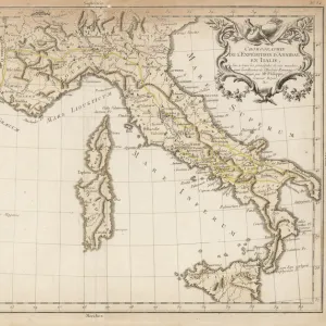
MAP: GULF COAST, 1757. Map of the Gulf Coast of the then Province of Texas, made

![]()
Wall Art and Photo Gifts from Granger
MAP: GULF COAST, 1757. Map of the Gulf Coast of the then Province of Texas, made
MAP: GULF COAST, 1757.
Map of the Gulf Coast of the then Province of Texas, made and sent to Spain by the Viceroy of New Spain, 18 April 1757
Granger holds millions of images spanning more than 25,000 years of world history, from before the Stone Age to the dawn of the Space Age
Media ID 12568215
1757 April Coast Colony Gulf Latin America Mesoamerica New Spain Province Southwest Spanish Texas United States
FEATURES IN THESE COLLECTIONS
> Animals
> Insects
> Butterflies
> Viceroy
> Arts
> Landscape paintings
> Waterfall and river artworks
> River artworks
> Granger Art on Demand
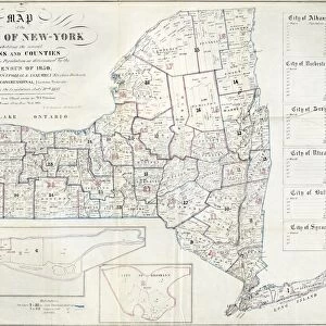
> U.S. States
> Maps and Charts
> Spain
EDITORS COMMENTS
MAP: GULF COAST, 1757. A fascinating glimpse into the historical landscape of the Gulf Coast, this meticulously detailed map offers a window into the then Province of Texas in 1757. Created and sent to Spain by the Viceroy of New Spain on April 18th, this remarkable piece showcases the intricate knowledge and cartographic skills of its time. The map captures not only geographical features but also provides insight into the political dynamics that shaped colonial America. It highlights Spanish influence in Latin America and Mesoamerica during this period, shedding light on their exploration and colonization efforts. As we examine this print, we can trace rivers meandering through vast stretches of land while coastal lines define borders between nations. The southwest region comes alive with rich details depicting settlements and colonies that were instrumental in shaping early American history. This artifact serves as a reminder of how maps have been crucial tools for understanding our world throughout centuries. It invites us to reflect upon the journeys undertaken by explorers who ventured into uncharted territories, paving the way for future generations. Whether you are an avid historian or simply captivated by artistry from times past, this print transports you back to a pivotal moment when boundaries were being drawn and new frontiers beckoned adventurers.
MADE IN THE UK
Safe Shipping with 30 Day Money Back Guarantee
FREE PERSONALISATION*
We are proud to offer a range of customisation features including Personalised Captions, Color Filters and Picture Zoom Tools
SECURE PAYMENTS
We happily accept a wide range of payment options so you can pay for the things you need in the way that is most convenient for you
* Options may vary by product and licensing agreement. Zoomed Pictures can be adjusted in the Basket.