Antique Framed Print > Europe > United Kingdom > England > Maps
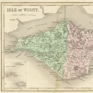
Antique Framed Print : 1879, Stanford Pocket Map of the Isle of Wight, England, topography, cartography


![]()
Framed Photos from Liszt Collection
1879, Stanford Pocket Map of the Isle of Wight, England, topography, cartography
1879, Stanford Pocket Map of the Isle of Wight, England
Liszt Collection of nineteenth-century engravings and images to browse and enjoy
Media ID 14006403
© Artokoloro Quint Lox Limited
1879 Antique Map Atlas Chart Geographic Latitude Longitude Mappa Mundi Old Antique Plan Old Antique View Old Map Ols Antique Map Rare Old Maps Topo
14"x12" (36x31cm) Antique Frame
Bevelled wood effect frame, card mounted, 10x8 archival quality photo print. Overall outside dimensions 14x12 inches (36x31cm). Environmentally and ozone friendly, the Polycore® moulding has the look of real wood, is durable and light and easy to hang. Biodegradable and made with non-chlorinated gases (no toxic fumes) it is efficient; producing 100 tons of polystyrene can save 300 tons of trees! Prints are glazed with lightweight, shatterproof, optical clarity acrylic (providing the same general protection from the environment as glass). The back is stapled hardboard with a sawtooth hanger attached. Note: To minimise original artwork cropping, for optimum layout, and to ensure print is secure, the visible print may be marginally smaller
Bevelled Wood Effect Framed and Mounted Prints - Professionally Made and Ready to Hang
Estimated Image Size (if not cropped) is 24.4cm x 18.1cm (9.6" x 7.1")
Estimated Product Size is 36.3cm x 31.2cm (14.3" x 12.3")
These are individually made so all sizes are approximate
Artwork printed orientated as per the preview above, with landscape (horizontal) orientation to match the source image.
EDITORS COMMENTS
This print showcases the exquisite 1879 Stanford Pocket Map of the Isle of Wight, England. A true masterpiece in topography and cartography, this map offers a glimpse into the island's rich geographic features and historical significance. With its intricate details and precise measurements, it serves as both a navigational tool and an artistic representation of the region. The vintage charm exuded by this ancient map takes us back to a time when paper was meticulously crafted to document our world. Its retro aesthetics evoke a sense of nostalgia for those who appreciate historical artifacts. This decorative piece not only adds character to any space but also sparks curiosity about past journeys and discoveries made on this enchanting island. As we explore every corner of this old antique view, we are reminded of the importance placed on geographical knowledge throughout history. The grid lines, latitude, longitude markings, and geometric precision remind us that maps have always been essential tools for navigation and exploration. Whether you are an avid collector or simply fascinated by geography and history, this rare gem is sure to captivate your imagination. It serves as a testament to mankind's enduring quest for understanding our planet's diverse landscapes while offering a glimpse into the Isle of Wight's unique beauty through artful illustration.
MADE IN THE UK
Safe Shipping with 30 Day Money Back Guarantee
FREE PERSONALISATION*
We are proud to offer a range of customisation features including Personalised Captions, Color Filters and Picture Zoom Tools
SECURE PAYMENTS
We happily accept a wide range of payment options so you can pay for the things you need in the way that is most convenient for you
* Options may vary by product and licensing agreement. Zoomed Pictures can be adjusted in the Basket.