Tote Bag > Asia > Turkey > Related Images
Tote Bag : old map of europe


![]()
Home Decor from Fine Art Storehouse
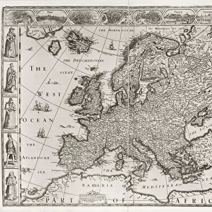
old map of europe
an old map form 1883, showing european countries
Unleash your creativity and transform your space into a visual masterpiece!
THEPALMER
Media ID 15134767
© Roberto A Sanchez
Austria Backgrounds Direction European Community Grunge Map02 Mediterranean Countries Mediterranean Sea National Border Paper Patina Retro Revival Rust Rusty Sepia Toned Textured Effect Torn Turkey Obsolete
Canvas Tote Bag
Our tote bags are made from soft, durable, poly-poplin fabric and include a one inch (2.5cm) black strap for easy carrying on your shoulder. All seams are double-stitched for added durability. Each tote bag is machine-washable in cold water and is printed on both sides using the same image. Approximate size of bag is 50x33cm (20"x13")
Our tote bags are made from soft durable fabric and include a strap for easy carrying
Estimated Product Size is 50cm x 32.7cm (19.7" x 12.9")
These are individually made so all sizes are approximate
FEATURES IN THESE COLLECTIONS
> Fine Art Storehouse
> Map
> Historical Maps
> Fine Art Storehouse
> Map
> Italian Maps
> Asia
> Turkey
> Related Images
> Europe
> Austria
> Related Images
> Europe
> Italy
> Related Images
> Europe
> Related Images
EDITORS COMMENTS
This print titled "Old Map of Europe" takes us on a journey back in time to the year 1883. The image showcases a beautifully preserved map, revealing the European countries as they were over a century ago. With its intricate cartography and faded sepia tones, this piece exudes an air of retro revival and nostalgia. The map highlights the Mediterranean countries prominently, reminding us of their historical significance and cultural richness. Each national border is delicately drawn, reflecting the meticulous attention to detail that was characteristic of old-world cartographers. The physical geography is also depicted with textured effects, giving it an authentic feel. As we explore this vintage treasure further, we notice signs of age - rusty edges and torn corners - adding to its charm and authenticity. The paper itself bears witness to history's passage; it carries a patina that tells stories untold. From Turkey to Spain, Italy to Austria, France to England – all these nations are intricately woven together on this old map representing Europe's diverse tapestry. The Mediterranean Sea acts as both a unifying force and a gateway for trade and exploration throughout history. With its grunge aesthetic combined with elements of antiquity, this artwork by THEPALMER transports us into another era altogether. It serves as a reminder of how borders have shifted over time while celebrating our shared heritage rooted in European community.
MADE IN THE UK
Safe Shipping with 30 Day Money Back Guarantee
FREE PERSONALISATION*
We are proud to offer a range of customisation features including Personalised Captions, Color Filters and Picture Zoom Tools
SECURE PAYMENTS
We happily accept a wide range of payment options so you can pay for the things you need in the way that is most convenient for you
* Options may vary by product and licensing agreement. Zoomed Pictures can be adjusted in the Basket.