Premium Framed Print > Animals > Mammals > Cricetidae > Meridionalis
Premium Framed Print : 17th century map of South America


![]()
Framed Photos from Science Photo Library
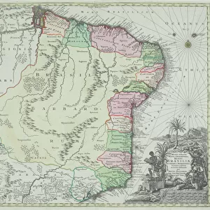
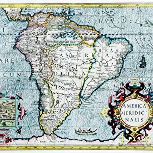
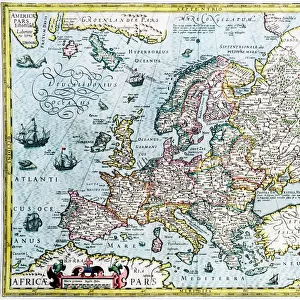
17th century map of South America
South America, 17th century Dutch map. This shows the new continent that was being discovered by European explorers. The shape is distorted because it had not yet been accurately mapped. Two large rivers in Brazil are shown flowing from a large lake in eastern Brazil. The western coastline is by now fairly accurately mapped, but it was still not realised that Tierra del Fuego (bottom centre) in the Straits of Magellan, was a group of islands and not part of a large southern continent. The inset at lower left shows the Incan city of Cuzco in Peru. This map, published around 1630 by Jodocus Hondius, continued the earlier work of Gerard Mercator
Science Photo Library features Science and Medical images including photos and illustrations
Media ID 6350551
© GEORGETTE DOUWMA/SCIENCE PHOTO LIBRARY
17th Century Aboriginal Age Of Discovery Ancient Cartography City Civilization Distorted Distortion Dutch Earth Science Exploration Exploring Illustrated Inaccurate Inca Incan Incomplete Latin Mapping Maps Mercator New World Sciences Seventeenth South America Tierra Del Fuego 1630 Cuzco Gerard Gerardus Hondius Jodocus Native Americans
17"x15" (43x38cm) Premium Frame
FSC real wood frame with double mounted 10x8 print. Double mounted with white conservation mountboard. Frame moulding comprises stained composite natural wood veneers (Finger Jointed Pine) 39mm wide by 21mm thick. Archival quality Fujifilm CA photo paper mounted onto 1mm card. Overall outside dimensions are 17x15 inches (431x381mm). Rear features Framing tape to cover staples, 50mm Hanger plate, cork bumpers. Glazed with durable thick 2mm Acrylic to provide a virtually unbreakable glass-like finish. Acrylic Glass is far safer, more flexible and much lighter than typical mineral glass. Moreover, its higher translucency makes it a perfect carrier for photo prints. Acrylic allows a little more light to penetrate the surface than conventional glass and absorbs UV rays so that the image and the picture quality doesn't suffer under direct sunlight even after many years. Easily cleaned with a damp cloth. Please note that, to prevent the paper falling through the mount window and to prevent cropping of the original artwork, the visible print may be slightly smaller to allow the paper to be securely attached to the mount without any white edging showing and to match the aspect ratio of the original artwork.
FSC Real Wood Frame and Double Mounted with White Conservation Mountboard - Professionally Made and Ready to Hang
Estimated Image Size (if not cropped) is 24.4cm x 17.7cm (9.6" x 7")
Estimated Product Size is 43.1cm x 38.1cm (17" x 15")
These are individually made so all sizes are approximate
Artwork printed orientated as per the preview above, with landscape (horizontal) orientation to match the source image.
FEATURES IN THESE COLLECTIONS
> Animals
> Fishes
> G
> Grouper
> Animals
> Mammals
> Cricetidae
> Meridionalis
> Animals
> Mammals
> Muridae
> Western Mouse
> Animals
> Mammals
> Sciuridae
> Meridionalis
> Arts
> Artists
> H
> Jodocus Hondius
> Arts
> Artists
> M
> Gerardus Mercator
> Arts
> Landscape paintings
> Waterfall and river artworks
> River artworks
> Historic
> Ancient civilizations
> Inca Civilization
> Ancient civilizations
> Historic
> Ancient civilizations
> Inca Civilization
> Historic
> Ancient civilizations
> Maps and Charts
> Gerardus Mercator's Cartographic
EDITORS COMMENTS
This print showcases a 17th-century Dutch map of South America, shedding light on the era of European exploration and discovery. The distorted shape of the continent reflects the limited accuracy in mapping during that time. Notably, two prominent rivers in Brazil are depicted as flowing from a large lake in eastern Brazil, while the western coastline is relatively well-mapped. However, it was not yet realized that Tierra del Fuego, situated at the bottom center within the Straits of Magellan, actually comprised a group of islands rather than part of a larger southern continent. The inset at lower left offers an intriguing glimpse into Incan civilization with an illustration depicting Cuzco, an ancient city located in Peru. Published around 1630 by Jodocus Hondius and building upon earlier work by Gerard Mercator, this map represents an important milestone in cartography during the Age of Discovery. While incomplete and inaccurate by modern standards due to limited knowledge about native peoples and geography at that time, this historic artwork serves as a testament to humanity's relentless pursuit of knowledge and understanding. It invites us to appreciate how far we have come since then in unraveling Earth's mysteries through advancements in earth science and mapping techniques.
MADE IN THE UK
Safe Shipping with 30 Day Money Back Guarantee
FREE PERSONALISATION*
We are proud to offer a range of customisation features including Personalised Captions, Color Filters and Picture Zoom Tools
SECURE PAYMENTS
We happily accept a wide range of payment options so you can pay for the things you need in the way that is most convenient for you
* Options may vary by product and licensing agreement. Zoomed Pictures can be adjusted in the Basket.