Premium Framed Print > Historic > Ancient civilizations > Roman Empire > Roman art
Premium Framed Print : Roman Empire, circa 200 AD


![]()
Framed Photos from North Wind
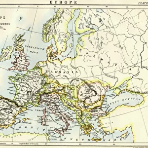
Roman Empire, circa 200 AD
Map of the Roman Empire in the third century.
Printed color lithograph of a 19th-century illustration
North Wind Picture Archives brings history to life with stock images and hand-colored illustrations
Media ID 5877963
© North Wind Picture Archives
Africa Ancient Ancient Civilization Ancient History Ancient Roman Antiquity Asia Minor Britain British Isles Civilization Classical Classical Civilization England Europe European Gaul Mediterranean Sea Mid East Middle East North Africa Roman Roman Empire Territory 200s 3rd Century Gallia Germania Iberia Sarmatia
17"x15" (43x38cm) Premium Frame
FSC real wood frame with double mounted 10x8 print. Double mounted with white conservation mountboard. Frame moulding comprises stained composite natural wood veneers (Finger Jointed Pine) 39mm wide by 21mm thick. Archival quality Fujifilm CA photo paper mounted onto 1mm card. Overall outside dimensions are 17x15 inches (431x381mm). Rear features Framing tape to cover staples, 50mm Hanger plate, cork bumpers. Glazed with durable thick 2mm Acrylic to provide a virtually unbreakable glass-like finish. Acrylic Glass is far safer, more flexible and much lighter than typical mineral glass. Moreover, its higher translucency makes it a perfect carrier for photo prints. Acrylic allows a little more light to penetrate the surface than conventional glass and absorbs UV rays so that the image and the picture quality doesn't suffer under direct sunlight even after many years. Easily cleaned with a damp cloth. Please note that, to prevent the paper falling through the mount window and to prevent cropping of the original artwork, the visible print may be slightly smaller to allow the paper to be securely attached to the mount without any white edging showing and to match the aspect ratio of the original artwork.
FSC Real Wood Frame and Double Mounted with White Conservation Mountboard - Professionally Made and Ready to Hang
Estimated Image Size (if not cropped) is 24.4cm x 16.9cm (9.6" x 6.7")
Estimated Product Size is 43.1cm x 38.1cm (17" x 15")
These are individually made so all sizes are approximate
Artwork printed orientated as per the preview above, with landscape (horizontal) orientation to match the source image.
FEATURES IN THESE COLLECTIONS
> North Wind Picture Archives
> Ancient history
> North Wind Picture Archives
> Maps
> Africa
> Related Images
> Arts
> Artists
> R
> Roman Roman
> Asia
> Related Images
> Europe
> United Kingdom
> England
> Maps
> Historic
> Ancient civilizations
> Roman Empire
> Roman art
> Historic
> Ancient civilizations
> Roman Empire
> Historic
> Ancient civilizations
> Maps and Charts
> British Empire Maps
> Maps and Charts
> Early Maps
EDITORS COMMENTS
This vibrant and detailed print showcases the vast expanse of the Roman Empire during its height in the third century. Created from a 19th-century illustration, this color lithograph brings to life the ancient world of Europe, Britain, and beyond. The map reveals the extensive territory controlled by Rome, stretching from Gaul (modern-day France) to Germania (Germany), Iberia (Spain), and even parts of Sarmatia (Eastern Europe). The British Isles are also prominently featured as an integral part of the empire. As we explore further south, we encounter North Africa and the Middle East, including Asia Minor. The Mediterranean Sea acts as a central hub connecting these diverse regions that were united under Roman rule. This visual representation offers a glimpse into classical civilization at its peak - a time when art, culture, and architecture flourished throughout these lands. Through this historic illustration, we can appreciate both the grandeur and complexity of one of history's most influential empires. It serves as a reminder of how far-reaching Roman influence was during this era – shaping not only European history but also leaving an indelible mark on Africa and Asia Minor. Whether you're fascinated by ancient civilizations or simply admire vintage artwork with historical significance, this print is sure to transport you back in time to experience firsthand the power and majesty of the Roman Empire circa 200 AD.
MADE IN THE UK
Safe Shipping with 30 Day Money Back Guarantee
FREE PERSONALISATION*
We are proud to offer a range of customisation features including Personalised Captions, Color Filters and Picture Zoom Tools
SECURE PAYMENTS
We happily accept a wide range of payment options so you can pay for the things you need in the way that is most convenient for you
* Options may vary by product and licensing agreement. Zoomed Pictures can be adjusted in the Basket.