Glass Frame > Historic > Ancient civilizations > Roman Empire > Roman art
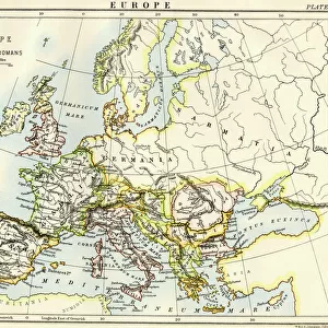
Glass Frame : Roman Empire, circa 200 AD


![]()
Mounted Prints from North Wind
Roman Empire, circa 200 AD
Map of the Roman Empire in the third century.
Printed color lithograph of a 19th-century illustration
North Wind Picture Archives brings history to life with stock images and hand-colored illustrations
Media ID 5877963
© North Wind Picture Archives
Africa Ancient Ancient Civilization Ancient History Ancient Roman Antiquity Asia Minor Britain British Isles Civilization Classical Classical Civilization England Europe European Gaul Mediterranean Sea Mid East Middle East North Africa Roman Roman Empire Territory 200s 3rd Century Gallia Germania Iberia Sarmatia
7"x5" Glass Mount
Wall mounted or free-standing, these black edged glass frames feature a smooth chamfered edge and a stylish black border (on back face of the glass). Manufactured from 4mm thick glass, Glass Mounts are a durable, professional way of displaying and protecting your prints. Your 7x5 print is slotted into the back of the frame so can easily be changed if needed.
Tempered Glass Mounts are ideal for wall display, plus the smaller sizes can also be used free-standing via an integral stand
Estimated Image Size (if not cropped) is 17.7cm x 12.7cm (7" x 5")
Estimated Product Size is 20.3cm x 16.2cm (8" x 6.4")
These are individually made so all sizes are approximate
Artwork printed orientated as per the preview above, with landscape (horizontal) orientation to match the source image.
FEATURES IN THESE COLLECTIONS
> Africa
> Related Images
> Arts
> Artists
> R
> Roman Roman
> Asia
> Related Images
> Europe
> United Kingdom
> England
> Maps
> Historic
> Ancient civilizations
> Roman Empire
> Roman art
> Historic
> Ancient civilizations
> Roman Empire
> Historic
> Ancient civilizations
> Maps and Charts
> British Empire Maps
> Maps and Charts
> Early Maps
> North Wind Picture Archives
> Ancient history
> North Wind Picture Archives
> Maps
EDITORS COMMENTS
This vibrant and detailed print showcases the vast expanse of the Roman Empire during its height in the third century. Created from a 19th-century illustration, this color lithograph brings to life the ancient world of Europe, Britain, and beyond. The map reveals the extensive territory controlled by Rome, stretching from Gaul (modern-day France) to Germania (Germany), Iberia (Spain), and even parts of Sarmatia (Eastern Europe). The British Isles are also prominently featured as an integral part of the empire. As we explore further south, we encounter North Africa and the Middle East, including Asia Minor. The Mediterranean Sea acts as a central hub connecting these diverse regions that were united under Roman rule. This visual representation offers a glimpse into classical civilization at its peak - a time when art, culture, and architecture flourished throughout these lands. Through this historic illustration, we can appreciate both the grandeur and complexity of one of history's most influential empires. It serves as a reminder of how far-reaching Roman influence was during this era – shaping not only European history but also leaving an indelible mark on Africa and Asia Minor. Whether you're fascinated by ancient civilizations or simply admire vintage artwork with historical significance, this print is sure to transport you back in time to experience firsthand the power and majesty of the Roman Empire circa 200 AD.
MADE IN THE UK
Safe Shipping with 30 Day Money Back Guarantee
FREE PERSONALISATION*
We are proud to offer a range of customisation features including Personalised Captions, Color Filters and Picture Zoom Tools
SECURE PAYMENTS
We happily accept a wide range of payment options so you can pay for the things you need in the way that is most convenient for you
* Options may vary by product and licensing agreement. Zoomed Pictures can be adjusted in the Basket.