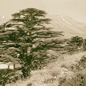
Premium Framed Print > Asia > Lebanon > Maps
Premium Framed Print : WW2 - Map of Beirut, Lebanon - with Military locations


![]()
Framed Photos From Mary Evans Picture Library
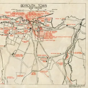
WW2 - Map of Beirut, Lebanon - with Military locations
End of WW2 - Map of Beirut, Lebanon showing Military locations important for a British serviceman stationed in the city at the end of the Second World War. The reverse of the map lists the Dos and Don ts whilst on leave in the city! Date: 1945
Mary Evans Picture Library makes available wonderful images created for people to enjoy over the centuries
Media ID 14391078
© Mary Evans / Pharcide
1945 Airport Beirut Beyrouth Chart Cinema Clubs Hostel Lebanese Lebanon Locations Plan
17"x15" (43x38cm) Premium Frame
FSC real wood frame with double mounted 10x8 print. Double mounted with white conservation mountboard. Frame moulding comprises stained composite natural wood veneers (Finger Jointed Pine) 39mm wide by 21mm thick. Archival quality Fujifilm CA photo paper mounted onto 1mm card. Overall outside dimensions are 17x15 inches (431x381mm). Rear features Framing tape to cover staples, 50mm Hanger plate, cork bumpers. Glazed with durable thick 2mm Acrylic to provide a virtually unbreakable glass-like finish. Acrylic Glass is far safer, more flexible and much lighter than typical mineral glass. Moreover, its higher translucency makes it a perfect carrier for photo prints. Acrylic allows a little more light to penetrate the surface than conventional glass and absorbs UV rays so that the image and the picture quality doesn't suffer under direct sunlight even after many years. Easily cleaned with a damp cloth. Please note that, to prevent the paper falling through the mount window and to prevent cropping of the original artwork, the visible print may be slightly smaller to allow the paper to be securely attached to the mount without any white edging showing and to match the aspect ratio of the original artwork.
FSC Real Wood Frame and Double Mounted with White Conservation Mountboard - Professionally Made and Ready to Hang
Estimated Image Size (if not cropped) is 24.4cm x 19.7cm (9.6" x 7.8")
Estimated Product Size is 43.1cm x 38.1cm (17" x 15")
These are individually made so all sizes are approximate
Artwork printed orientated as per the preview above, with landscape (horizontal) orientation to match the source image.
FEATURES IN THESE COLLECTIONS
> Asia
> Lebanon
> Related Images
> Historic
> World War I and II
> World War II
> Maps and Charts
> Related Images
> Maps and Charts
> World
EDITORS COMMENTS
This vintage map of Beirut, Lebanon, dates back to the end of World War II in 1945. The map provides an intriguing glimpse into the city as it appeared during that historical period, with a specific focus on military locations that would have been of particular importance to a British serviceman stationed in the area. The map is rich in detail, highlighting various military installations, barracks, and camps scattered throughout the city. These included the British Military Headquarters located near the Martyrs' Square, the Royal Army Ordnance Corps Depot in Ras Beirut, and the Royal Navy Base at the Beirut Waterfront. On the reverse side of the map, a list of "Dos and Don'ts" is provided for the serviceman on his leave in the city. The "Dos" include recommendations to visit popular clubs and cinemas such as the American Club, the British Club, and the Riviera Cinema. The "Don'ts," on the other hand, caution against visiting certain areas of the city, particularly those with a high crime rate or known to be off-limits to Allied personnel. The map also includes various other points of interest, such as hotels, hostels, and the Beirut International Airport. The Lebanese capital was a bustling hub of activity during the post-war period, and this map offers a fascinating insight into the city's military and social landscape at that time. This map is a valuable historical document, providing a unique perspective on Beirut during the waning days of World War II and the early days of the peace that followed. It is a reminder of the rich history and cultural diversity of this fascinating city and the role it played in world events during that era.
MADE IN THE UK
Safe Shipping with 30 Day Money Back Guarantee
FREE PERSONALISATION*
We are proud to offer a range of customisation features including Personalised Captions, Color Filters and Picture Zoom Tools
SECURE PAYMENTS
We happily accept a wide range of payment options so you can pay for the things you need in the way that is most convenient for you
* Options may vary by product and licensing agreement. Zoomed Pictures can be adjusted in the Basket.